Hamilton in Steuben County, Indiana — The American Midwest (Great Lakes)
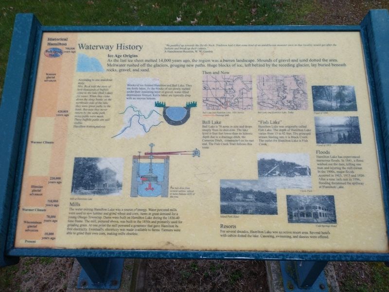
Waterway History
"We paddled up towards the Dells Neck. Tradition had it that some kind of an antediluvian monster once in that locality would get after the Indians and break up their canoes."
A Hamiltonian Reunion, W.W. Gambia
Ice Age Origins
As the last ice sheet melted 14,000 years ago, the region was a barren landscape. Mounds of gravel and sand dotted the area. Meltwater rushed off the glaciers, gouging new paths. Huge blocks of ice, left behind by the receding glacier, lay buried beneath rocks, gravel, and sand.
According to one anecdotal story: Mrs. Buck told the story of how thousands of buffalo came yo the lake (Ball Lake) for water. When they came down the seep banks on the northwest side of the lake there were great paths in the bank. Because they never returned by the same path, many paths were made. These buffalo paths are still visible.
Hamilton Retrospectives
Blocks of ice formed Hamilton and Ball Lake. They are kettle lakes. As the blocks of ice slowly melted under their insulating layer of gravel, water-filled depressions formed. Kettle lakes are typically deep with an uneven bottom.
Mill at Hamilton Lake
Mills
The water exiting Hamilton Lake was a source of energy. Water powered mills were used to saw lumber and grind wheat and corn, items in great demand for a young Otsego Township. Dams were built on Hamilton Lake during the 1836-40 time frame. The mill, pictured above, was built in the 1850s and primarily used for grinding grain At one point the mill powered a generator that gave Hamilton its first electricity. Eventually, electricity was made available to farms. Farmers were able to grind their own com, making mills obsolete.
Ball Lake
Ball Lake is 78 acres in size and drops steeply from its shoreline. The lake level is four feet lower than its historic depth due to a drainage ditch, the Cameron Ditch, constructed on its east end. The Fish Creek Trail follows this route.
"Fish Lake"
Hamilton Lake was originally called Fish Lake. The depth of Hamilton Lake varies from 15 to 62 feet. The principal stream feeding into it is Black Creek. The outlet for Hamilton Lake is Fish Creek.
Floods
Hamilton Lake has experienced numerous floods. In 1841, a flood washed out the dam, killing one man and injuring the mill owner. In the 1900s, major floods secured in 19G3, 1913 and 1920. After a nine inch rain in 1996, flooding threatened the spillway at Hamilton Lake
Resorts
For several decades, Hamilton Lake was an active resort area. Several hotels with cabins dotted the lake. Canoeing, swimming, and dances were offered.
Historical Hamilton
700,020 years ago
Kansan glacial advances
420.009 years ago
Warmer Climate
220.000 years ago
Illusion glacial advances
110,060 years ago
Warmer Climate
70,000 years age
Wisconsin glacial advances
10,000 years age
Present
Topics. This historical marker is listed in this topic list: Waterways & Vessels. A significant historical year for this entry is 1841.
Location. 41° 31.996′ N, 84° 55.207′ W. Marker is in Hamilton, Indiana, in Steuben County. Marker can be reached from East Bellefountaine Road west of Peninsula Street, on the right when traveling east. Touch for map. Marker is at or near this postal address: 3779 E Church St, Hamilton IN 46742, United States of America. Touch for directions.
Other nearby markers. At least 8 other markers are within 3 miles of this marker, measured as the crow flies. Early Hamilton (here, next to this marker); Fish Creek Restoration (here, next to this marker); a different marker also named Fish Creek Restoration (a few steps from this marker); Native Americans (a few steps from this marker); Early Settlers (a few steps from this marker); Arthur Russell Perry (within shouting distance of this marker); Welcome to the Fish Creek Trail (within shouting distance of this marker); Site Of First Settler In DeKalb County (approx. 2.7 miles away). Touch for a list and map of all markers in Hamilton.
Credits. This page was last revised on May 5, 2022. It was originally submitted on April 26, 2022, by Craig Doda of Napoleon, Ohio. This page has been viewed 225 times since then and 40 times this year. Photos: 1, 2, 3. submitted on April 26, 2022, by Craig Doda of Napoleon, Ohio. • Devry Becker Jones was the editor who published this page.


