
Sandston in Henrico County, Virginia — The American South (Mid-Atlantic)
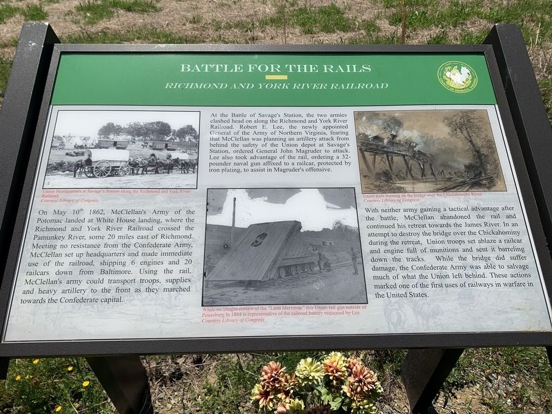
Battle For The Rails
Richmond and York River Railroad
Photographed by James Dean
1. Battle For The Rails Marker
At the Battle of Savage’s Station, the two armies clashed head on along the Richmond and York River Railroad. Robert E. Lee, the newly appointed General of the Army of Northern Virginia, fearing that McClellan was planning an artillery attack from behind the safety of the Union depot at Savage’s Station, ordered General John Magruder to attack. Lee also took advantage of the rail, ordering a 32-pounder naval gun affixed to a railcar, protected by iron plating, to assist in Magruder’s offensive.
With neither army gaining a tactical advantage after the battle, McClellan abandoned the rail and continued his retreat towards
this page online
(captions)
Union Headquarters at Savage’s Station along the Richmond and York River Railroad. Courtesy Library of Congress
While no images remain of the “Land Merrimac” this Union rail gun outside of Petersburg in 1864 is representative of the railroad battery requested by Lee. Courtesy Library of Congress
Union train burning on the bridge over the Chickahominy River. Courtesy Library of Congress
Erected by County of Henrico.
Topics. This historical marker is listed in these topic lists: Railroads & Streetcars • War, US Civil. A significant historical date for this entry is May 10, 1862.
Location. 37° 31.693′ N, 77° 16.135′ W. Marker is in Sandston, Virginia, in Henrico County. It is on Meadow Road (Virginia Route 156) 0.1 miles east

Photographed by Mike McKeown, April 6, 2024
2. Battle For The Rails Marker
Marker and CWT marker off of parking area.

Regionally, this marker is in Virginia’s Piedmont, in Central Virginia, and in the Richmond Metropolitan Area. It is also in the American South and specifically in the Upper South. Globally, it is in the North Atlantic Region, North America, the Western Hemisphere, the Western World, and the Anglosphere. Historically, it finds itself in what was once the territory of the Mississippian Culture, one of the original Thirteen Colonies, one of the Confederate States of America, and the Antebellum South.
Other nearby markers. At least 8 other markers are within 2 miles of this marker, measured as the crow flies: A different marker also named Battle of Savage's Station (here, next to this marker); Route to White Oak Swamp and Malvern Hill (a few steps from this marker); Savage Station (a few steps from this marker); a different marker also named The Trent House (approx. 1.2 miles away); a different marker also named Seven Days Battles (approx. 1.3 miles away); a different marker also named Battle of Savage's Station (approx. 1.4 miles away); a different marker also named The Trent House (approx. 1.4 miles away); a different marker also named Seven Days Battles (approx. 1.6 miles away). Touch for a list and map of all markers in Sandston.
Other markers no longer nearby. Seven Days Battles (was here, next to this marker but has been permanently removed); a different marker also named Seven Days Battles (was here, next to this marker but has been permanently removed); Battle of Savage’s Station (was here, next to this marker but has been confirmed missing); McClellan’s Withdrawal (was here, next to this marker but has been permanently removed); McClellan's Third Line (was approx. ¾ mile away but has been confirmed missing); The Trent House (was approx. 1.2 miles away but has been replaced with another marker now near it).
Credits. This page was last revised on April 26, 2025. It was originally submitted on April 27, 2022, by James Dean of Chesterfield, Virginia. This page has been viewed 690 times since then and 48 times this year. Photos: 1. submitted on April 27, 2022, by James Dean of Chesterfield, Virginia. 2. submitted on April 24, 2025, by Mike McKeown of Baltimore, Maryland. • Bernard Fisher was the editor who published this page.
