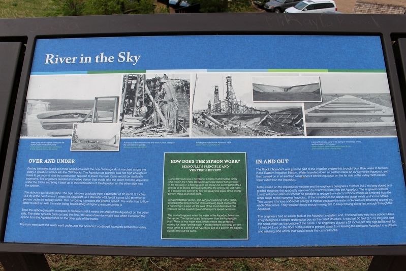
Near Brooks in Newell County, Alberta — Canada’s Prairie Region (North America)
River in the Sky
Over and under
The siphon is just a large pipe. The pipe narrows gradually from a diameter of 12 feet 8½ inches (3.8 m) at the point where it meets the Aqueduct, to a diameter of 9 feet 9 inches (2.9 m) when it passes under the railway tracks. This narrowing increases the water's speed. The water has to flow faster to keep up with the water being forced along at higher pressure behind it.
The the siphon gradually increases in diameter until it meets the shell of the Aqueduct on the other side. The water spreads back out and the flow rate slows down to what it was when it entered the siphon from the Aqueduct shell on the other side of the tracks.
The train went over, the water went under, and the Aqueduct continued its march across the valley.
In and out
The Brooks Aqueduct was just one part of the irrigation system that brought Bow River water to farmers in the Eastern Irrigation Section. Water travelled down an earthen canal on its way to the Aqueduct, and then carried on in an earthen canal when it left the Aqueduct on the far side of the valley. Both canals were wider than the Aqueduct.
At the intake at the Aqueduct's western end the engineers designed a 150 foot (45.7 m) long sloped and graded structure that gradually narrowed to direct the water into the Aqueduct. The engineers wanted to make the transition as smooth as possible to reduce the water's frictional losses as it moved from the wider canal to the narrower Aqueduct. If the transition is too abrupt the water swirls and forms eddies. This causes it to lose additional energy to friction because the water molecules are bouncing around into each other more. They wouldn't have enough energy left to keep moving along fast enough through the Aqueduct.
The engineers had an easier task at the Aqueduct's eastern end. Frictional loss was not a concern here. They designed a simple rectangular box as the outlet structure. It was just 30 feet (9.1 m) long and had the same width as the bottom of the canal. The engineer placed a 21 inch (53.3 cm) high baffle wall for 14 feet (4.2 m) on the floor of the outlet to prevent water from leaving the narrower Aqueduct in a stream and casuing side whirls that would erode the canal's banks.
How does the siphon work?
Bernoulli's Principle and Venturi's Effect
Daniel Bernoulli was a member of a Swiss mathematical family who lived in the 1700s. Bernoulli's principle states that a change in the pressure in a flowing liquid will always be accompanied by a change in its speed. Bernoulli noted that the energy per unit mass of a liquid at one point in its flow will always be equal to the energy per unit mass at another point.
Giovanni Bauttista Venturi, also living and working in the 1700s, described that phenomenon when a flowing liquid encounters a narrowing in a pipe. As the area of the liquid decreases, the pressure on the liquid drops and the liquid's speed increases.
This is what happens when the water in the Aqueduct flows into the siphon. The siphon's pipe is narrower than the Aqueduct's shell. There is less water area, which means less pressure, making for faster flowing water. A measurement of energy per unit mass taken at a point in the Aqueduct, and at a point in the siphon, would come out the same.
[Photo captions (left to right)]
• Waqter going into the siphon (main) and the siphon under construction (inset). Eastern Irrigation District Library and Archives, B-2028, Glenbow Archives NA-2622-69
• A close-up of the wooden forms and rebar in place, ready for the concrete to be poured. Glenbow Archives, NA-2622-63
• Building the intake to the Aqueduct, 1914. Glenbow Archives, NA-2622-68
• A shot of the intake canal in the spring of 1918 empty (inset), and the outlet in 1915 (main). Eastern Irrigation District Library and Archives, B-155, and Provincial Archives of Alberta, P821
Erected by Agriculture and Agri-Food Canada, Agri-Environment Services Branch.
Topics. This historical marker is listed in these topic lists: Bridges & Viaducts • Science & Medicine • Waterways & Vessels. A significant historical year for this entry is 1914.
Location. 50° 31.909′ N, 111° 50.251′ W. Marker is near Brooks, Alberta, in Newell County. Marker is on Range Road 142, 0.4 kilometers south of Township Road 183A Road, on the right when traveling south. Touch for map. Marker is in this post office area: Brooks AB T0J 3K0, Canada. Touch for directions.
Other nearby markers. At least 6 other markers are within walking distance of this marker. The River Runs Dry (here, next to this marker); a different marker also named River in the Sky (here, next to this marker); The Brooks Aqueduct/L’aqueduc de Brooks (within shouting distance of this marker); Welcome to the Brooks Aqueduct (within shouting distance of this marker); a different marker also named River in the Sky (approx. 1.4 kilometers away); a different marker also named River in the Sky (approx. 1.4 kilometers away).
Related markers. Click here for a list of markers that are related to this marker.
Credits. This page was last revised on May 1, 2022. It was originally submitted on April 30, 2022, by Duane and Tracy Marsteller of Murfreesboro, Tennessee. This page has been viewed 83 times since then and 14 times this year. Photo 1. submitted on April 30, 2022, by Duane and Tracy Marsteller of Murfreesboro, Tennessee.
Editor’s want-list for this marker. Wide shot of marker and surrounding area in context. • Can you help?
