Tacoma in Pierce County, Washington — The American West (Northwest)
The Browns Point Lighthouse
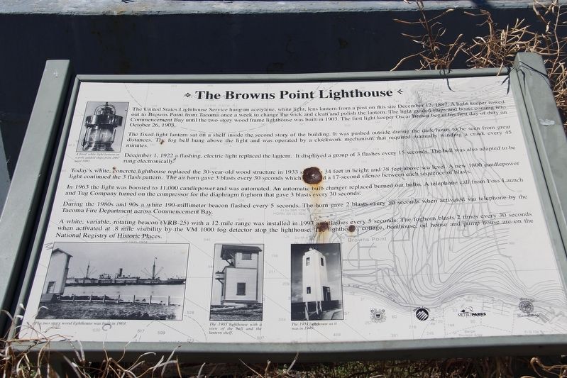
The fixed-light lantern sat on a shelf inside the second story of the building. It was pushed outside during the dark hours to be seen from great distances. The fog bell hung above the light and was operated by a clockwork mechanism that required manually winding a crank every 45 minutes.
December 1, 1922 a flashing, electric light replaced the lantern. It displayed a group of 3 flashes every 15 seconds. The bell was also adapted to be rung electronically.
Today's white, concrete lighthouse replaced the 30-year-old wood structure in 1933 stands 34 feet in height and 38 feet above sea level. A new 1800 candlepower light continued the 3 flash pattern. The air horn gave 3 blasts every 30
this page online
In 1963 the light was boosted to 11,000 candlepower and automated. An automatic bulb changer replaced burned out bulbs. A telephone call from Foss Launch and Tug Company turned on the compressor for the diaphragm foghorn that gave 3 blasts every 30 seconds.
During the 1980s and 90s a white 190-millimeter beacon flashed every 5 seconds. The horn gave 2 blasts every 30 seconds when activated via telephone by the Tacoma Fire Department across Commencement Bay.
A white, variable, rotating beacon (VRB-25) with a 12 mile range was installed in l997 and flashes every 5 seconds. The foghoren blasts 2 times every 30 secondswhen activated at .8 mile visibility by the VM 1000 fog detector atop the lighthouse. The lighthouse cottage, boathouse, oil house and pump house are on the National Registry of Historic Places.
[Captions (counterclockwise from top left)]
• A fixed, white light lantern on a pole guided ships from 1887 until 1903.
• The two story wood lighthouse was built in 1903.
• The 1903 lighthouse with a view of the bell and the lantern shelf.
• The 1933

Topics and series. This historical marker is listed in these topic lists: Communications • Waterways & Vessels. In addition, it is included in the Lighthouses series list. A significant historical date for this entry is October 26, 1903.
Location. 47° 18.355′ N, 122° 26.656′ W. Marker is in Tacoma, Washington, in Pierce County. It can be reached from Tulalip Street Northeast west of Wan-I-Da Avenue, on the right when traveling west. Marker is in Browns Point Lighthouse Park. Touch for map. Marker is at or near this postal address: 201 Tulalip St NE, Tacoma WA 98422, United States of America. Touch for directions.

Regionally, this marker is in the Puget Sound Region and in Greater Seattle. It is also on the American Pacific Coast, in the Pacific Northwest, and in the Lewis & Clark Corridor. Globally, it is in North America, in the Cascade Range, in the Inside Passage, on the Ring of Fire, on the Pacific Rim, in the Western Hemisphere, in the Western World, and in the Anglosphere.
Other nearby markers. At least 8 other markers are within walking distance of this marker: Generator Building (a few steps from this marker); Browns Point Light Station (within shouting distance of this marker); Captain George Vancouver at Browns Point (within shouting distance of this marker); The Browns Point Light Keeper's Cottage (within shouting distance of this marker); Light Keeper's Cottage (within shouting distance of this marker); Boat House and Oil House (within shouting distance of this marker); Crew Quarters (about 300 feet away, measured in a direct line); Bell and Pump House (about 400 feet away). Touch for a list and map of all markers in Tacoma.
Another marker is no longer nearby. The Browns Point Boat House and Oil House (was within shouting distance of this marker but has been replaced with another marker now near it).
Credits. This page was last revised on May 5, 2022. It was originally submitted on May 5, 2022, by Duane and Tracy Marsteller of Murfreesboro, Tennessee. This page has been viewed 311 times since then and 24 times this year. Photos: 1, 2. submitted on May 5, 2022, by Duane and Tracy Marsteller of Murfreesboro, Tennessee.
