Near Vineland in Mille Lacs County, Minnesota — The American Midwest (Upper Plains)
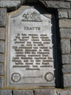
Izatys
Vineland Historical Marker
Photographed by Martha Decker, May 30, 2009
1. Izatys Marker
MNDOT Designation: Vineland Historical Marker
The settlement was visited by Father Hennepin in 1680. About 1750 the Chippewa moving westward from Lake Superior, captured the village, and by this decisive battle drove the Sioux permanently into southern Minnesota.
Erected 1952 by Minnesota Department of Highways (MHD). (Marker Number ML-KAN-006.)
Topics and series. This historical marker is listed in these topic lists: Exploration • Indigenous Peoples and Communities • Settlements & Settlers. In addition, it is included in the Minnesota Historical Society series list. A significant historical month for this entry is July 1863.
Location. 46° 9.8′ N, 93° 45.55′ W. Marker is near Vineland, Minnesota, in Mille Lacs County. It is at the intersection of U.S. 169 and Vineland Road, on the right when traveling north on U.S. 169. The marker is on the western shore of Mille Lacs Lake. The site is on the Mille Lacs Reservation and within Mille Lacs Kathio State Park. Touch for map. Marker is in this post office area: Onamia MN 56359, United States of America.
this page online

Regionally, this marker is in Central Minnesota. It is also in the American Midwest and in the Corn Belt. Globally, it is in North America, the Western Hemisphere, the Western World, and the Anglosphere. Historically, it finds itself in what was once Rupert’s Land, the territory of the Mississippian Culture, and the Northwest Territory.
Other nearby markers. At least 8 other markers are within walking distance of this marker: Water is Life (approx. 0.9 miles away); Medicine Garden (approx. 0.9 miles away); Mandaamin (approx. 0.9 miles away); Okosimaan (approx. 0.9 miles away); Meet the Three Sisters (approx. 0.9 miles away); Mashkodiisiminag (approx. 0.9 miles away); Harry & Jeannette Ayer House (approx. 0.9 miles away); Tourist Cottage (approx. 0.9 miles away). Touch for a list and map of all markers in Vineland.
More about this marker. According to MNDOT, prior to the erection of the stone marker, a 3' by 5' white steel sign with black lettering was at this site. It had been erected as early as 1930 by the first joint trunk highway marking program that was established by the Minnesota Historical
Photographed by Martha Decker, May 30, 2009
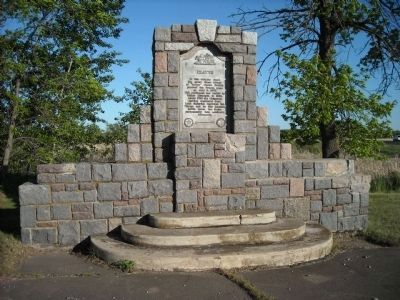
2. Izatys Marker
The current site was developed in 1952 by the Minnesota Department of Highways. The plans were drawn in February of 1952. Two stone and concrete benches originally in front of the marker are currently missing.
The granite for the marker was obtained from a quarry near Isle, a community located on the southeastern shore of Mille Lacs Lake.
Also see . . . Minnesota DOT page for this marker. Included on this page is a brief description of the marker and the history behind it. (Submitted on June 8, 2009, by Martha Decker of Shakopee, Minnesota.)
Additional keywords. Ojibwe Ojibway Dakota
Credits. This page was last revised on April 18, 2018. It was originally submitted on June 8, 2009, by Martha Decker of Shakopee, Minnesota. This page has been viewed 3,317 times since then and 104 times this year. Photos: 1, 2. submitted on June 8, 2009, by Martha Decker of Shakopee, Minnesota. • Kevin W. was the editor who published this page.
