
Teotihuacán de Arista in Teotihuacán, Mexico State, Mexico — The Central Highlands (North America)
Southern Building
Photographed by J. Makali Bruton, May 16, 2022
1. Southern Building Marker

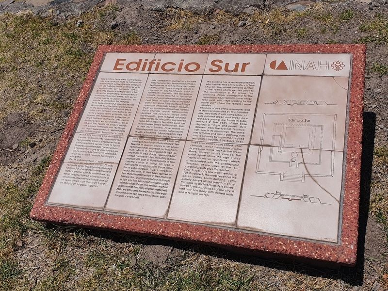
Este edificio tiene siete superposiciones que reflejan toda la historia de Teotihuacán. Los restos más antiguos son de habitaciones anteriores a la construcción del conjunto. Las siguientes etapas corresponden a basamentos piramidales superpuestos, orientados hacia el oeste, con escalinatas hacia la parte superior, en donde se ubicaban los templos. En la Subestructura 2, quedan restos de uno de estos templos y una escalinata delimitada por alfardas, decoradas con círculos concéntricos en verde y negro, sobre un fondo rojo. El cuerpo del basamento presenta un talud-tablero diferente del tipico teotihuacano en sus molduras. En el tablero hay restos de pintura mural, con cruces formadas por rectángulos rojos superpuestos, delimitados por lineas negras. En las cruces aparecen tres circulos concéntricos lla- mados "chalchihuites" que representan gotas de agua o cosas preciosas, como la piedra verde. Toda la figura forma el signo llamado "quincuncen" o "quinterno", que se asocia con los cinco rumbos del universo prehispá- nico: los cuatro rumbos cardinales y el centro.
De la Subestructura 1 sólo quedan vestigios de algunos muros. El más reciente de los basamentos, llamado Edificio Sur, cubre completamente a todas construcciones anteriores. Su estilo arquitectónico corresponde a las últimas fases de la ciudad: era de un solo cuerpo, con muros en talud y un templo en la parte superior.
Inin caltepantli quimpiya chicome tlanenepanoli tlen temachtia inemiliz in Teotihuacan. In flen cachto catcȧ maté chantoton flen omochiuhque cachto. In zatepan in flachichihualiz caté in flatetzontin teocaltin tlen flanenepa- lolcaté, ihuan ixflachá ic iquizayan tonatiuh, ihuanica temamatlattipan tlen cuali flèco, in 'canin cate in teocaltin. Ipan in tlen itoca Subestructura 2, zaye omocauh intlachaliz ininque teocaltin ihuan ce temamatlatl tlen tlami ica tlen itoca alfardas, mochi tlatlamachtli quipiya ica xoxoctic ihuan liltic flayehualoltin, ipan in tlapali chichiltic. In tlen mochi in caltecpantli quipiya tlen itoca talud-tablero flen àmo cuali zan mochihuaya ompa teotihuacan. Ipan in tlen itoca tablero, zaye mohta in tlapaltepamitl, ica croztic flatlamachtli ihuan chichiltic nànauhpantli tlen monenepanohua ihuan tlayecohuaica tliltic flamelahualiztli. Ipan in canin neci croztique flen itoca "chalchihuites" tlen teixtitia in quenin chipini in atl onozo tetlatlamachtli, in quenin in chalchichihuitl. Mochi in flacuicuilolíztli tlen temachtiliztli tlen itoca "quincuncen" onozo "quintero", tlen mocetilia ipan in macuili otli ipan in flaneltoquiliz in flen cachto catca: in nahui òtli ipan in tlalticpactli ihuan in yolòtli. Ihuan in tlen itoca Subestructura 1 zaye mocahua cequi tepantin. In tlen zaye quinye in tlen mochi basamentos, in tlen motoca Edificio Sur, quintlapachohua in mocha in flen cachto omochiuh in caltecpan- chichihualizfli. Ihuan in quenin omochiuh cuali momatitlen inin yetlamia in altepetl; zan ce caltepantli tlanechicoli, ica cequi tepantin ipan flen itoca talud ihuan ipan flacpac ce teocalli.
Southern Building
This building has seven superpositions which reflect the entire history of Teotihucán. The oldest remains pertain to the rooms which existed prior to the construction of the group. The following stages correspond to the superimposed pyramidal bases which face west, with steps leading to the upper part where the temples were situated.
Remains of one of these temples and a stairway bounded by low balustrades, decorated with concentric circles painted green and black on a red background, are found in Substructure 2. The body of the base displays a "slope and panel" style different from the typical Teotihuacán one in its mouldings. The panel has remains of a mural painting with crosses formed by superimposed red rectangles bounded by black lines. Three concentric circles called "chalchihuites", which mean drops of water or precious things, such as the green stone, appear in the crosses. The entire figure forms the sign called "quincuncen" or "quinterno", which is associated with the prehispanic directions of the universe: the four cardinal points plus the center.
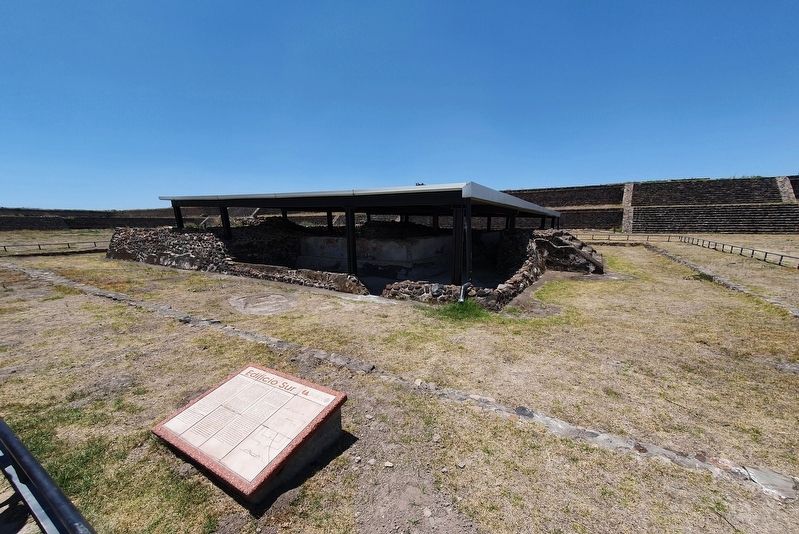
Only traces of a few walls remain of Substructure 1. The most recent of the bases, called South Building, completely covers all the previous constructions. Its architectual style corresponds to the last phases of the city: it had only one body with sloped walls and a temple on top.
Erected by Instituto
this page online
Topics. This historical marker is listed in these topic lists: Anthropology & Archaeology • Architecture.
Location. 19° 40.894′ N, 98° 50.847′ W. Marker is in Teotihuacán de Arista, Estado de Mexico (Mexico State), in Teotihuacán. It is on Calzada de los Muertos just east of Route 132, on the right when traveling north. Touch for map. Marker is in this post office area: Teotihuacán de Arista MEX 55825, Mexico. Touch for directions.

Regionally, this marker is in Central Mexico and specifically in Mexico City Metropolitan Area. Globally, it is in North America, specifically in Mesoamerica, on the Ring of Fire, and in the Western Hemisphere. Historically, it finds itself in what was once New Spain, a Spanish colony, and the Aztec Empire.
Other nearby markers. At least 8 other markers are within walking distance of this marker: The Southern Building of Teotihuacan (here, next to this marker); Embedded Platform (within shouting distance of this marker); Temple of the Plumed Serpent (about 90 meters away, measured in a direct line); La Ciudadela
Photographed by J. Makali Bruton, May 16, 2022
2. Southern Building Marker

Photographed by J. Makali Bruton, May 16, 2022
3. Southern Building
Credits. This page was last revised on May 1, 2024. It was originally submitted on June 2, 2022, by J. Makali Bruton of Washington, District of Columbia. This page has been viewed 252 times since then and 13 times this year. Photos: 1, 2, 3. submitted on June 2, 2022, by J. Makali Bruton of Washington, District of Columbia.
