Near Denton in Caroline County, Maryland — The American Northeast (Mid-Atlantic)
The Food Sources of Enslaved Afro-Marylanders

Photographed By Devry Becker Jones (CC0), June 3, 2022
1. The Food Sources of Enslaved Afro-Marylanders Marker
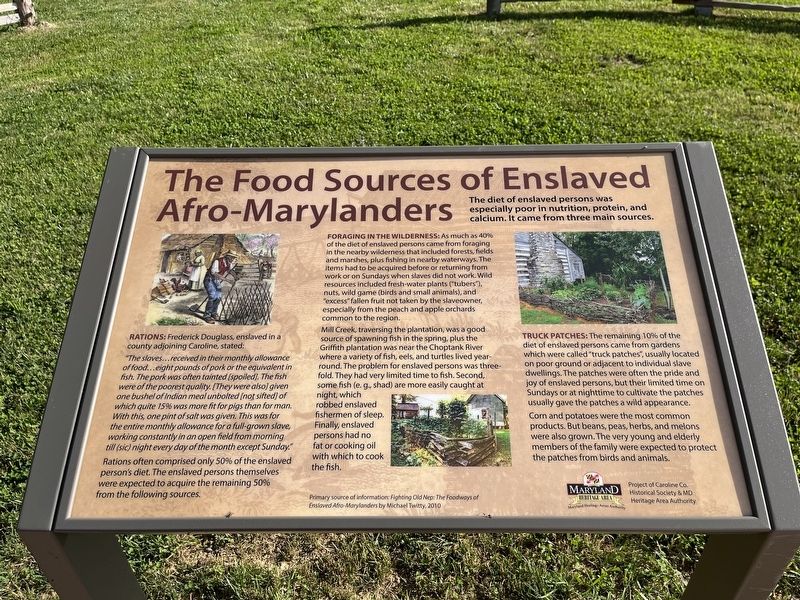
The diet of enslaved persons was especially poor in nutrition, protein, and calcium. It came from three main sources.
Rations: Frederick Douglass, enslaved in a county adjoining Caroline, stated:
"The slaves…received their monthly allowance of food…eight pounds of pork or the equivalent in fish. The pork was often tainted [spoiled]. The fish were of the poorest quality. [They were also] given one bushel of Indian meal unbolted [not sifted] of which quite 15% was more fit for pigs than for man. With this, one ping of salt was given. This was for the entire monthly allowance for a full-grown slave, working constantly in an open field from morning till (sic) night every day of the month except Sunday."
Rations often comprised only 50% of the enslaved person's diet. The enslaved persons themselves were expected to acquire the remaining 50% from the following sources.
Foraging in the wilderness: as much as 40% of the diet of enslaved persons came from foraging in the nearby wilderness that included forests, fields and marshes, plus fishing in nearby waterways. The items had to be acquired before returning from work or on Sundays when the slaves did not work. Wild resources included fresh-water plants ("tubers"), nuts, wild game (birds and small animals), and "excess" fallen fruit not taken by the slaveowner, especially from the peach and apple orchards common to the region.
Mill Creek, traversing the plantation, was a good source of spawning fish in the spring, plus the Griffith plantation was near the Choptank River where a variety of fish, eels, and turtles lived year-round. The problem for enslaved persons was three-fold. They had very limited time to fish. Second, some fish (e.g., shad) are more easily caught at night, which robbed enslaved fishermen of sleep. Finally, enslaved persons had no fat or cooking oil with which to cook the fish.
Truck patches: The remaining 10% of the diet of enslaved persons came from gardens which were called "truck patches", usually located on poor ground or adjacent to individual slave dwellings. The patches were often the pride and joy of enslaved persons, but their limited time on Sundays or at nighttime to cultivate the patches usually gave the patches a wild appearance.
Corn and potatoes were the most common products. But beans, peas, herbs, and melons were also grown. The very young and elderly members of the family were expected to protect the patches from birds and animals.
Primary source of information: Fighting Old Nep: The Foodways

Photographed By Devry Becker Jones (CC0), June 3, 2022
2. The Food Sources of Enslaved Afro-Marylanders Marker
Erected by Maryland Heritage Area Authority; project of Caroline Co. Historical Society & MD Heritage Area Authority.
Topics. This historical marker is listed in these topic lists: African Americans • Agriculture • Animals • Anthropology & Archaeology. A significant historical year for this entry is 2010.
Location. 38° 49.975′ N, 75° 50.157′ W. Marker is near Denton, Maryland, in Caroline County. Marker can be reached from Detour Road east of Harmony Road (Maryland Route 16), on the right when traveling east. Touch for map. Marker is at or near this postal address: 8230 Detour Rd, Denton MD 21629, United States of America. Touch for directions.
Other nearby markers. At least 8 other markers are within walking distance of this marker. William Still: "Father of the Underground Railroad" (a few steps from this marker); Peter Still: The Kidnapped and the Ransomed (a few steps from this marker); Sydney Still: "Sydney's Choice" (a few steps from this marker); The Doncaster Dwelling: A Perfect Substitute (within shouting distance of this marker); White Tenant Farmers (within shouting distance of this marker); Early Commercial Agriculture (within shouting distance of this marker); Edmondson's Reserve (within shouting distance of this marker); William Still Center (about 300 feet away, measured in a direct line). Touch for a list and map of all markers in Denton.
Additional commentary.
1. About Mike Twitty
The source for this marker's information is Michael "Mike" Twitty, who is a respected culinary historian from Maryland, with expertise in both African American an Jewish American culinary history. His first book on African American culinary history, The Cooking Gene: A Journey Through African American Culinary History in the Old South, was published in 2018. He also runs a blog called Africulinaria. Twitty has also been interviewed by the Washington Post and National Public Radio multiple times.
— Submitted June 4, 2022, by Devry Becker Jones of Washington, District of Columbia.
Credits. This page was last revised on June 4, 2022. It was originally submitted on June 4, 2022, by Devry Becker Jones of Washington, District of Columbia. This page has been viewed 214 times since then and 22 times this year. Photos: 1, 2. submitted on June 4, 2022, by Devry Becker Jones of Washington, District of Columbia.