Fort Norfolk , Virginia — The American South (Mid-Atlantic)
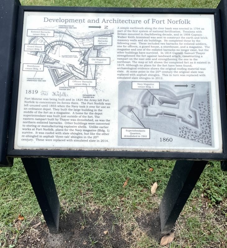
Development and Architecture of Fort Norfolk
Inscription.
A simple earthwork along the river bank was erected in 1794 as part of the first system of national fortification. Tensions with Britain mounted in the following decade, and in 1808 Captain Walker Keith Armistead was sent to construct the earth and brick masonry walls and six buildings. He completed these by the following year. These included two barracks for enlisted soldiers, one for officers, a guard house, a storehouse, and a magazine. The magazine and one of the enlisted barracks no longer exist, but the other buildings have survived. In 1814 Captain Samuel Thayer strengthened the fort against landward attack, constructing a rampart on the east side and strengthening the one to the northeast. The map at left shows the completed fort as it existed in 1819. Although no plans for the fort have been found, archaeological evidence shows the original roofing material was slate. At some point in the 20th century the original slate was replaced with asphalt shingles. This in turn was replaced with simulated slate shingles in 2012.
Fort Monroe was being built and in 1824 the Army left Fort Norfolk to concentrate its forces there. The Fort Norfolk was left unused until 1855 when the Navy took it over for use as an ordnance depot. They built the large building in the middle of the fort as a magazine. A home for the depot superintendant (sic) was built just outside of the fort. The eastern rampart built by Thayer was demolished, as was the northern enlisted barracks. Other buildings were converted to storing or manufacturing explosive shells. Unlike earlier works at Fort Norfolk, plans for the Navy magazine (Bldg. 1) survive. It was roofed with slate shingles, but like the other re-shingled in asphalt 'three-tab' shingles in the 20th century. These were replaced with simulated slate in 2014.
Erected by Norfolk Historical Society.
Topics. This historical marker is listed in these topic lists: Anthropology & Archaeology • Forts and Castles • War of 1812.
Location. 36° 51.394′ N, 76° 18.373′ W. Marker is in Norfolk, Virginia. It is in Fort Norfolk. Marker can be reached from Front Street west of Colley Avenue when traveling west. Touch for map. Marker is at or near this postal address: 801 Front Street, Norfolk VA 23510, United States of America. Touch for directions.
Other nearby markers. At least 8 other markers are within walking distance of this marker. Fort Norfolk Veterans of the War of 1812 Memorial (a few steps from this marker); Fort Norfolk, 1810 (within shouting distance of this marker); Welcome to Historic Fort Norfolk (about 500 feet away, measured in a direct line); a different marker also named Fort Norfolk (about 700
feet away); a different marker also named Fort Norfolk (approx. 0.2 miles away); Atlantic City (approx. 0.2 miles away); a different marker also named Welcome to Historic Fort Norfolk (approx. 0.2 miles away); Elizabeth River Restoration (approx. ¼ mile away). Touch for a list and map of all markers in Norfolk.
Also see . . .
1. Fort Norfolk (Norfolk, Virginia). Wikipedia entry (Submitted on November 23, 2022, by Larry Gertner of New York, New York.)
2. Norfolk Historical Society. Society website homepage (Submitted on June 20, 2022, by Brandon D Cross of Flagler Beach, Florida.)
Credits. This page was last revised on February 1, 2023. It was originally submitted on June 20, 2022, by Brandon D Cross of Flagler Beach, Florida. This page has been viewed 103 times since then and 17 times this year. Photos: 1, 2. submitted on June 20, 2022, by Brandon D Cross of Flagler Beach, Florida. • Bernard Fisher was the editor who published this page.

