Ocala in Marion County, Florida — The American South (South Atlantic)
The Seminole War
Fort King National Historic Landmark
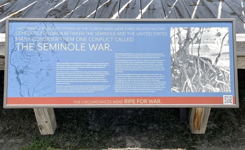
The Seminole Wars, also known as the Florida Wars, were three related military conflicts in Florida between the Seminole and the United States. Many consider them one conflict called The Seminole War.
There is no absolute consensus to the beginning and ending dates of the Seminole War; however, most historians have settled on a range of 1816 to 1858. It was a lengthy conflict aggravated by broken promises and failed negotiations spanning more than four decades.
The reasons cited for the Seminole War are many, but most agree that the United States government desired to have control of Florida for reasons related to defense and commerce. American settlers desired to expand into the Florida territory which created conflicts with the Seminole who were there long before them. Because the Spanish government, who owned the land, had outlawed slavery in Florida, this land also had become a sanctuary for escaped slaves who crossed the border to take refuge.
This was an unsettled territory. Not merely in terms of "ready to be settled” but more in terms of unrest. Property rights were largely ignored, multiple languages were spoken, the Spanish government didn’t have a strong hold and the American government would take what wouldn’t be given voluntarily.
The American expansion into the Spanish-controlled Florida peninsula had begun in the 1700s. Several attempts by American patriots to gain control of the territory, in what is known as the Patriot Wars of East Florida, had failed.
Florida officially became American territory in 1821 and the conflict between the U.S. and the Seminole began to escalate again shortly thereafter. To alleviate tensions, the U.S. government decided to move the Seminole to a reservation. Eventually a deal was struck with the Treaty of Moultrie Creek in 1823. The U.S. government enforced the treaty by building forts in the territory, and an Indian Agent located near Fort King worked as a liaison between the Seminole and the government.
It is important to note that even the years in between the three distinct “war years” were rife with tension and conflict. This explains why so many consider this one war, not three. The war on the Seminole extended so long for many reasons. The Seminole were masters of guerrilla warfare and had the advantage of familiarity with the land. This was, after all, their land. The U.S. Army lacked funding and other resources and were otherwise disadvantaged by a constant changing of leadership and strategy. On top of this, the soldiers could never acclimate to the oppressive florida summer climate, thus the troops had to he called back over the summer causing them to lose any ground they had gained over the previous winter. This allowed the Seminole time to regroup and strategize.
Erected by Florida Department of State/Division of Historical Resources.
Topics. This historical marker is listed in these topic lists: Forts and Castles • Native Americans • Settlements & Settlers • Wars, US Indian. A significant historical year for this entry is 1816.
Location. 29° 11.234′ N, 82° 4.957′ W. Marker is in Ocala, Florida, in Marion County. Marker can be reached from the intersection of East Fort King Street and SE 39th Terrace, on the left when traveling east. Marker is located on the grounds of the Fort King National Historic Landmark. Touch for map. Marker is at or near this postal address: 3925 E Fort King St, Ocala FL 34470, United States of America. Touch for directions.
Other nearby markers. At least 8 other markers are within walking distance of this marker. The First Seminole War (here, next to this marker); The Second Seminole War / The Third Seminole War (here, next to this marker); A Tale of Two Forts (a few steps from this marker); The Second Fort (a few steps from this marker); Fort King (a few steps from this marker); Fort King Road (a few steps from this marker); The U.S. Army on the frontier (within shouting distance of this marker); It was a Hard Life at Fort King (within shouting distance of this marker). Touch for a list and map of all markers in Ocala.
Also see . . . The Seminole Wars. Seminole Nation Museum website entry (Submitted on July 5, 2022, by Brandon D Cross of Flagler Beach, Florida.)
Credits. This page was last revised on February 17, 2023. It was originally submitted on July 5, 2022, by Brandon D Cross of Flagler Beach, Florida. This page has been viewed 72 times since then and 9 times this year. Photos: 1, 2. submitted on July 5, 2022, by Brandon D Cross of Flagler Beach, Florida. • Bernard Fisher was the editor who published this page.

