
Near Chase City in Mecklenburg County, Virginia — The American South (Mid-Atlantic)
Mount Horeb Church
Confederate “enraged birds”
| — | Wilson-Kautz Raid | — |
Photographed by Bernard Fisher, June 21, 2009
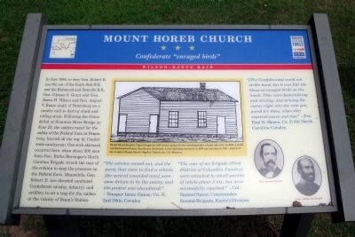
1. Mount Horeb Church CWT Marker
(sidebar)
Mount Horeb Baptist Church began in 1855 with a group of men meeting under a large oak tree. In 1858, a small weatherboarded frame church was dedicated. A new building was built in 1890 and another in 1914 – a sketch of the original Mount Horeb Baptist Church, by C.P. Johnson.
“The column moved out, and the party that went to find a vehicle [for several wounded men] were soon driven in by the enemy, and the project was abandoned.”
this page online
“The rear of my brigade (First District of Columbia Cavalry) were attacked by small parties of rebels about 5 P.M., but were successfully repulsed.” - Col. Samuel Spear, Commander, Second Brigade, Kautz's Division
“[The Confederates] could not strike hard, but it was like the blows of enraged birds on the hawk. They were demoralizing and driving. And driving the enemy right into the ruin prepared for them, when they expected peace and rest.” - Pvt. Paul B. Means, Co. F, 5th North Carolina Cavalry
Erected by Virginia Civil War Trails.
Topics and series. This historical marker is listed in these topic lists: Religion & Religious Structures • War, US Civil. In addition, it is included in the Virginia Civil War Trails series list. A significant historical month for this entry is June 1864.
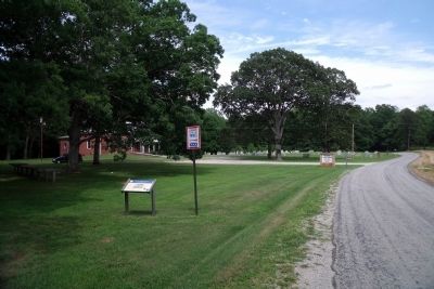
Location. 36° 48.075′ N, 78° 18.947′ W. Marker is near Chase City, Virginia, in Mecklenburg County. It is on Old Cox Road 0.1 miles east of Meadows Road, on the left when traveling east. Touch for map. Marker is in this post office area: Chase City VA 23924, United States
Photographed by Bernard Fisher, June 21, 2009
2. Old Cox Road (facing east).

Regionally, this marker is in Southern Virginia, specifically in the Piedmont, in Southside Virginia, and specifically in Central Virginia. It is also in the American South and specifically in the Upper South. Globally, it is in North America, the Western Hemisphere, the Western World, and the Anglosphere. Historically, it finds itself in what was once the territory of the Mississippian Culture, one of the original Thirteen Colonies, one of the Confederate States of America, and the Antebellum South.
Other nearby markers. At least 8 other markers are within 10 miles of this marker, measured as the crow flies: Lunenburg County / Mecklenburg County (approx. 7.2 miles away); Christiansville (approx. 7.9 miles away); Sgt. Earle D. Gregory (approx. 8 miles away); Thyne Institute (approx. 8.6 miles away); a different marker also named Thyne Institute (approx. 8.7 miles away); The Boyd Tavern (approx. 9.8 miles away); Boydton and Petersburg Plank Road (approx. 9.9 miles away); Boydton Presbyterian Church (approx. 10 miles away). Touch for a list and map of all markers in Chase City.
Another marker is no longer nearby. Thyne Institute (was approx. 8.7 miles away but has been replaced with another marker now near it).
Regarding Mount Horeb Church. In the center sidebar is "a sketch of the original Mount Horeb Baptist Church, by C.P. Johnson." On the lower right are porttraits of "Col. Samuel Spear" and "Gen. Rufus Barringer"
Credits. This page was last revised on November 10, 2021. It was originally submitted on June 22, 2009, by Bernard Fisher of Richmond, Virginia. This page has been viewed 1,953 times since then and 39 times this year. Photos: 1, 2. submitted on June 22, 2009, by Bernard Fisher of Richmond, Virginia.
