National Harbor in Fort Washington in Prince George's County, Maryland — The American Northeast (Mid-Atlantic)
Neighbor to the Nation's Capital
Photographed by Devry Becker Jones (CC0), December 22, 2018
1. Neighbor to the Nation's Capital Marker
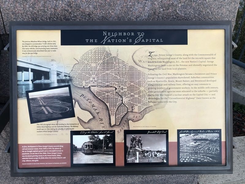
In 1790, Prince George's County, along with the Commonwealth of Virginia, relinquished most of the land for the ten-mile square that would become Washington, D.C., the new Nation's Capital. George Washington chose a site on the Potomac and shrewdly negotiated the best price for land from local planters.
Following the Civil War, Washington became a boomtown and Prince George's County's population skyrocketed. Suburban communities such as Hyattsville, Bowie, Mount Rainer, and Brentwood developed along streetcar and railway lines, offering an easy commute to growing numbers of government workers. In the middle 20th century, many government agencies were relocated to the suburbs — partially due to Cold War fears of a nuclear attack on the Capital City — and plans began for the "Circumferential Highway" (later known as the Beltway) to encircle the City.
[Captions:]
The previous Woodrow Wilson Bridge, built in 1961, was designed to accommodate 75,000 vehicles daily. By 2006, the old bridge was carrying over three times that many vehicles, and frustrating many commuters. It was ceremoniously demolished that year to make way for the new bridge.
This 1962 photograph shows the cloverleaf at the intersection of Indian Head Highway and the unfinished Beltway. The Beltway would open in 1964, linking the suburbs of northern and southern Prince George's County.
At first development in Prince George's County occurred along rail and streetcar routes. From 1930 to 1970, the advent of the car brought explosive growth and an elevenfold increase in population. At one time in the 1960s, Prince George's County was the fastest growing county in the United States. Today, suburban homes occupy the fields where the county's historic cash crop, tobacco, once grew.
Topics.
this page online
Location. 38° 47.56′ N, 77° 1.457′ W. Marker is in Fort Washington, Maryland, in Prince George's County. It is in the National Harbor. It can be reached from Capital Beltway (Interstate 95) west of National Harbor Boulevard. Touch for map. Marker is in this post office area: Oxon Hill MD 20745, United States of America. Touch for directions.

Regionally, this marker is in the Washington Metropolitan Area. It is also in the American South, specifically in the Upper South, in the Mid-Atlantic, and on the Eastern Seaboard. Globally, it is in the North Atlantic Region, North America, the Western Hemisphere, the Western World, and the Anglosphere. Historically, it finds itself in what was once one of the original Thirteen Colonies and also the Antebellum South.
Other nearby markers. At least 8 other markers are within walking distance of this marker: The Founding of Maryland (here, next to this marker); The Tobacco Economy (here, next to this marker);
Photographed by Devry Becker Jones (CC0), December 22, 2018
2. Neighbor to the Nation's Capital Marker
Credits. This page was last revised on March 3, 2023. It was originally submitted on December 23, 2018, by Devry Becker Jones of Washington, District of Columbia. This page has been viewed 303 times since then and 20 times this year. Last updated on July 25, 2022, by Carl Gordon Moore Jr. of North East, Maryland. Photos: 1, 2. submitted on December 23, 2018, by Devry Becker Jones of Washington, District of Columbia.
