Fort Washington in Prince George's County, Maryland — The American Northeast (Mid-Atlantic)
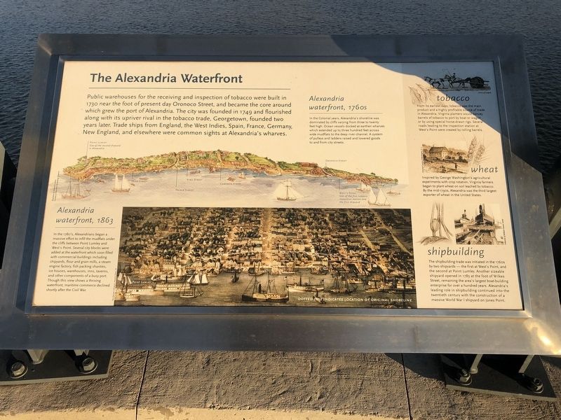
The Alexandria Waterfront
Public warehouses for the receiving and inspection of tobacco were built in 1730 near the foot of present day Oronoco Street, and became the core around which grew the port of Alexandria. The city was founded in 1749 and flourished along with its upriver rival in the tobacco trade, Georgetown, founded two years later. Trade ships from England, the West Indies, Spain, France, Germany, New England, and elsewhere were common sights at Alexandria's wharves.
Point Lumley
Site of the second shipyard in Alexandria
West's Point
Site of the first tobacco inspection station and the first shipyard
Alexandria waterfront, 1760s
In the Colonial years, Alexandria's shoreline was dominated by cliffs varying from three to twenty feet high. Ocean vessels docked at earthen wharves which extended up to three hundred feet across wide mudflats to the deep river channel. A system of pulleys and ladders raised and lowered goods to and from city streets.
Alexandria waterfront, 1863
In the 1780's, Alexandrians began a massive effort to infill the mudflats under the cliffs between Point Lumley and West's Point. Several city blocks were added at the waterfront which soon filled with commercial buildings including shipyards, flour and grain mills, a steam engine factory, fish packing shanties, ice houses, warehouses, inns, taverns, and other components of a busy port. Though this view shows a thriving waterfront, maritime commerce declined shortly after the Civil War.
tobacco
From its earliest days, tobacco was the main product and a highly profitable source of trade in Alexandria. Virginia planters would convey barrels of tobacco to port by boat or wagon or by using special horse-drawn rigs. Several roads leading to the inspection station at West's Point were created by rolling barrels.
wheat
Inspired by George Washington's agricultural experiments with crop rotation, Virginia farmers began to plant wheat on soil leached by tobacco. By the mid-1790s, Alexandria was the third largest exporter of wheat in the United States.
shipbuilding
The shipbuilding trade was initiated in the 1760s by two shipyards — the first at West's Point, and the second at Point Lumley. Another sizeable shipyard opened in 1783 at the foot of Wilkes Street, remaining the area's largest boat-building enterprise for over a hundred years. Alexandria's leading role in shipbuilding continued into the twentieth century with the construction of a massive World War I shipyard on Jones Point.
Topics. This historical marker is listed in these topic lists: Agriculture
Location. 38° 47.591′ N, 77° 1.844′ W. Marker is in Fort Washington, Maryland, in Prince George's County. Marker is on Woodrow Wilson Memorial Bridge (Interstate 95) west of National Harbor Boulevard, on the right when traveling west. Touch for map. Marker is in this post office area: Oxon Hill MD 20745, United States of America. Touch for directions.
Other nearby markers. At least 8 other markers are within walking distance of this marker. Woodrow Wilson Memorial Bridge (approx. 0.3 miles away); A New Nation's Capital (approx. 0.3 miles away); Crossing the River (approx. 0.3 miles away); Two Worlds Meet in the Summer of 1608. (approx. 0.3 miles away); Working to Improve the River (approx. 0.3 miles away); Potomac Fisheries (approx. 0.3 miles away); The Nation's River (approx. 0.3 miles away); Bladensburg (approx. 0.3 miles away). Touch for a list and map of all markers in Fort Washington.
Credits. This page was last revised on March 3, 2023. It was originally submitted on December 23, 2018, by Devry Becker Jones of Washington, District of Columbia. This page has been viewed 162 times since then and 19 times this year. Last updated on July 26, 2022, by Carl Gordon Moore Jr. of North East, Maryland. Photos: 1, 2. submitted on December 23, 2018, by Devry Becker Jones of Washington, District of Columbia.

