Manchester in Richmond, Virginia — The American South (Mid-Atlantic)
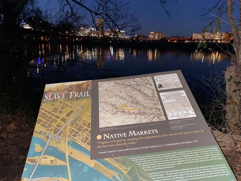
Native Markets
— Richmond Slave Trail —
"Virginia will gain by stopping the importations. Her slaves will rise in value, & she has more than she wants."
-General Charles Cotesworth Pinckney of South Carolina, U.S. Constitutional Convention, 1787
During the more than ninety years of active Trans-Atlantic Trade of enslaved Africans to colonists, plantation owners, and traders purchased roughly 114,000 Africans from the Atlantic slaving brigs. Most of the early sales took place along the banks of the York, Potomac, and Rappahannock rivers or in nearby towns. A few ships traveled up the James River, but after 1746 forty percent of the enslaved Africans in Virginia were brought to Bermuda Hundred where the James and the Appomattox Rivers converge and Osborne's Landing a few miles farther up the James River. From there, smaller vessels could navigate nearly thirty miles of twisting waterways to Petersburg and Richmond.
Until the time of the American Revolution, Richmond was a small collection of villages situated at the Falls of the James. The earliest sales and auctions that took place in this area, including Petersburg, were most likely secondary sales of captives that had been purchased elsewhere. Rocky Ridge, now known as Manchester, and Richmond were both advertised points of sale during the 1760s and ... enslaved Africans who had been born in Virginia or who had lived in Virginia ...
About the Trail
Designed as a walking path, the Richmond Slave Trail chronicles the history of the trade in enslaved Africans from their homeland to Virginia until 1778, and away from Virginia, especially Richmond, to other locations in the Americas until 1865. The trail begins at the Manchester Docks, which, alongside Rocketts Landing on the north side of the river, operated as a major port in the massive downriver slave trade, making Richmond the largest source of enslaved blacks on the east coast of America from 1830 to 1860. While many of the slaves were shipped on to New Orleans and to other Deep South ports, the trail follows the footsteps of those who remained here and crossed the James River, often chained together in a coffle. Once reaching the northern riverbank, the trail then follows a route through the slave markets and auction houses of Richmond, beside the Reconciliation Statue commemorating the international triangular slave trade and on to the site of the notorious Lumpkin’s Slave Jail and leading on to Richmond’s African Burial Ground, once called the Burial Ground for Negroes, and the First African Baptist Church, a center of African American life in pre-Civil War Richmond. - Richmond Slave Trail Commission – 2011 –
Erected 2011 by Richmond Slave Trail Commission. (Marker Number 5.)
Topics. This historical marker is listed in these topic lists: African Americans • Colonial Era • Industry & Commerce • Settlements & Settlers. A significant historical year for this entry is 1746.
Location. 37° 31.486′ N, 77° 25.583′ W. Marker is in Richmond, Virginia. It is in Manchester. Marker can be reached from Brander Street east of Maury Street, on the left when traveling east. The Richmond Slave Trail begins at Ancarrow's Landing (1200 Brander St). Marker #5 is 0.5 mile along the trail. Touch for map. Marker is at or near this postal address: 1200 Brander St, Richmond VA 23224, United States of America. Touch for directions.
Other nearby markers. At least 8 other markers are within walking distance of this marker. Slavery Challenged (approx. 0.2 miles away); Creole Revolt (approx. 0.2 miles away); Water Quality in the James (approx. 0.2 miles away); Here Stood the Trigg Shipyard (approx. ¼ mile away); The Tidal James (approx. ¼ mile away); Norfolk and Southern Bridge (approx. ¼ mile away); Welcome to Chapel Island (approx. ¼ mile away); Richmond Dock / Chapel Island (approx. 0.3 miles away). Touch for a list and map of all markers in Richmond.
Credits. This page was last revised on February 1, 2023. It was originally submitted on July 29, 2022, by Lou Donkle of Valparaiso, Indiana. This page has been viewed 147 times since then and 45 times this year. Photo 1. submitted on July 29, 2022, by Lou Donkle of Valparaiso, Indiana. • Bernard Fisher was the editor who published this page.
Editor’s want-list for this marker. Wide shot of marker and its surroundings. • Can you help?
