Near Pocahontas in Yellowhead County, Alberta — Canada’s Prairie Region (North America)
Yellowhead / Tête Jaune
Alberta's History
In the early 1800s both the North West and Hudson's Bay companies recruited men from Iroquois settlements around Montreal, Quebec, and Cornwall, Ontario, to work as canoemen, hunters and trappers. Their skills in these occupations gave them an important role in the fur trade in northern Alberta and the Rocky Mountains.
According to fur trade company records, Pierre Bostonais, an Iroquois nicknamed Tête Jaune (Yellowhead), was living on the upper Peace River as early as 1816. His last name suggests that he or his family may have come from the United States. His nickname suggests that he had light-coloured hair, leading some to speculate that he was of mixed European and Iroquois ancestry.
Pierre and his brother, Baptiste, helped a group of Hudson's Bay Company employees explore a new route to the interior of British Columbia in 1825. The pass that they used came to be called the Yellowhead Pass, after Pierre. Later that year, fur trade records mention Tête Jaune's Cache, the place where Bostonais stored his furs and supplies. Pierre and Baptiste spent the next two years living among the Carrier Indians of the Fort St. James area. In 1827, they moved northeast to Finlay River and soon got involved in a conflict with the local Aboriginal people. Hudson's Bay Company records report that they were killed in September as punishment for hunting on other peoples' lands. Little else is known of Yellowhead's life, but his role in the history of this region is commemorated by Yellowhead Pass, Tête Jaune Cache, and this highway - the Yellowhead.
Erected by Alberta Historical Resources Foundation.
Topics. This historical marker is listed in these topic lists: Exploration • Industry & Commerce • Native Americans • Roads & Vehicles. A significant historical year for this entry is 1825.
Location. 53° 14.346′ N, 117° 47.652′ W. Marker is near Pocahontas, Alberta, in Yellowhead County. Marker is on Yellowhead Highway (Provincial Highway 16) 16.3 kilometers west of Provincial Highway 40, on the right when traveling west. Marker is located in the Folding Mountain West Rest Area, about 3 km east of Jasper National Park. Touch for map. Marker is in this post office area: Pocahontas AB T0E 0C0, Canada. Touch for directions.
Other nearby markers. At least 1 other marker is within 16 kilometers of this marker, measured as the crow flies. Jasper House (approx. 16 kilometers away).
Also see . . .
1. Tête Jaune.
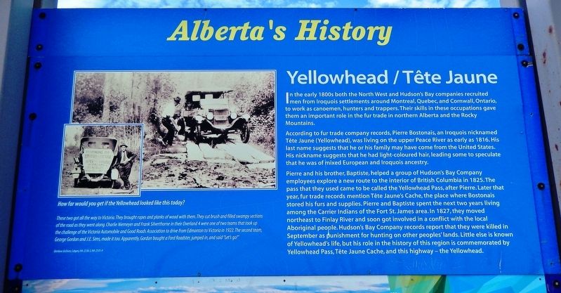
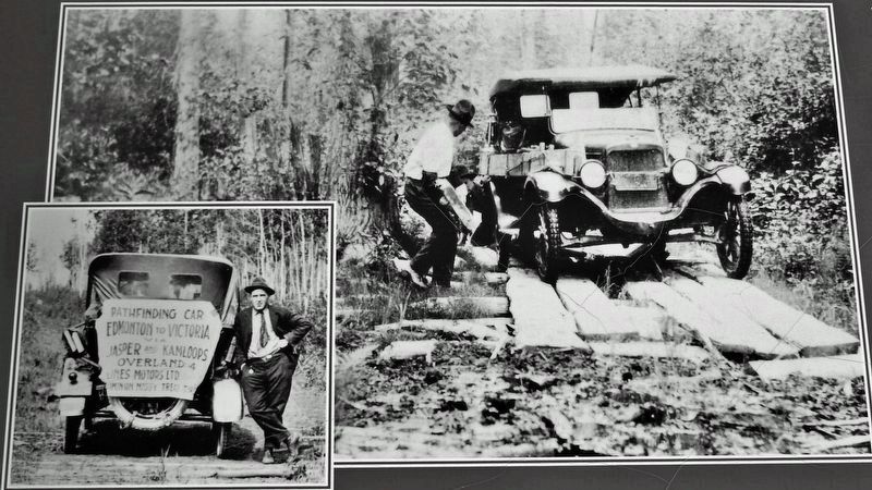
Pierre Bostonais or Pierre Hastination, better known as Tête Jaune, was an Iroquois-Métis trapper, fur trader, and explorer who worked for the North West Company and Hudson's Bay Company during(Submitted on August 11, 2022, by Cosmos Mariner of Cape Canaveral, Florida.)the 18th and 19th centuries. In the early 19th century, Pierre crossed the Rocky Mountains by the pass that would later bear his name. He led a brigade of Hudson's Bay men through the same pass in December 1819.Glenbow Archives, Calgary, NA-2336-2, NA-2335-42. Marker detail: How far would you get if the Yellowhead looked like this today?These two got all the way to Victoria. They brought ropes and planks of wood with them. They cut brush and filled swampy sections of the road as they went along. Charlie Niemeyer and Frank Silverthorne in their Overland 4 were one of two teams that took up the challenge of the Victoria Automobile and Good Roads Association to drive from Edmonton to Victoria in 1922. The second team, George Gordon and J.E. Sims, made it too. Apparently, Gordon bought a Ford Roadster, jumped in, and said "Let's go!"
2. Tête Jaune Cache, British Columbia.
Tête Jaune Cache is an unincorporated rural area and the site of an important abandoned historic town in British Columbia. It is located on the Fraser River in the Robson Valley at the intersection of Yellowhead Highways 5 and 16. During the construction of the Grand Trunk Pacific Railway Tête Jaune Cache was a booming collection of lumber shacks, tents, and log houses which brought thousands of pioneers, trappers, prospectors, foresters, and entrepreneurs to the Robson Valley. The pool halls, theatres, restaurants, jewelers, lady barbers, saloons, and trading posts are no more, with only a few stone chimneys remaining as evidence of this bustling town's existence.(Submitted on August 11, 2022, by Cosmos Mariner of Cape Canaveral, Florida.)
3. Yellowhead Highway.
The Yellowhead Highway is a major interprovincial highway in Western Canada that runs from Winnipeg to Graham Island off the coast of British Columbia via Saskatoon and Edmonton. It stretches across the four western Canadian provinces of British Columbia, Alberta, Saskatchewan, and Manitoba. The highway is named for the Yellowhead Pass, the route chosen to cross the Canadian Rockies. Almost the entire length of the highway is numbered as 16, except for the section in Manitoba that is concurrent with Trans-Canada Highway 1.(Submitted on August 11, 2022, by Cosmos Mariner of Cape Canaveral, Florida.)
Credits. This page was last revised on August 12, 2022. It was originally submitted on August 11, 2022, by Cosmos Mariner of Cape Canaveral, Florida. This page has been viewed 217 times since then and 48 times this year. Photos: 1, 2, 3. submitted on August 11, 2022, by Cosmos Mariner of Cape Canaveral, Florida.


