Columbia in Monroe County, Illinois — The American Midwest (Great Lakes)
Historic Shoemaker School
⎯⎯⎯
Stone Arch Bridge
⎯⎯⎯
Commemorative Plaza
Photographed by Thomas Smith, May 15, 2022
1. Historic Shoemaker School / Stone Arch Bridge / Commemorative Plaza Marker
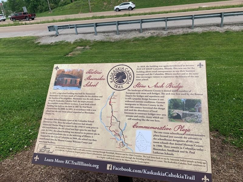
Historic Shoemaker School
In 1851, a leg school building was built by Hammond Shoemaker on his form south of Columbia for his children and the families of his neighbors. Shoemaker was the only doctor along the Kaskaskia Cahokia Trail, the major pioneer thoroughfare across Illinois territory A new brick school building was built on the farm in 1867 by Fred Koch Construction for $800. In 1891, in accordance with a new school law, the one room school organized as Shoemaker District# 4
Shoemaker School became a part of the Columbia School District in 1950. Since the school's directors had already contracted Marian Maag to teach for the 1950-51 term prior to this consolidation, the old school was kept open for one final year. In 1992, the school building was moved to its present site in order to avoid demolition due to the widening of Illinois 3 Acquired by the City of Columbia in 2009, the school was then transformed into the Monroe County Welcome Center and associated facilities.
In 2018, the building was again transformed to become Pop-Up Shop Columbia, Illinois. This new use for the building allows retail entrepreneurs
this page online
Stone Arch Bridge
The landscape of Monroe County is dotted with a number of European-style stone arch bridges. The arch was first used by the Roman Empire for bridges and aqueducts and is still a popular design because it can withstand extreme conditions. German immigrants to Monroe County in the mid 18th century borrowed this design and used the abundance of local limestone to construct bridges over area streams and creeks, many which are still standing like the one here.
The landscape of Monroe County is dotted with a number of European-style stone arch bridges. The arch was first used by the Roman Empire for bridges and aqueducts and is still a popular design because it can withstand extreme conditions. German immigrants to Monroe County in the mid 18th century borrowed this design and used the abundance of local limestone to construct bridges over area streams and creeks, many which are still standing like the one here.
Commemorative Plaza
The one room schoolhouse

Photographed by Thomas Smith, May 15, 2022
2. Historic Shoemaker School / Stone Arch Bridge / Commemorative Plaza Marker
Erected by Kaskaska-Cahokia Trail.
Topics. This historical marker is listed in these topic lists: Bridges & Viaducts • Education • Parks & Recreational Areas. A significant historical year for this entry is 1851.
Location. 38° 26.003′ N, 90° 11.337′ W. Marker is in Columbia, Illinois, in Monroe County. It is at the intersection of Illinois Route 3 and Gall Road, on the right when traveling south on Illinois Route 3. Touch for map. Marker is at or near this postal address: 32 Gall Rd, Columbia IL 62236, United States of America. Touch for directions.

Regionally, this marker is in Greater St. Louis. It is also in the American Midwest, in the Lewis & Clark Corridor, in the Corn Belt, and in the Great River Road Region. Globally, it is in North America, the Western Hemisphere, the Western World, and the Anglosphere. Historically, it finds itself in what was once the territory of the Mississippian Culture and also the Northwest Territory.
Other nearby markers. At least 8 other markers are within walking distance of this marker: Whiteside Station (about 700 feet away, measured in a direct line); Historic Shoemaker School (approx. 0.2 miles away); Veterans Memorial (approx. ¼ mile away); Columbia/Waterloo Road Whistle Post (approx. 0.3 miles away); Corporation Line Sign (approx. 0.4 miles away); South Meter Whistle Stop (approx. 0.4 miles away); Schmidt Beer Cave (approx. 0.4 miles away); Kaskaskia-Cahokia Trail (approx. half a mile away). Touch for a list and map of all markers in Columbia.
Credits. This page was last revised on September 1, 2022. It was originally submitted on August 26, 2022, by Thomas Smith of Waterloo, Ill. This page has been viewed 573 times since then and 46 times this year. Photos: 1, 2. submitted on August 26, 2022, by Thomas Smith of Waterloo, Ill. • Devry Becker Jones was the editor who published this page.
