Coltons Point in St. Mary's County, Maryland — The American Northeast (Mid-Atlantic)
Maryland Began Here
The Colonists Arrive
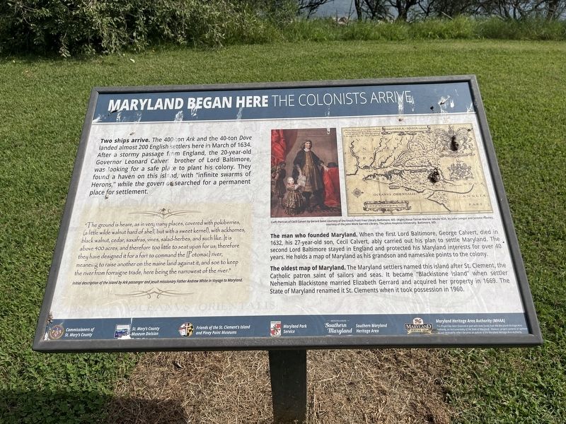
Two ships arrive. The 400-ton Ark and the 40-ton Dove landed almost 200 English settlers here in March of 1634. After a stormy passage from England, the 20-year-old Governor Leonard Calvert brother of Lord Baltimore, was looking for a safe place to plant his colony. They found a haven on this island, with "infinite swarms of Herons," while the governor searched for permanent place for settlement.
"The ground is heare, as in very many places, covered with pokiberries, (a little wilde walnut hard of shell, but with a sweet kernel), with ackhornes, black walnut, cedar, saxafras, vines, salad-herbes, and such like. It is above 400 acres, and therefore too little to seat upon for us; therefore they have designed it for a fort to command the [Potomac] river, meaneing to raise another on the maine land against it, and soe to keep the river from forraigne trade, here being the narrowest of the river."
Initial description of the island by Ark passenger and Jesuit missionary Father Andrew White in Voyage to Maryland
The man who founded Maryland. When the first Lord Baltimore, George Calvert, died in 1632, his 27-year-old son, Cecil Calvert, ably carried out his plan to settle Maryland. The second Lord Baltimore stayed in England and protected his Maryland interests for over 40 years. He holds a map of Maryland as his grandson and namesake points to the colony.
The oldest map of Maryland. The Maryland settlers named this island after St. Clement, the Catholic patron saint of sailors and seas. It became "Blackistone Island" when settler Nehemiah Blackistone married Elizabeth Gerrard and acquired her property in 1669. The State of Maryland renamed it St. Clements when it took possession in 1960.
Erected by Commissioners of St. Mary's County; St. Mary's County Museum Division; Friends of the St. Clement's Island and Piney Point Museum; Children of the American Colonists; Destination Southern Maryland; Southern Maryland Heritage Area, Maryland Heritage Area Authority.
Topics. This historical marker is listed in these topic lists: Animals • Colonial Era • Settlements & Settlers • Waterways & Vessels. A significant historical month for this entry is March 1634.
Location. 38° 12.771′ N, 76° 44.694′ W. Marker is in Coltons Point, Maryland, in St. Mary's County. The marker stands on St. Clement's Island which has no paved roads. Touch for map. Marker is in this post office area: Coltons Point MD 20626, United States of America. Touch for directions.
Other nearby markers. At least 8 other markers are within walking distance of this marker. This Stand of Trees (within shouting distance of this marker); St. Clement's Island State Park (about 700
Related marker. Click here for another marker that is related to this marker. This marker has replaced the linked marker.
Credits. This page was last revised on August 26, 2022. It was originally submitted on August 26, 2022, by Devry Becker Jones of Washington, District of Columbia. This page has been viewed 261 times since then and 43 times this year. Photos: 1, 2. submitted on August 26, 2022, by Devry Becker Jones of Washington, District of Columbia.

