Resaca in Gordon County, Georgia — The American South (South Atlantic)
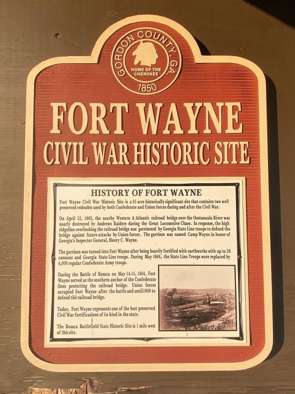
History of Fort Wayne
Fort Wayne
— Civil War Historic Site —
Fort Wayne Civil War Historic Site is a 65 acre historically significant site that contains two well preserved redoubts used by both Confederate and Union forces during and after the Civil War.
On April 12, 1862, the nearby Western & Atlantic railroad bridge over the Oostanaula River was nearly destroyed by Andrews Raiders during the Great Locomotive Chase. In response, the high ridgeline overlooking the railroad bridge was garrisoned by Georgia State Line troops to defend the bridge against future attacks by Union forces. The garrison was named Camp Wayne in honor of Georgia's Inspector General, Henry C. Wayne.
The garrison was turned into Fort Wayne after being heavily fortified with earthworks with up to 28 cannons and Georgia State Line troops. During May 1864, the State Line Troops were replaced by 4,000 regular Confederate Army troops.
During the Battle of Resaca on May 14-15, 1864, Fort Wayne served as the southern anchor of the Confederate lines protecting the railroad bridge. Union forces occupied Fort Wayne after the battle and until 1868 to defend the railroad bridge.
Today, Fort Wayne represents one of the best preserved Civil War fortifications of its kind in the state.
The Resaca Battlefield State Historic Site is 1 mile west of this site.
Topics. This historical marker is listed in these topic lists: Bridges & Viaducts • Forts and Castles • Railroads & Streetcars • War, US Civil. A significant historical date for this entry is May 14, 1864.
Location. 34° 34.957′ N, 84° 56.279′ W. Marker is in Resaca, Georgia, in Gordon County. Marker can be reached from Taylor Ridge Road east of Nicklesville Road NE (Georgia Route 136), on the right when traveling east. Located in Fort Wayne County Park. Touch for map. Marker is at or near this postal address: 164 Taylor Ridge Rd, Resaca GA 30735, United States of America. Touch for directions.
Other nearby markers. At least 8 other markers are within walking distance of this marker. Henry C. Wayne (here, next to this marker); 28th Ga. Co. G, Freeman's Guard (within shouting distance of this marker); Battle of Resaca (approx. 0.3 miles away); Oostanaula River Bridges (approx. ¾ mile away); Dancers in the Red Clay Minuet (approx. 0.9 miles away); South Toward Atlanta (approx. 0.9 miles away); Logan's XV Corps to the South (approx. 0.9 miles away); Resaca — A Defensible Position (approx. 0.9 miles away). Touch for a list and map of all markers in Resaca.
Credits. This page was last revised on September 19, 2022. It was originally submitted on September 17, 2022, by Darren Jefferson Clay of Duluth, Georgia. This page has been viewed 158 times since then and 47 times this year. Photos: 1, 2. submitted on September 18, 2022, by Darren Jefferson Clay of Duluth, Georgia. • Bernard Fisher was the editor who published this page.

