Near Sharpsburg in Washington County, Maryland — The American Northeast (Mid-Atlantic)
We Showered the Lead Across that Creek
Lt. George W. Whitman, 51st New York Infantry
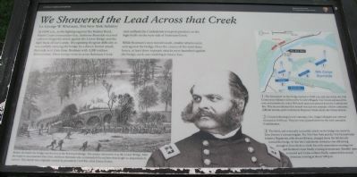
At 10:00 a.m., as the fighting raged as the Sunken Road, Ninth Corps commander Gen. Ambrose Burnside received orders to begin his attack against the Lower Bridge and the right flank of Lee's army. Recognizing the great difficulty in successfully carrying the bridge by a direct, frontal attack, Burnside sent Gen. Isaac Rodman with 3,200 soldiers downstream. These troops were to cross Antietam Creek and outflank the Confederate troops in position on the high bluffs on the west side of Antietam Creek.
While Rodman's men moved south, smaller attacks were sent against the bridge. Over the course of the next three hours, at least three separate attacks were launched against the bridge, each one resulting in heavy loss.
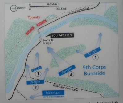
(1) The first attack on the bridge started at 10:00 a.m. and was led by the 11th Connecticut Infantry followed by Crook's Brigade. Col. Crook advanced his men and mistakenly ended 300 yards upstream pinned down by Confederate fire. This uncoordinated first assault was just one example of how confusion, difficult terrain, and Confederate firepower broke down the Union attacks.
(2) Closely following Crook's attempt, Gen. Nagle's Brigade was ordered forward at 11:00 a.m. They too were pinned down by the well concealed Confederates.
(3) The third, and eventually successful, attack on the bridge was made by Gen. Ferrero's veteran brigade. The 51st New York and the 51st Pennsylvania Infantry Regiments, with about 650 men, charged down the hill directly toward the bridge. At first the Confederate resistance was still strong enough to force them to a halt, but with ammunition running low and Rodman's men finally crossing downstream, Toombs' men retreated and Union soldiers finally captured this crucial Antietam crossing at about 1:00 p.m.
Erected 2009 by Antietam National Battlefield - National Park Service - U.S. Department of the Interior.
Topics. This historical marker is listed in these topic lists: War, US Civil • Waterways & Vessels.
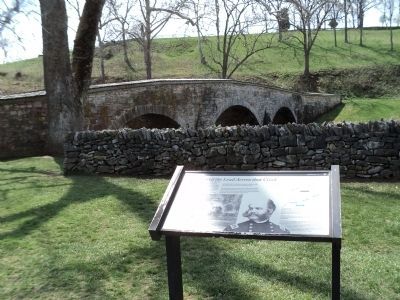
Location. 39° 27.043′ N, 77° 43.896′ W. Marker is near Sharpsburg, Maryland, in Washington County. Marker can be reached from Old Burnside Bridge Road, on the left when traveling east. Located to the east of stop 9 (Burnside Bridge) of the driving tour of Antietam Battlefield, along the walking trail east of the bridge. Touch for map. Marker is in this post office area: Sharpsburg MD 21782, United States of America. Touch for directions.
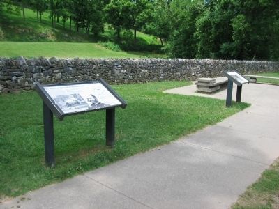
Other nearby markers. At least 8 other markers are within walking distance of this marker. "Will You Give Us Our Whiskey?" (here, next to this marker); 2nd Maryland Infantry (here, next to this marker); "Why Burnside's Bridge?"
(here, next to this marker); Bridge of Destiny (here, next to this marker); 35th Massachusetts Volunteer Infantry (here, next to this marker); 21st Massachusetts Volunteer Infantry (a few steps from this marker); 51st Pennsylvania Volunteer Infantry (a few steps from this marker); Witness to History (within shouting distance of this marker). Touch for a list and map of all markers in Sharpsburg.
More about this marker. On the lower left is a newspaper drawing depicting the capture of the bridge. Before the battle the bridge was known as the Rohrbach Bridge. The armies referred to it as the Lower Bridge. After the battle it was renamed after Gen. Ambrose Burnside who commanded the soldiers that fought so desperately to cross it. This sketch was originally created by prominent Civil War artist Edwin Forbes.
In the center is a portrait of Gen. Burnside. On the right is a map depiction the action in this sector of the battlefield.
Related marker. Click here for another marker that is related to this marker. This marker replaced an older one at this location titled "Will You Give Us Our Whiskey?"
Also see . . .
Antietam Battlefield. National Park Service site. (Submitted on July 11, 2009, by Craig Swain of Leesburg, Virginia.)
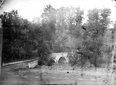
Photographed By Alexander Gardner
5. Burnside Bridge - Union view of the Approach
This photograph taken two days after the battle, is from a similar angle to the modern photo above. Note the "witness tree" which stands on the near end of the bridge in this photograph. It still stands and has grown over the years.
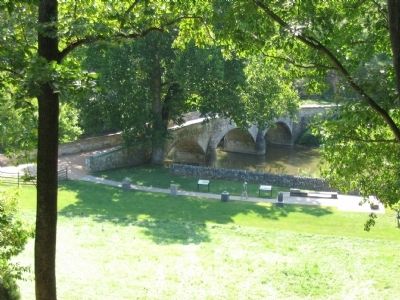
Photographed By Craig Swain
6. Similar View of the Bridge Today
The two regiments formed behind Nagle's Brigade, then rushed forward onto the bridge, side by side. Note the small tree in Forbes' drawing which stood next to the wall on the near side landing of the bridge. That tree has grown substantially, and survives as a witness to the battle, seen in the break of the stone wall at the bridge abutment.
Credits. This page was last revised on April 2, 2022. It was originally submitted on July 11, 2009, by Craig Swain of Leesburg, Virginia. This page has been viewed 1,245 times since then and 19 times this year. Photos: 1. submitted on July 11, 2009, by Craig Swain of Leesburg, Virginia. 2. submitted on April 16, 2011, by Bill Coughlin of Woodland Park, New Jersey. 3, 4. submitted on July 11, 2009, by Craig Swain of Leesburg, Virginia. 5. submitted on April 28, 2008, by Dennis M. Sheron of Hudson, Indiana. 6. submitted on March 22, 2008, by Craig Swain of Leesburg, Virginia.
