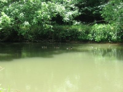
Near Sharpsburg in Washington County, Maryland — The American Northeast (Mid-Atlantic)
U.S. Geological Survey Streamflow-Gaging Station
Antietam Creek near Sharpsburg, Maryland
Inscription.
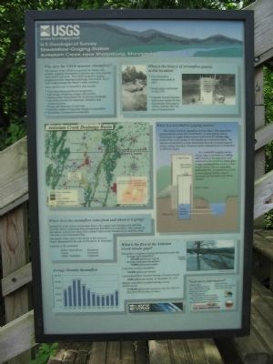
Why does the USGS measure Streamflow?
The mission of the USGS is to provide the Nation with reliable, impartial information to describe and understand the Earth and its resources. The USGS streamflow-gaging program provides important hydrologic information that is used to help manage the Nation's water resources.
Some specific uses of streamflow data include:
• Flood forcasting and flood management
• Safe design of highway bridges and culverts
• Setting permit requirements for wastewater discharges
• Allocation of water for for municipal, industrial, and commercial uses
• Design and operation of reservoirs
• Scientific studies of long-term changes in streamflow
• Scheduling of hydropower production
What is the history of streamflow gaging at this location?
• First streamflow measurement made in 1897.
• Stream gage constructed in July 1933
• Concrete control structure built across stream 80 feet downstream from gage in 1934 to stabilize flow for ease of measurement.
What is a streamflow-gaging station?
The USGS monitors streamflow at more than 7,200 streamflow gaging stations across the United States. At each gaging station, instruments in a gage house measure and record the stream stage (level of the water surface of the stream) on a continuous basis. The amount of streamflow is later determined from the recorded stage by using a rating chart that is based on direct measurements of streamflow at different stages.
At a streamflow-gaging station, stream stage is recorded in a stilling well located in the gage house and connected to the stream by intake pipes. A stage-sensing device, such as a float-weight system, drives a recording instrument that is regulated by a clock. At most gaging stations, stage is measured and recorded every fifteen minutes.
Where does the streamflow come from and where is it going?
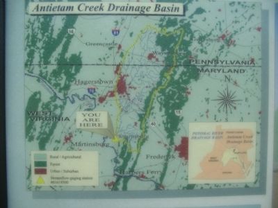
Streamflow at this station accumulates from a 281-square-mile drainage area upstream from the station, originating from precipitation that falls in the watershed. After passing by this station, waster in the stream flows about 4 miles to the Potomac River and then about 180 miles to the Chesapeake Bay.
The quality of the water in the stream at this station is largely determined by the uses of the land in its watershed.
Land use in the watershed:
Rural/Agricultural: 66 percent
Forest: 24 percent
Urban/Suburban: 10 percent
What is the flow at the Antietam Creek stream gage?
Streamflow is highest in spring and lowest in early fall:
Average April streamflow: 209,000 gallons per minute
Average September streamflow: 73,000 gallons per minute
Long-term average streamflow: 126,000 gallons per minute
Lowest streamflow recorded (during a drought period): 4,200 gallons per minute on November 22, 1957
Highest streamflow recorded (during a severe thunderstorm): 5,700,000 gallons per minute on July 20, 1956 (8.7 feet above flood stage of 8 feet)
Erected by U.S. Geological Survey and Maryland State Highway Administration.
Topics. This historical marker is listed in these topic lists: Natural Features • Waterways & Vessels. A significant historical month for this entry is July 1933.
Location. 39° 26.999′ N, 77° 43.838′ W. Marker is near Sharpsburg, Maryland, in Washington County. Marker can be reached from Old Burnside Bridge Road, on the right when traveling north. Located about 100 yards south of the Burnside Bridge in Antietam National Battlefield. Touch for map. Marker is in this post office area: Sharpsburg MD 21782, United States of America. Touch for directions.
Other nearby markers. At least 8 other markers are within walking distance of this marker. Ninth Army Corps (within shouting distance of this marker); As the Georgians Saw It (within shouting distance of this marker); a different marker also named Ninth Army Corps (about 300 feet away, measured in a direct line); Sturgis's Division, Ninth Army Corps (about 300 feet away); Fifty-First New York Infantry (about 300 feet away); a different marker also named Ninth Army Corps (about 300 feet away); a different marker also named Ninth Army Corps (about 300 feet away); Eleventh Connecticut Infantry (about 300 feet away). Touch for a list and map of all markers in Sharpsburg.
More about this marker. At the top of the marker are photos showing the construction of the gaging station. In the middle is a map of the Antietam Creek Drainage Basin. Beside it is an illustration complementing the text explaining the workings of the station. At the bottom is a photo of the Burnside Bridge during a 1996 flood. A bar chart to the lower left shows average monthly streamflow.
Also see . . . Streamflow Statistics for the Station. USGS site showing statistics for the last three years. A link on the site offers real time data. (Submitted on July 12, 2009, by Craig Swain of Leesburg, Virginia.)
Credits. This page was last revised on December 7, 2017. It was originally submitted on July 12, 2009, by Craig Swain of Leesburg, Virginia. This page has been viewed 1,455 times since then and 44 times this year. Photos: 1, 2, 3, 4, 5. submitted on July 12, 2009, by Craig Swain of Leesburg, Virginia.
