Bloomfield in Stoddard County, Missouri — The American Midwest (Upper Plains)
General Davidson's Cavalry

Photographed by Craig Swain, September 28, 2022
1. General Davidson's Cavalry Marker (front)
This large force moved from Missouri's Arcadia Valley to assume control of Crowley's Ridge in southeast Missouri and northeast Arkansas. This ridge had the only all-weather road through the huge swamps and wetlands of the area. Bloomfield was the largest and most prominent Missouri town on the ridge.
When Davidson's command reached Bloomfield, they discovered the town of approximately 1,100 people to be nearly deserted. A Union soldier wrote in his diary, "Bloomfield was once a very pretty town, but since the war has been totally demolished." [Actually the academy, the courthouse, a few businesses and homes
this page online
(Back):
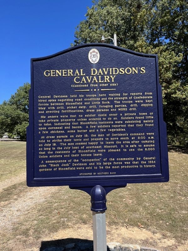
General Davidson held his troops here waiting for reports from hired spies regarding road conditions and the strength of Confederate forces between Bloomfield and Little Rock. The troops were kept busy with drill, picket duty, drill, foraging parties, drill, digging and erecting fortifications, dress parades and MORE drill.
His orders were that no soldier could enter a private home or take private property unless ordered to do so. Soldiers found little to take, indicating that Bloomfield residents were subsisting mainly on cornmeal and bacon. A few soldiers reported that they found a few chickens, some butter and a few vegetables.
At dress parade on July 18, the men of Davidson's command were told to strike their tents and prepare to move south at 8:00 a.m. on July 19. The men seemed happy to leave the area after camping so long in the July heat of southeast Missouri. It is safe to assume that the residents of Bloomfield were
Photographed by Craig Swain, September 28, 2022
2. General Davidson's Cavalry Marker (back)
A consequence of the "occupation" of the community by General John "Black Jack" Davidson and his large force was that the 1864 gardens of Bloomfield were said to be the most productive in history.
Sponsored by Southern Bank
Topics. This historical marker is listed in this topic list: War, US Civil. A significant historical month for this entry is June 1863.
Location. 36° 52.67′ N, 89° 55.902′ W. Marker is in Bloomfield, Missouri, in Stoddard County. It can be reached from the intersection of Park Avenue and McLain Lane, on the right when traveling west. Located in Bloomfield Park. Touch for map. Marker is in this post office area: Bloomfield MO 63825, United States of America. Touch for directions.

Regionally, this marker is in Southeast Missouri and specifically in the Missouri Bootheel. It is also in the American Mississippi Delta, in the Ozarks, in the Lewis & Clark Corridor, and in the Corn Belt. Globally, it is in North America, the Western Hemisphere, the Western World, and the Anglosphere. Historically, it finds itself in what was once the territory of the

Photographed by Craig Swain, September 28, 2022
3. General Davidson's Cavalry Marker
Other nearby markers. At least 8 other markers are within walking distance of this marker: Stoddard County (about 500 feet away, measured in a direct line); Mutiny in Bloomfield (approx. 0.4 miles away); The First Stars and Stripes (approx. half a mile away); Major Amos Stoddard (approx. half a mile away); The Civil War in Bloomfield (approx. half a mile away); The Execution of Asa V. Ladd (approx. half a mile away); Stoddard Countians Aboard the C.S. Arkansas (approx. half a mile away); The Fatal Tree (approx. half a mile away). Touch for a list and map of all markers in Bloomfield.

courtesy of Wikipedia Commons
4. General John W. Davidson
After the Little Rock campaign, Davidson went on to lead a raid through Mississippi and hold various administrative and garrison posts for the remainder of the war. After the war, he led the 10th U.S. Cavalry, a colored regiment. During that time, he received the nickname "Black Jack," as cited on the marker.
Credits. This page was last revised on October 11, 2022. It was originally submitted on October 11, 2022, by Craig Swain of Leesburg, Virginia. This page has been viewed 383 times since then and 56 times this year. Photos: 1, 2, 3, 4. submitted on October 11, 2022, by Craig Swain of Leesburg, Virginia.
