Old Westport in Kansas City in Jackson County, Missouri — The American Midwest (Upper Plains)
Action Before Westport
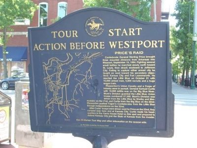
Confederate General Sterling Price brought three mounted divisions from Arkansas into Missouri, September 19, 1864. Fighting several small battles he marched slowly north toward St. Louis, then struck westward to Jefferson City. Failing to capture either armed city he fought on west toward his secondary objectives: Kansas City and Fort Leavenworth. He reached the Little Blue on October 21 with 15,000 armed men, 5,000 recruits and a huge wagon train.
Pleasonton's Union Cavalry and a Corps of Infantry were in pursuit. General Samuel Curtis with 10,000 militia was on the Big Blue River. Blunt's Division guarded the Little Blue. Union troops numbered 27,500. Blunt's Division was driven from the Little Blue by Shelby and Marmaduke on the 21st, and Curtis from the Big Blue on the 22nd. Pleasonton pushed Fagan's Confederates from the Little Blue through Independence on the 22nd.
After Curtis' troops were driven west by Price on the 22nd, they camped near here and at Kansas City. Curtis made his headquarters in the Harris Hotel on this spot and prepared to defend Kansas City and the State of Kansas from the invader.
Next Stop: See 23-marker Tour Map and other information on the reverse side.
This marker donated by The Westport Bank.
(Back of Marker):
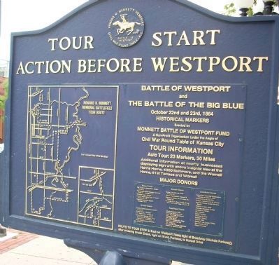
and
The Battle of the Big Blue
October 22nd and 23rd, 1864
Historical Markers
Erected by
Monnet Battle of Westport Fund
A Non-Profit Organization Under the Aegis of
Civil War Round Table of Kansas City
Tour Information
Auto Tour: 23 Markers, 30 Miles
Additional Information at nearby businesses
displaying sign with above insignia; also at the
Harris Home, 4000 Baltimore, and the Wornall
Home, 61st Terrace and Wornall.
Major Donors:
Family of Alexander J. Barket, Marker 17
Johnson County National Bank & Trust Co, markers 6 & 8
Westport Bank, Marker 1
Padgett Instruments & Earl C. Padgett, markers 15 & 21
Westport Historical Society, markers 4 & 11
Sponsor Donors:
Jackson County Historical Society, marker 5
Martha Fowk, marker 7
J.C. Nichols Co., marker 12
Kansas City Chapter United Daughters (& Children) of the Confederacy, marker 13
United Telecom, Inc. marker 14
Kansas City Star and Times, Marker 17a
Amoco Oil Co., marker 19
Historical Society of New Santa Fe, marker 22
In Honor of Dr. Bert Maybee, by the Civil War Round Table, marker 23
Contributing Donors:
Hardin Stocton Corp.
American Cynamid Corp
Civil War Times Illustrated
Nichols Industries
Mr. Jerry Krause
Stratford Graham Eng. Corp
Pepsi-Cola Bottlers, Inc.
B.F. Ascher Co.
Edward John Wimmer, architect
Stanley L. Goldman, M.D.
Kansas City Posse the Westerners in memory of Robert L. Buck
Native Sons of Kansas City
Faculty, Metropolitan JR. College
Shawnee County Kansas Historical Society
William A. Goff
ROUTE TO TOUR STOP 2: East on Westport Road; right at Broadway (Nichols Parkway) after crossing Brush Creek; right on Ward Parkway, to Sunset Drive.
Erected by Monnett Battle of Westport Fund. (Marker Number 1.)
Topics and series. This historical marker is listed in this topic list: War, US Civil. In addition, it is included in the Missouri – Battle of Westport, and the United Daughters of the Confederacy series lists. A significant historical date for this entry is September 19, 1812.
Location. 39° 3.183′ N, 94° 35.492′ W. Marker is in Kansas City, Missouri, in Jackson County. It is in Old Westport. Marker is at the intersection of Pennsylvania Avenue and Westport Road, on the right when traveling north on Pennsylvania Avenue. Touch for map. Marker is in this post office area: Kansas City MO 64111, United States of America. Touch for directions.
Other nearby markers. At least 8 other markers are within walking distance of this marker. Original Site of Harris House (here, next to this marker); The Albert G. Boone Store
(a few steps from this marker); The French and the Santa Fe Trail (within shouting distance of this marker); McCoy's Trading Post (within shouting distance of this marker); Three Trails West (about 300 feet away, measured in a direct line); Alexander Majors (about 300 feet away); John Calvin McCoy (about 300 feet away); James Bridger (about 300 feet away). Touch for a list and map of all markers in Kansas City.
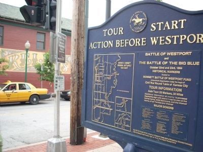
More about this marker. There are markers on all four corners of this intersection. This metal marker is located on the northeast corner along with the pink granite marker for the site of the Harris House.
Also see . . . Battle of Westport. Stop 1 of the Battle of Westport Tour (Submitted on July 16, 2009, by Thomas Onions of Olathe, Kansas.)
Credits. This page was last revised on February 10, 2023. It was originally submitted on July 16, 2009, by Thomas Onions of Olathe, Kansas. This page has been viewed 1,774 times since then and 38 times this year. Photos: 1. submitted on July 18, 2009, by Thomas Onions of Olathe, Kansas. 2, 3. submitted on July 16, 2009, by Thomas Onions of Olathe, Kansas. • Craig Swain was the editor who published this page.


