North Little Rock in Pulaski County, Arkansas — The American South (West South Central)
The Arkansas River Trail Story
Arkansas River Trail
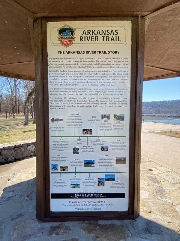
In 2006 the Big Dam Bridge was completed across the Murray Lock and Dam, the longest pedestrian/bicycle bridge in the world built exclusively for recreational use. The bridge linked Little Rock and North Little Rock portions of the trail, allowing cyclists and walkers to make a 15-mile loop between downtowns and the Murray Lock and Dam. The trail is complete along the north shore from this location to downtown. It also extends through Little Rock's Rebsaman Park, and work continues to close the final gaps on the south side.i
Along the trail you can access a Presidential Library, a nature center, six museums, and numerous restaurants and shops, including a bike rental. Just as important, you can use the trail to take a breather from the city and enjoy trees, birds, and wildlife in at least ten separate parks.
There is also an 88.5 mile Grand Loop which extends north to Conway in Faulkner County, and back along the south side through Perry County. The Southeast Trail extends past the Clinton Airport, through the Little Rock Port and David Terry Dam. The Southwest Trail is being planned, and will extend from the Arkansas River Trail through Benton all the way to Hot Springs, Arkansas.
Timeline
1913-City of Little Rock plans called for a series of parks along the banks of the Arkansas River.
1971-Metroplan, Little Rock, North Little Rock and AIA developed designs for park space along the Arkansas River in Pulaski County. Over the ensuing decades this became Riverfront Park and a chain of other parks.
1980s-1990s-The concept of the Arkansas River Trail as a means to tie those parks together was born of the River Project, a county-wide civic endeavor that resulted in expanding the Little Rock Convention Center and building Alltel, now Verizon Arena on the north shore (1999).
1987-Riverfest Amphitheater was built.
Early 1990s-Riverfront Park in Little Rock was completed. The park provides 33 acres of urban parkland for outdoor events.
1996-North Little Rock'sNorth Shore Riverwalk Park was completed.
2002-The trail in North Little Rock from the Rock Quarry to the Big Dam Bridge was completed.
2003-The Medical Mile was completed, made possible by a group of physicians with the goal of increasing awareness and preventing obesity and heart disease.
2006-The Big Dam Bridge opened. It is the world's longest pedestrian and bicycle bridge built specifically for that use.
2006-The Big Dam Bridge 100 inaugural race took place with 1200 participants. The race now brings 3000 riders from 30 states and 5 countries, and contributes $1 million to the local economy.
2008-The 1899 Choctaw and Memphis/Union Pacific Railroad bridge was converted to the Junction Bridge as a pedestrian/bicycle bridge.
2009-Vogel-Schwartz Sculpture Garden was completed. The garden features over 75 public art sculptures valued at over $2 million.
2001-The 1899 former Rock Island Railroad Bridge converted to the bicycle/pedestrian Clinton Presidential Park Bridge.
2001-The Two Rivers Park Bridge was completed.
2012-A Memorandum of Understanding was signed by eleven entities, signaling multi-jurisdiction support for the Arkansas River Trail.
2014-The Southwest Trail MOU was signed by eleven jurisdictions to work together to develop bicycle/pedestrian facilities between Little Rock and Hot Springs. Much of the route is planned to follow an abandoned railroad right-of-way.
2017-The new Broadway Bridge will have a protected bicycle/pedestrian lane and will link directly to the Arkansas River Trail.
Topics. This historical marker is listed in these topic lists: Parks & Recreational Areas • Waterways & Vessels.
Location. 34° 47.705′ N, 92° 21.186′ W. Marker is in North Little Rock, Arkansas, in Pulaski County. Marker is on Cook's Landing Road, on the left when traveling east. Touch for map. Marker is at or near this postal address: 4100 Cook's Landing Rd, North Little Rock AR 72118, United States of America. Touch for directions.
Other nearby markers. At least 8 other markers are within 3 miles of this marker, measured as the crow flies. Four Bridges (here, next to this marker); Looking Down the Arkansas River to the East (approx. 0.4 miles away); Looking Down the Arkansas River to the West (approx. 0.4 miles away); McClellan-Kerr Arkansas River Navigation System (approx. 0.4 miles away); The Story of the Big Dam Bridge Monoliths (approx. half a mile away); The Farmers Home Cemetery (approx. half a mile away); The Heights A History (approx. 1.9 miles away); Block Realty-Baker House (approx. 2.4 miles away). Touch for a list and map of all markers in North Little Rock.
Credits. This page was last revised on November 1, 2022. It was originally submitted on October 29, 2022, by Darren Jefferson Clay of Duluth, Georgia. This page has been viewed 89 times since then and 25 times this year. Photos: 1, 2. submitted on October 29, 2022, by Darren Jefferson Clay of Duluth, Georgia. • Mark Hilton was the editor who published this page.

