Lower Township near West Cape May in Cape May County, New Jersey — The American Northeast (Mid-Atlantic)
Slaughter in Cape May
Cape May Point State Park
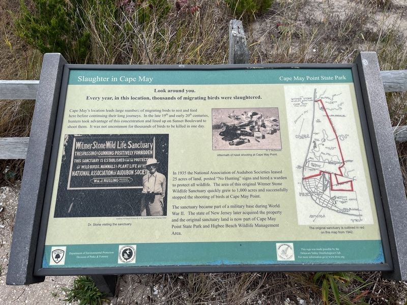
Every year, in this location, thousands of migrating birds were slaughtered.
Cape May's location leads large numbers of migrating birds to rest and feed here before continuing their long journeys. In the late 19th and early 20th centuries, hunters took advantage of this concentration and lined up on Sunset Boulevard to shoot them. It was not uncommon for thousands of birds to be killed in one day.
In 1935 the National Association of Audubon Societies leased 25 acres of land, posted "No Hunting" signs and hired a warden to protect all wildlife. The area of this original Witner Stone Wildlife Sanctuary quickly grew to 1,000 acres and successfully stopped the shooting of birds at Cape May Point.
The sanctuary became part of a military base during World War II. The state of New Jersey later acquired the property and the original sanctuary land is now part of Cape May Point State Park and Higbee Beach Wildlife Management Area.
Erected by Department of Environmental Protection, Division of Parks & Forestry; Delaware Valley Ornithological Club.
Topics. This historical marker is listed in these topic lists: Animals • Environment • Forts and Castles • Parks & Recreational Areas • War, World II. A significant historical year for this entry is 1935.
Location. 38° 56.65′ N, 74° 58.162′ W. Marker is near West Cape May, New Jersey, in Cape May County. It is in Lower Township. Marker is on Sunset Boulevard (County Road 606) 0.4 miles west of Cape Avenue, on the left when traveling west. Touch for map. Marker is at or near this postal address: 507 Sunset Blvd, Cape May NJ 08204, United States of America. Touch for directions.
Other nearby markers. At least 8 other markers are within walking distance of this marker. Dr. Witmer Stone: Noted Ornithologist, 1866 - 1939 (here, next to this marker); S.S. Atlantus (within shouting distance of this marker); Ens. Harry V. Groome, Jr. (within shouting distance of this marker); All Veterans Memorial (about 700 feet away, measured in a direct line); The abrupt end of Fort Miles (about 700 feet away); Landscape (about 700 feet away); The Top of the Fire Tower (about 700 feet away); History of Coastal Defenses (about 700 feet away).
Credits. This page was last revised on February 7, 2023. It was originally submitted on November 3, 2022, by Devry Becker Jones of Washington, District of Columbia. This page has been viewed 100 times since then and 12 times this year. Photos: 1, 2. submitted on November 3, 2022, by Devry Becker Jones of Washington, District of Columbia.

