Near Carter in Beckham County, Oklahoma — The American South (West South Central)
Highway
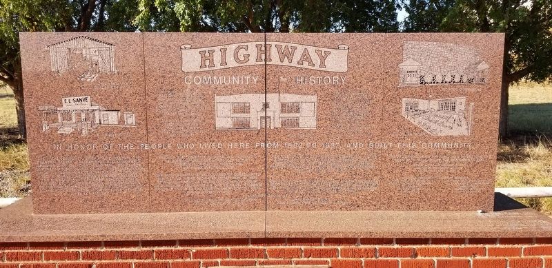
Community History
Life in the community, which at one time included 2 general stores, a barber shop, blacksmith shop, grain grinding mills, church and family residences, centered around Highway school. There was always an active ladies home demonstrations club and in 1931, a community builders club was organized for the betterment of homes, schools, roads, farming, etc, in the community. Demonstrations on contour farming, and terracing were held and high school boys were taught to survey terrace lines for farmers.
Through the committee on rural electrification, electricity was first introduced to the community on Dec. 24, 1939 by the Northfork Electric Co-Op.
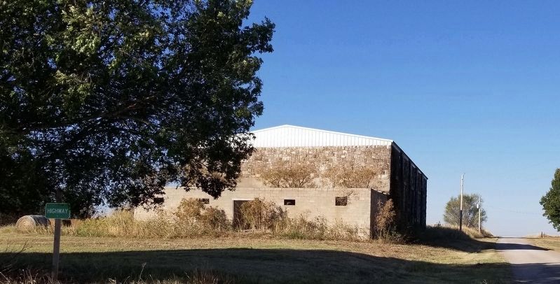
The brick building to be occupied by Consolidated District No. 3 was dedicated Friday, April 14, 1922. It was built next to the Dallas-Canadian-Denver (DCD) Highway, from which it got its name. Students brought honor to the name "Highway School" until it was closed in 1957.
Scholastic and citizenship achievement, 4-H Club and athletic activities offered a broad range of opportunity to learn responsibility and prepare for life's challenges. Family support and community spirit to excel was strong.
On July 3, 1971, the Highway School Alumni Association was formed and their first reunion was held on that date. Highway School Alumni, parents and neighbors have met annually since that time.
Highway Missionary Baptist Church
Taylor Church of Christ
Ural Baptist Church
Zion Chapel Free Methodist Church
Special gratitude to Phyllis Jones Henry who has
been Sec. Treas since the beginning in 1971.
Highway School Alumni Association
Oklahoma Historical Society
Dedicated July 4 1997
Historical Monument Committee Members
Joe Cain - Chairman
Phyllis J. Henry - Secretary
T.C. Henry
Jessie E. Henry
Ann Britton
Joe Britton - Vice Chairman
Glenna Evans - Treasurer
Jimmy Evans
Elwanda B. McGomas
Doyle Bloomer
Captions
Upper Left: John Hestand's Blacksmith Shop
Middle Left: E.L. Sanve Store
Center: High School
Center Left: June 16, 1921 there was an election at Taylor School for the consolidation of Taylor and Sadler Schools and parts of Ural and Poarch Schools. It carried by a vote of 108 for and 54 against. July 2, 1921 school bond election in the new consolidated district carried by a vote of 105 for and 34 against.
Center Right: July 15, 1921 the new Consolidated District had its first annual meeting. They
voted for an eight month term of school. This first year the name selected for the new district was Highway. Land for the memorial was given by the children of Aud Kennemer. Art work by Joe R. Waldrop.
Upper Right: School Gymnasium
Middle Right: The Jr. Sr. Room
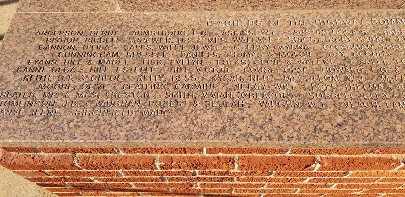
2nd Plaque on flat stone of marker
Anderson, Benny Armstrong, E.R. Askins, W.I. Austin, Nora B. Bishop, Birdell Brewer, Dr. & Mrs. Wallace Bright, Ruby Hagin Cannon, D'Lila Capps, Willie Jewel Cherry, Myrna Clearman, Thelma Cunningham, Russell Daniels, Thomas & Molcie Day, Blonda Evans, Bill & Mabel Fisk, Evelyn Folks, Cecil & Walene Fowler, Lois Hanni, Olga Hill, Estelle Hill, Victor House, Opal Howard, E.G. & Ethel Keith, O.T. & Chloe Kelly, Bess Kysar, Ned McCollom, W.J. Moore, Olive Peatling, Carmine Piergy, Will Poff, Thelma Slater, Mr. & Mrs, Preston Smith, Vivian (Creason) Sorrell, Ella Tomlinson, J.B. Vaughan, Robert & Beulah Vaughn, W.T. Veach, Lam ...anve, Ilene Birchheld, Maud Baber, Mrs. Earl Bashum, R.O. (1st Supt.) Belle, Erna Brown, Monte Bullington, Sy Byrom, Mary Edna Cox, Kenneth Crane, C.A. Cunningham, John Devault, Eddie Edwards, Rob Elkouri, Evelyn Gilchrist, Lois (Jones) Gilliland, J.R. & Sarena Johns, Chaude Jamison, Mr. Kane, Rosemary McFarland, Eloise McGee, Horace Montgomery, Claude Rice, Kirk Simpkins, S.L. & Edna A. Simpson, Mable Stead, Nona Lee Thomas, Grover Tomlinson, Mrs. Willie Vincent, Cora Weil, Herb Wilson, Alex Sr. & Visa
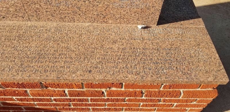
The school lunch program was started in 1936 by Supt. A.N. Wilson and Mrs. Lyda Jane Carruthers. The first menu of soup and crackers for 5 cents, evolved into an excellent hot lunch program. On June 26, 1938, Lydia J. Carruthers was awarded the certificate of merit by Governor E.W. Marland, for her leadership in promoting the health and welfare of the school children of Oklahoma through the school lunch program. Other area ladies that managed and worked in the lunchroom until the school closed in 1957 were; Esther Lee Bills, Mamie Cain, Ola Culberson, Alma Hill, Thelma Hyder, Mattie Lundy, Gladys Mooney, Lillie Ross, and Laverne Webb.
The heating system was a 1921 model steam boiler that did an excellent job of heating the school building. It was fired with coal until 1926 when the Oklahoma Natural Gas Co. made natural gas available. The sanitation facilities were outdoor privies. The only hand washing facility was the pump spout at the cistern where rain water was caught from the building roof for drinking water. The janitor pumped the drinking water
by hand, carried it down stairs through the basement, up another set of stairs into the auditorium and poured it into a wooden barrel, which had 4 brass drinking spigots attached to it. The wash water was then carried back outside. In the early 1950's, water was piped in and bathrooms and showers installed.
A.O. Cain was the first janitor-custodian. Others that worked through the years were: Walter Bowen, Alton Cain, Fred Cain, Loyd Cain, Pete Connors, Mr. Covington, Mr. Glover, Spot House, Jesse Johns, Earl Kennemer, Frank Lane, Arthur Ross, and Charley Webb.
Erected 1997 by Highway School Alumni Association and Oklahoma Historical Society.
Topics and series. This historical marker is listed in these topic lists: Agriculture • Education • Industry & Commerce • Settlements & Settlers. In addition, it is included in the Rural Electrification 💡 series list. A significant historical year for this entry is 1892.
Location. 35° 13.998′ N, 99° 25.054′ W. Marker is near Carter, Oklahoma, in Beckham County. Marker is at the intersection of County Highway 1230 and County Highway 2000, on the left when traveling west on County Highway 1230. The marker is located at the intersection. Touch for map. Marker is in this post office area: Carter OK 73627, United States of America. Touch for directions.
Other nearby markers. At least 8 other markers are within 13 miles of this marker, measured as the crow flies. National Route 66 Museum and Old Town Museum Complex, Elk City, Oklahoma (approx. 12.4 miles away); Commotion (approx. 12.4 miles away); Rock Bluff School (approx. 12.4 miles away); Gas Pump (approx. 12.4 miles away); Cruze Farm House History (approx. 12.4 miles away); The Anadarko Basin (approx. 12.4 miles away); First Wooden Home (approx. 12.4 miles away); 018 Cowtown (approx. 12.4 miles away).
Credits. This page was last revised on November 6, 2022. It was originally submitted on November 5, 2022, by James Hulse of Medina, Texas. This page has been viewed 299 times since then and 93 times this year. Photos: 1, 2, 3, 4, 5. submitted on November 6, 2022, by James Hulse of Medina, Texas.


