Spring Arbor in Jackson County, Michigan — The American Midwest (Great Lakes)
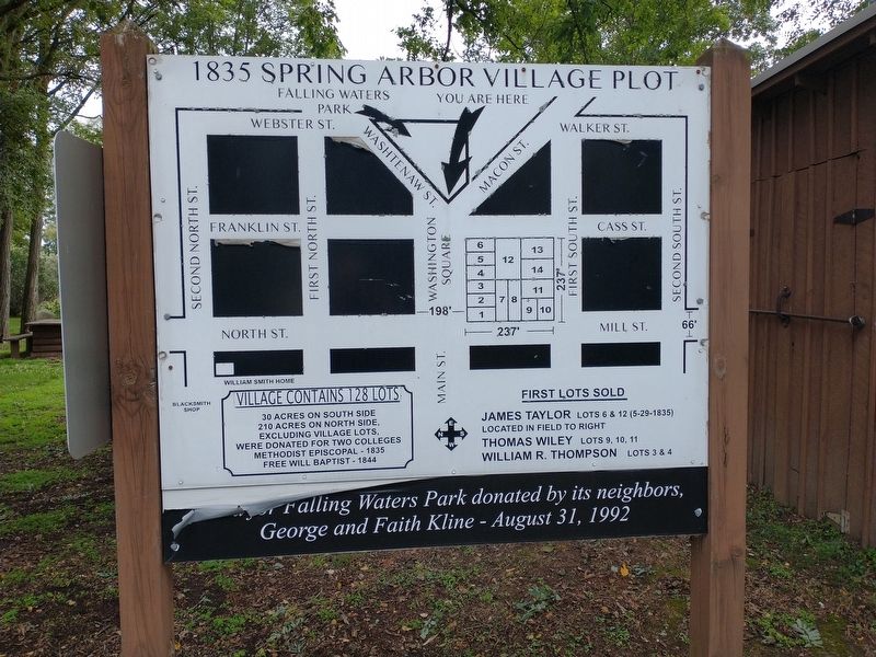
1835 Spring Arbor Village Plot
30 Acres On South Side
210 Acres On North Side.
Excluding Village Lots.
Were Donated For Two Colleges
Methodist Episcopal 1835
Free Will Baptist-1844
First Lots Sold
James Taylor Lots 6 & 12 (5-29-1835)
Located In Field To Right
Thomas Wiley Lots 9, 10, 11
William R. Thompson Lots 3 & 4
Land for Falling Waters Park donated by its neighbors, George and Faith Kline - August 31, 1992
Topics. This historical marker is listed in these topic lists: Parks & Recreational Areas • Settlements & Settlers. A significant historical date for this entry is August 31, 1992.
Location. 42° 11.352′ N, 84° 34.539′ W. Marker is in Spring Arbor, Michigan, in Jackson County. Marker is on Hammond Road west of Cross Road, on the right when traveling east. Touch for map. Marker is at or near this postal address: 8770 Hammond Rd, Spring Arbor MI 49283, United States of America. Touch for directions.
Other nearby markers. At least 8 other markers are within walking distance of this marker. Native Herb Garden (a few steps from this marker); Letter From Mrs Matilda of Albion... March, 1914 (within shouting distance of this marker); 70th Year of Pearl Harbor Day (within shouting distance of this marker); Methodist Episcopal College (within shouting distance of this marker); No They Are Not Here (within shouting distance of this marker); 1835 Spring Arbor Village (within shouting distance of this marker); Potowatomi Burial Site (about 300 feet away, measured in a direct line); Huron Potawatomi Village / Spring Arbor (about 300 feet away). Touch for a list and map of all markers in Spring Arbor.
Credits. This page was last revised on November 28, 2022. It was originally submitted on November 18, 2022, by Craig Doda of Napoleon, Ohio. This page has been viewed 98 times since then and 11 times this year. Photo 1. submitted on November 18, 2022, by Craig Doda of Napoleon, Ohio. • Devry Becker Jones was the editor who published this page.
Editor’s want-list for this marker. A wide shot of the marker in context • Can you help?
