West Seventh - Fort Road in Saint Paul in Ramsey County, Minnesota — The American Midwest (Upper Plains)
Industry at the River's Edge ⎯⎯⎯ West Seventh Street and Fort Road
Photographed by McGhiever, September 4, 2022
1. Industry at the River's Edge Marker
Inscription.
Industry at the River's Edge, also, West Seventh Street and Fort Road. . ,
... St. Paul, by the vigilance, energy, enterprise and united action of her leading citizens has succeeded in making herself the railroad center and headquarters of the northwestern region ... Railroads are now-a-days the most potent factors in the growth of a city. , Minneapolis Tribune, November 13, 1879.
, The river's edge west of downtown St. Paul has long supported many types of industry. The area around Randolph Street and Shepard Road was first a center for breweries, factories and railroad shops, followed by power generation and grain storage businesses. A nearby labor force was housed in the West End's densely-built neighborhoods. During the 1930s, the U.S. Army Corps of Engineers transformed the river with projects that deepened and widened the channel for navigation and flood control and also improved barge shipping.,
The Omaha Road. In 1881 the Chicago St. Paul Minneapolis and Omaha Railway (CStPM&O) built its West division Shops at Randolph and Drake streets. The brick roundhouse for locomotive repair was the centerpiece of the large complex and was flanked by machine, boiler, and other shops. This railroad company, known as the Omaha Road, was created in 1880 from several smaller railroads. Headquartered in St. Paul, the line carried farm products, lumber, and passengers across 1,700 miles of track in five states. In 1882 the Chicago and Northwestern (C&NW) purchased a controlling interest in the company. The independent Omaha Road was entirely purchased by the C&NW in 1972; in 1995 the C&NW merged into the Union Pacific Railroad., The shops were cleared in the 1950s for construction of Shepard Road. In 1954 Archer Daniels Midland (ADM) built its Elevator D complex on a portion of the site. The six-story concrete silos provide storage for two million bushels of grain, typically corn, soybeans, and wheat. Grain is loaded to barges as well as Union Pacific Railroad cars.,
Omaha Road Swing Bridge. The Omaha Road Swing Bridge Number 15 is the second railroad bridge to span the Mississippi below Randolph Avenue. The previous wood Howe-truss structure was built in 1869 and was one of the original 15 Mississippi River bridges. The CStPM&O and the Chicago, Milwaukee, and St. Paul (CM&StP) railways built the new structure in 1915. The 1,055-foot-long assymetrical design was needed because the 160-foot-wide river channel is not deep enough at this point to accommodate a full-sized bridge. A concrete counterweight keeps both ends of the bridge in balance over the center pier. The bridge is now used by the Canadian Pacific and the Union Pacific railroads., CStMP&O railroad cars approaching the Wabasha and High bridges, 1895. , The river flats and High Bridge, 1888. , Omaha Shops and Swing Bridge, 1915. , 1. Omaha Road ships, 1904 (Sanborn Map) 2. Omaha Road headquarters (1904), 275 W. 4th Street, in 1928. 3. Omaha Road shops, 1950.,
Island Power Plant. The St. Paul Gas and Light Company built the Island Station Power plant on the Mississippi River floodplain in 1924, just as coal-burning technology was being modified by new and improved systems. Downriver, the Northern States Power Company (NSP) also built its own High Bridge coal-fired plant in 1924. NSP acquired St. Paul Gas and Light in 1925. After retrofitting, the plant operated from 1926 o 1943 and then was operated below capacity until it was decommissioned. The vacant plant has been the focus of recent proposals for adaptive reuse., Island Power Plant, 1924., NSP's coal-burning High Bridge plant, along with the Riverside plant in Minneapolis, was the core of the early Northern States Power Company, the predecessor to Xcel Energy. In 2005 the plant was replaced and a natural gas-fired facility put in service in 2008., Construction of Northern States Power High Bridge Plant, 1924. , Northern States Power Company employees, 1931.,
West Seventh Street and Fort Road.
The high bridge will be in some respects one of the most remarkable specimens of bridge architecture in the world. , St. Paul Pioneer Press, November 11, 1888.
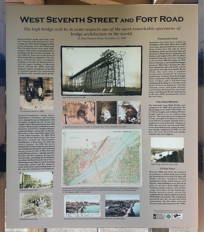
, Shepard Road, parks and trails, and new housing and businesses now occupy one of St. Paul's longest settled areas along the river. Fort Road and West Seventh Street trace early 19th-century trade routes connecting to Fort Snelling and the territory beyond. In the 1840s St. Paul was at the head of Mississippi River navigation. The city grew around the lower steamboat landing at the foot of Jackson Street and the upper landing at Chestnut Street. During the 1860s railroads began to replace steamboats as the link to national markets for agricultural products and manufactured goods., W. 7th Street tavern, ca. 1900., French-Canadians, Irish, Poles, Bohemians, Germans, and Italians were among the European immigrants who founded neighborhoods along the length of Fort Road during the late 19th century. Many people worked in nearby factories, breweries, slaughterhouses, railroad shops, and grain terminals. Breweries were especially important to the early economy: by 1866, West Seventh Street had seven. The Cave Brewery owned by Christopher Stahlmann, a Bavarian, became the state's largest. In 1900 the Jacob Schmidt Brewing Company purchased the Stahlmann property and expanded across across its site at West Seventh and Jefferson streets. Adolph and Otto Bremer led the company during the next decades, including the Prohibition era when the firm brewed "near-beer." Following ownership by other brewing companies, plans call for adaptive reuse of the brew and bottling house at the core of a mixed-use development., Schmidt Brewery, 1905. , Schmidt Brewery, 1938., High Bridge construction, 1889., 1. Sketch of Fountain Cave, ca. 1850. 2. Fountain Cave, 1870. 3. Fountain Cave, 1875., In 1884, densely-built neighborhoods lined West Seventh Street between Toronto Street and Delaware Avenue near the Northwestern Stockyard, the Stahlmann Brewing Company, and railroad shops. (G.M. Hopkins, 1886), Postcard views of Little Italy from the High Bridge, 1902 (left) and 1908 (right).,
Fountain Cave. Fountain Cave has been called the birthplace of St. Paul. More than 11,000 years ago, glacial meltwater carved a deep cavern into the soft St. Peter Sandstone under present-day Shepard Road near Drake Street. Named by the Dakota and explored in 1817 by Major Stephen Long, the cave was estimated to be at least 1,000 feet long. In 1838, Pierre Parrant, a successful bootlegger known as "Pig's Eye," became the city's first inhabitant when he built a shack and saloon near the cave mouth. By the 1850s, the cave was a popular destination featured in tourist guidebooks. Visitors described bright white sandstone walls illuminated by their torches, and a 150-foot-long winding hall leading to a circular room about 50 feet in diameter. Nearby railroad, sewer, and grain elevator construction destroyed the cave landscape, and Shepard Road construction in the late 1950s permanently closed the cave entry.,
The High Bridge. The half-mile long High Bridge was completed in 1889 and spanned the Mississippi to St. Paul's West Side. Its 2,770-foot length and striking 182-foot height ranked it as an engineering marvel. The main span was comprised of four wrought-iron Warren trusses, each 250 feet in length. Rebuilt after a windstorm caused partial collapse in 1904, the structure served until 1984. It was demolished and replaced with a new design completed in 1987 At 160 feet, the new inverted-arch bridge remains the city's highest., High Bridge and Little Italy, 1890.,
Little Italy. Between 1880 and 1959, the isolated area known as Little Italy grew along the flood-prone levee between Elm and Wilkin streets. Southern Italian immigrants built small houses and shacks; some buildings were placed on piles to protect from high water. Gardens, grape arbors, and chicken coops were part of the landscape. Italian grocery stores served the neighborhood, which numbered about 100 families at its peak. The community persisted into the second and third generations, but the entire area was cleared and redeveloped in the 1960s.
... St. Paul, by the vigilance, energy, enterprise and united action of her leading citizens has succeeded in making herself the railroad center and headquarters of the northwestern region ... Railroads are now-a-days the most potent factors in the growth of a city.
Minneapolis Tribune, November 13, 1879
The river's edge west of downtown St. Paul has long supported many types of industry. The area around Randolph Street and Shepard Road was first a center for breweries, factories and railroad shops, followed by power generation and grain storage businesses. A nearby labor force was housed in the West End's densely-built neighborhoods. During the 1930s, the U.S. Army Corps of Engineers transformed the river with projects that deepened and widened the channel for navigation and flood control and also improved barge shipping.
The Omaha Road
In 1881 the Chicago St. Paul Minneapolis and Omaha Railway (CStPM&O) built its West division Shops at Randolph and Drake streets. The brick roundhouse for locomotive repair was the centerpiece of the large complex and was flanked by machine, boiler, and other shops. This railroad
Click or scan to see this page online
company, known as the Omaha Road, was created in 1880 from several smaller railroads. Headquartered in St. Paul, the line carried farm products, lumber, and passengers across 1,700 miles of track in five states. In 1882 the Chicago and Northwestern (C&NW) purchased a controlling interest in the company. The independent Omaha Road was entirely purchased by the C&NW in 1972; in 1995 the C&NW merged into the Union Pacific Railroad.
The shops were cleared in the 1950s for construction of Shepard Road. In 1954 Archer Daniels Midland (ADM) built its Elevator D complex on a portion of the site. The six-story concrete silos provide storage for two million bushels of grain, typically corn, soybeans, and wheat. Grain is loaded to barges as well as Union Pacific Railroad cars.
Omaha Road Swing Bridge
The Omaha Road Swing Bridge Number 15 is the second railroad bridge to span the Mississippi below Randolph Avenue. The previous wood Howe-truss structure was built in 1869 and was one of the original 15 Mississippi River bridges. The CStPM&O and the Chicago, Milwaukee, and St. Paul (CM&StP) railways built the new structure in 1915. The 1,055-foot-long
Photographed by McGhiever, September 4, 2022
2. West Seventh Street and Fort Road Marker
assymetrical design was needed because the 160-foot-wide river channel is not deep enough at this point to accommodate a full-sized bridge. A concrete counterweight keeps both ends of the bridge in balance over the center pier. The bridge is now used by the Canadian Pacific and the Union Pacific railroads.
CStMP&O railroad cars approaching the Wabasha and High bridges, 1895.
The river flats and High Bridge, 1888.
Omaha Shops and Swing Bridge, 1915.
1. Omaha Road ships, 1904 (Sanborn Map) 2. Omaha Road headquarters (1904), 275 W. 4th Street, in 1928. 3. Omaha Road shops, 1950.
Island Power Plant
The St. Paul Gas and Light Company built the Island Station Power plant on the Mississippi River floodplain in 1924, just as coal-burning technology was being modified by new and improved systems. Downriver, the Northern States Power Company (NSP) also built its own High Bridge coal-fired plant in 1924. NSP acquired St. Paul Gas and Light in 1925. After retrofitting, the plant operated from 1926 o 1943 and then was operated below capacity until it was decommissioned. The vacant plant has been the focus of recent proposals for adaptive
Photographed by McGhiever, September 4, 2022
3. Marker kiosk on the Sam Morgan Regional Trail
reuse.
Island Power Plant, 1924.
NSP's coal-burning High Bridge plant, along with the Riverside plant in Minneapolis, was the core of the early Northern States Power Company, the predecessor to Xcel Energy. In 2005 the plant was replaced and a natural gas-fired facility put in service in 2008.
Construction of Northern States Power High Bridge Plant, 1924.
Northern States Power Company employees, 1931.
West Seventh Street and Fort Road
The high bridge will be in some respects one of the most remarkable specimens of bridge architecture in the world.
St. Paul Pioneer Press, November 11, 1888
Shepard Road, parks and trails, and new housing and businesses now occupy one of St. Paul's longest settled areas along the river. Fort Road and West Seventh Street trace early 19th-century trade routes connecting to Fort Snelling and the territory beyond. In the 1840s St. Paul was at the head of Mississippi River navigation. The city grew around the lower steamboat landing at the foot of Jackson Street and the upper landing at Chestnut Street. During the 1860s railroads began to replace steamboats as the link to national markets for agricultural products and manufactured goods.
W. 7th Street tavern, ca. 1900.
French-Canadians, Irish, Poles, Bohemians, Germans, and Italians were among the European immigrants who founded neighborhoods along the length of Fort Road during the late 19th century. Many people worked in nearby factories, breweries, slaughterhouses, railroad shops, and grain terminals. Breweries were especially important to the early economy: by 1866, West Seventh Street had seven. The Cave Brewery owned by Christopher Stahlmann, a Bavarian, became the state's largest. In 1900 the Jacob Schmidt Brewing Company purchased the Stahlmann property and expanded across across its site at West Seventh and Jefferson streets. Adolph and Otto Bremer led the company during the next decades, including the Prohibition era when the firm brewed "near-beer." Following ownership by other brewing companies, plans call for adaptive reuse of the brew and bottling house at the core of a mixed-use development.
Schmidt Brewery, 1905.
Schmidt Brewery, 1938.
High Bridge construction, 1889.
1. Sketch of Fountain Cave, ca. 1850. 2. Fountain Cave, 1870. 3. Fountain Cave, 1875.
In 1884, densely-built neighborhoods lined West Seventh Street between Toronto Street and Delaware Avenue near the Northwestern Stockyard, the Stahlmann Brewing Company, and railroad shops. (G.M. Hopkins, 1886)
Postcard views of Little Italy from the High Bridge, 1902 (left) and 1908 (right).
Fountain Cave
Fountain Cave has been called the birthplace of St. Paul. More than 11,000 years ago, glacial meltwater carved a deep cavern into the soft St. Peter Sandstone under present-day Shepard Road near Drake Street. Named by the Dakota and explored in 1817 by Major Stephen Long, the cave was estimated to be at least 1,000 feet long. In 1838, Pierre Parrant, a successful bootlegger known as "Pig's Eye," became the city's first inhabitant when he built a shack and saloon near the cave mouth. By the 1850s, the cave was a popular destination featured in tourist guidebooks. Visitors described bright white sandstone walls illuminated by their torches, and a 150-foot-long winding hall leading to a circular room about 50 feet in diameter. Nearby railroad, sewer, and grain elevator construction destroyed the cave landscape, and Shepard Road construction in the late 1950s permanently closed the cave entry.
The High Bridge
The half-mile long High Bridge was completed in 1889 and spanned the Mississippi to St. Paul's West Side. Its 2,770-foot length and striking 182-foot height ranked it as an engineering marvel. The main span was comprised of four wrought-iron Warren trusses, each 250 feet in length. Rebuilt after a windstorm caused partial collapse in 1904, the structure served until 1984. It was demolished and replaced with a new design completed in 1987 At 160 feet, the new inverted-arch bridge remains the city's highest.
High Bridge and Little Italy, 1890.
Little Italy
Between 1880 and 1959, the isolated area known as Little Italy grew along the flood-prone levee between Elm and Wilkin streets. Southern Italian immigrants built small houses and shacks; some buildings were placed on piles to protect from high water. Gardens, grape arbors, and chicken coops were part of the landscape. Italian grocery stores served the neighborhood, which numbered about 100 families at its peak. The community persisted into the second and third generations, but the entire area was cleared and redeveloped in the 1960s.
Location. 44° 55.63′ N, 93° 7.168′ W. Marker is in Saint Paul, Minnesota, in Ramsey County. It is in West Seventh - Fort Road. It is on Randolph Avenue near Shepard Road, on the right when traveling east. The marker is at the southeast corner of Randolph Avenue and Shepard Road, along the Sam Morgan Regional Trail. Touch for map. Marker is at or near this postal address: 350 Randolph Avenue, Saint Paul MN 55102, United States of America. Touch for directions.
Regionally, this marker is in the Twin Cities Metropolitan Area. It is also in the American Midwest, in the Corn Belt, and in the Great River Road Region. Globally, it is in North America, the Western Hemisphere, the Western World, and the Anglosphere. Historically, it finds itself in what was once Rupert’s Land, the territory of the Mississippian Culture, and the Louisiana Purchase.
Credits. This page was last revised on February 12, 2023. It was originally submitted on January 11, 2023, by McGhiever of Minneapolis, Minnesota. This page has been viewed 679 times since then and 59 times this year. Photos:1, 2, 3. submitted on January 11, 2023, by McGhiever of Minneapolis, Minnesota. • J. Makali Bruton was the editor who published this page.