Green Valley in Arlington in Arlington County, Virginia — The American South (Mid-Atlantic)
Origins of Green Valley
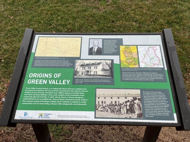
Green Valley, formerly Nauck, is a traditionally African American neighborhood. Levi Jones first settled in this area and was later joined by other African American families such as Thornton and Selina Gray, William Augustus and Ellen Rowe, and Frank and Mary Williams. These early residents set the foundations of the community after the Civil War. In 1876, John D. Nauck, a German immigrant, subdivided 69 acres to establish the "Town of Nauck, Alexandria County, Virginia." The eventual closing of Freedman's Village led to its residents to migrate to nearby communities such as Green Valley, Johnson's Hill, Arlingtonville, and Holmesville.
[Captions:]
Levi Jones was the first African American to own the land in this area. He purchased a 14-acre property in 1844, likely to be closer to Sarah Ann Gardner, his wife, who was enslaved at the nearby Green Valley Manor. The farm consisted of a log cabin and two barns. After Levi's death in 1886, Sarah subdivided the property and conveyed the majority of the land to family.
Anthony Fraser and Presha Lee Fraser built Green Valley Manor in 1821 on what is now the Army-Navy Country Club. Fire destroyed the house in 1924.
William Augustus Rowe was an early resident. In 1876 he purchased five acres from Sewell Corbett for $500. A former enslaved person (according to family history), Rowe was an active member of Freedmen's Village, leader of the Alexandria County Radical Republicans, and elected to numerous political positions.
The arrival of the electric railway (circa 1900) allowed for additional employment opportunities in Rosslyn and Washington, D.C. The expansion of the neighborhood, however, halted as a result of the 1902 Virginia Constitution that restricted the rights of African Americans in Virginia. To accommodate more people, African American landowners began to subdivide their land, but the neighborhood boundaries largely remained unchanged.
The issuance of the Emancipation Proclamation on January 1, 1863, led to an influx of African Americans to the region and prompted the establishment of Freedmen's Village by military officials. Freedman's Village, located on what is now Arlington Cemetery, served as one of the first experiences out of bondage for thousands of African Americans. Originally intended as a temporary accommodation for newly freed enslaved persons, the objective of the camp was to provide its residents protection, education, instruction, and employment. Residents continued to live on the property until the turn of the 20th century.
Erected by Arlington County, Virginia; Arlington Public Schools.
Topics. This historical marker
Location. 38° 50.914′ N, 77° 5.142′ W. Marker is in Arlington, Virginia, in Arlington County. It is in Green Valley. Marker can be reached from South Kenmore STreet just north of 24th Street South, on the right when traveling south. Touch for map. Marker is at or near this postal address: 3436 24th St S, Arlington VA 22206, United States of America. Touch for directions.
Other nearby markers. At least 8 other markers are within walking distance of this marker. Community Businesses (here, next to this marker); Drew School (a few steps from this marker); Places of Worship (a few steps from this marker); Recreation (within shouting distance of this marker); Living and Learning (within shouting distance of this marker); FREED, 2021 (about 400 feet away, measured in a direct line); Macedonia Baptist Church (about 500 feet away); Arlington Lodge 58 (about 500 feet away). Touch for a list and map of all markers in Arlington.
Credits. This page was last revised on February 1, 2023. It was originally submitted on January 22, 2023, by Devry Becker Jones of Washington, District of Columbia. This page has been viewed 164 times since then and 63 times this year. Photos: 1, 2. submitted on January 22, 2023, by Devry Becker Jones of Washington, District of Columbia.

