Marblehead in Essex County, Massachusetts — The American Northeast (New England)
Marblehead Light
Latitude 42 Degrees 30' 20" N
Longitude 70 Degrees 50' 03" W
[Top Marker]
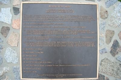
In July of 1789, Representative Elbridge Gerry, native of Marblehead, signer of the Declaration of Independence, and Vice President of the United States under President James Madison, filed H.R. Bill 12 in Congress, officially launching the United States Lighthouse and Navigational Aid System. The Bill passed the House of Representatives on July 20, 1789, and passed the Senate on July 31, 1789. It was signed into law by President George Washington on August 7, 1789.
1831 Town petitioned Congress for lighthouse - $4500 approved
1833 Town bought land - 3.97 acres for $375 - property later transferred to federal government
1835 First light established on July 10 and lit on October 10 - white stone tower with fixed white light, including attached dwelling and covered walkway, 22'3" high and 57' above mean high water - Ezekiel Darling, veteran gunners mate on USS Constitution, first of eleven keepers or "wickies"
1883 Light obscured by newly built surrounding cottages - an adjacent 100' mast erected with lantern hoisted
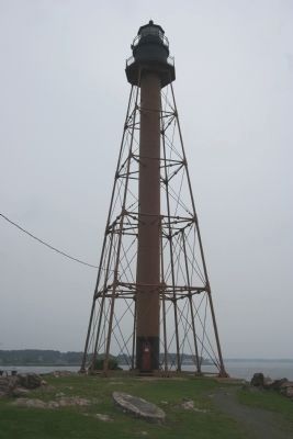
1895 Second light and present lighttower erected - iron, pyramidal skeleton tower, 105' to focal plane and 130' above mean high water with 6th order Fresnel Lens and fixed white light - tower color remains the same today. "Metallic brown with black parapet and black lantern" - only one of its kind in New England - $8786
1896 Lighttower lit on April 17
1910 Light changed to fixed red
1922 Light electrified
1938 Light changed to green
1941 Light extinguished during World War II
1947 Land transferred by federal government to town, through a generous donation by Chandler Hovey
1959 Keepers quarters razed
1960 Light automated
[Bottom Marker]
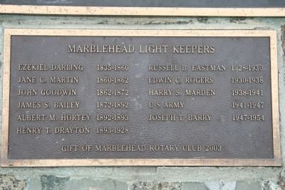
Ezekiel Darling 1835-1860
Jane C. Martin 1860-1862
John Goodwin 1862-1872
James S. Bailey 1872-1892
Albert M. Hortey 1892-1893
Henry T. Drayton 1893-1928
Russell B. Eastman 1928-1930
Edwin C. Rogers 1930-1938
Harry S. Marden 1938-1941
U S Army 1941-1947
Joseph T. Barry 1947-1954
Gift of Marblehead Rotary Club 2003
Erected 1999 by Marblehead 350th Anniversary of Incorporation Fund.
Topics and series. This historical marker is listed in these topic lists: Communications • Landmarks • Waterways & Vessels. In addition, it is included in the Former U.S. Presidents: #04 James Madison series list. A significant historical year for this entry is 1789.
Location. 42° 30.317′ N, 70° 50.013′ W. Marker is in Marblehead, Massachusetts, in Essex County. Marker can be reached from Follett Street, 0 miles north of Kimball Street, on the left. Touch for map. Marker is in this post office area: Marblehead MA 01945, United States of America. Touch for directions.
Other nearby markers. At least 8 other markers are within walking distance of this marker. Huzzah! for "Old Ironsides" (approx. half a mile away); Gen. Casimir Pulaski (approx. half a mile away); Fort Sewall (approx. half a mile away); Fort Sewall Site Plan (approx. half a mile away); a different marker also named Fort Sewall (approx. half a mile away); a different marker also named Fort Sewall (approx. half a mile away); Agnes Surriage Well (approx. 0.7 miles away); Bailey's Head (approx. 0.7 miles away). Touch for a list and map of all markers in Marblehead.
More about this marker. To view this historical marker travel to the end of Highway 129 in Marblehead, turn east onto Ocean Avenue and follow it across the causeway onto Marblehead Neck. Follow Ocean Avenue until it ends at Follett Street. Turn left onto Follett Street, which leads to Chandler Hovey Park where both the Marblehead Lighthouse and this historical marker are located.
Also see . . . Marblehead, MA. This web link is made available by lighthousefriends.com (Submitted on August 8, 2009, by Dale K. Benington of Toledo, Ohio.)
Credits. This page was last revised on September 30, 2020. It was originally submitted on August 8, 2009, by Dale K. Benington of Toledo, Ohio. This page has been viewed 1,176 times since then and 25 times this year. Photos: 1, 2, 3, 4. submitted on August 8, 2009, by Dale K. Benington of Toledo, Ohio. • Kevin W. was the editor who published this page.


