Port Tampa City in Hillsborough County, Florida — The American South (South Atlantic)
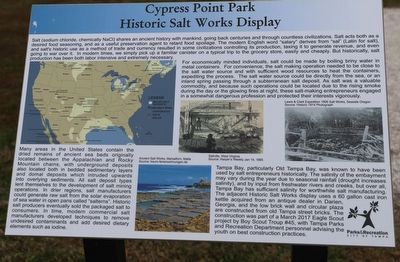
Cypress Point Park Historic Salt Works Display
Salt (sodium chloride, chemically NaCl) shares an ancient history with mankind, going back centuries and through countless civilizations. Salt acts both as a desired food seasoning, and as a useful preservation agent to retard food spoilage. The modern English word "salary” derives from "sal” (Latin for salt), and salt's historic use as a method of trade and currency resulted in some civilizations controlling its production, taxing it to generate revenue, and even going to war over it. In modern times, we simply pick up a familiar canister on a typical trip to the grocery store, easily and cheaply. But historically, salt production has been both labor intensive and extremely necessary.
For economically minded individuals, salt could be made by boiling briny water in metal containers. For convenience, the salt making operation needed to be close to the salt water source and with sufficient wood resources to heat the containers, expediting the process. The salt water source could be directly from the sea, or an inland spring passing through a subterranean salt deposit. As salt was a valuable commodity, and because such operations could be located due to the rising smoke during the day or the glowing fires at night, these salt-making entrepreneurs engaged in a somewhat dangerous profession and protected their interests vigorously.
Many areas in the United States contain the dried remains of ancient sea beds originally located between the Appalachian and Rocky Mountain chains, with underground deposits also located both in bedded sedimentary layers and domal deposits which intruded upwards into overlying sediments. All salt deposit types lent themselves to the development of salt mining operations. In drier regions, salt manufacturers could generate raw salt from the solar evaporation of sea water in open pans called "salterns". Historic salt producers eventually sold the packaged salt to consumers. In time, modern commercial salt manufacturers developed techniques to remove undesired contaminants and add desired dietary elements such as iodine.
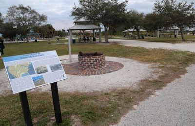
Tampa Bay, particularly Old Tampa Bay, was known to have been used by salt entrepreneurs historically. The salinity of the embayment may vary during the year due to seasonal rainfall (drought increases salinity), and by input from freshwater rivers and creeks, but over all, Tampa Bay has sufficient salinity for worthwhile salt manufacturing. The adjacent Historic Salt Works display uses a 60 gallon cast iron kettle acquired from an antique dealer in Darien, Georgia, and the low brick wall and circular plaza are constructed from old Tampa street bricks. The construction was part of a March 2017 Eagle Scout project by Boy Scout Troup #45, with Tampa Parks and
Recreation Department personnel advising the youth on best construction practices.
Erected by City of Tampa Parks & Recreation.
Topics. This historical marker is listed in these topic lists: Environment • Industry & Commerce • Parks & Recreational Areas • Settlements & Settlers.
Location. 27° 57.056′ N, 82° 32.766′ W. Marker is in Tampa, Florida, in Hillsborough County. It is in Port Tampa City. Marker can be reached from West Cypress Street south of West La Salle Street, on the left when traveling west. Located in Cypress Point Park. Touch for map. Marker is at or near this postal address: 5620 W Cypress St, Tampa FL 33607, United States of America. Touch for directions.
Other nearby markers. At least 8 other markers are within 3 miles of this marker, measured as the crow flies. Hillsborough County World War I War Dead Memorial (approx. 1.1 miles away); Memorial Highway (approx. 1.1 miles away); The Pam Callahan Nature Preserve (approx. 2.3 miles away); Carver City-Lincoln Gardens (approx. 2˝ miles away); W.T. Edwards Hospital Complex (approx. 2.9 miles away); Drew Field (approx. 2.9 miles away); George Guida (approx. 3.1 miles away); William Benton Henderson (approx. 3.1 miles away). Touch for a list and map of all markers in Tampa.
Credits. This page was last revised on January 29, 2023. It was originally submitted on January 29, 2023, by Dave W of Co, Colorado. This page has been viewed 137 times since then and 38 times this year. Photos: 1, 2. submitted on January 29, 2023, by Dave W of Co, Colorado. • Bernard Fisher was the editor who published this page.

