
Upland in Grant County, Indiana — The American Midwest (Great Lakes)
Main Street
Photographed by Craig Doda, January 28, 2023
1. Main Street Marker
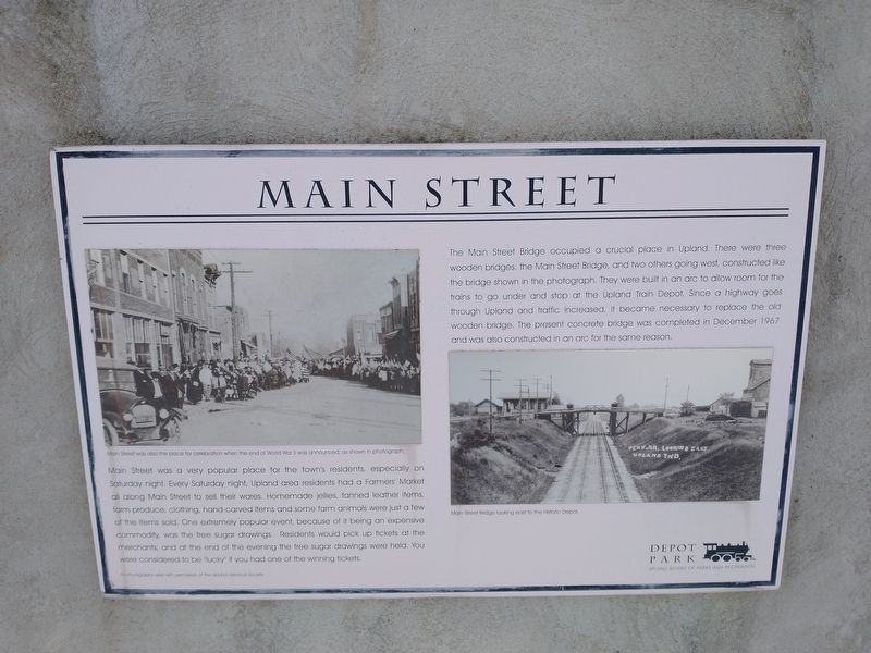
Main Street was a very popular place for the towers residents especially on Saturday night. Every Saturday night, Upland area residents had a Farmers' Market all along Main Street to sell their wares Homemade jellies, tanned leather items, farm produce, clothing, hand-carved items and some farm animals were just a few of the items sold. One extremely popular event, because of it being an expensive commodity was the bee sugar drawings Residents would pick up tickets at the merchants, and at the end of the evening the tree sugar drawings were hold. You wore considered to be lucky if you had one of the winning tickets.
The bridge occupied a crucial place in Upland. These were three wooden bridges: the Main Street Bridge, and two others going west, constructed like the bridge shown in the photograph. They were built in an arc to allow room for the trains to go under and stop at the Upland Train Depot Since a highway goes through Upland and traffic increased, it became necessary to replace the old wooden bridge. The present concrete bridge was completed in December 1967) and was also constructed in an and for the same reason.
Erected by Upland
this page online
Topics. This historical marker is listed in these topic lists: Bridges & Viaducts • Industry & Commerce • Roads & Vehicles. A significant historical month for this entry is December 1967.
Location. 40° 28.444′ N, 85° 29.688′ W. Marker is in Upland, Indiana, in Grant County. It is on South Main Street (Indiana Route 22) south of Railroad Street, on the left when traveling north. Touch for map. Marker is at or near this postal address: 29 Railroad St, Upland IN 46989, United States of America. Touch for directions.

Regionally, this marker is in Central Indiana. It is also in the American Midwest and in the Corn Belt. Globally, it is in North America, the Western Hemisphere, the Western World, and the Anglosphere. Historically, it finds itself in what was once the territory of the Mississippian Culture and also the Northwest Territory.
Other nearby markers. At least 8 other markers are within walking distance of this marker: The Gas Boom (here, next to this marker); The Railroad and Prosperity (here, next to this marker); Taylor University (here, next to this marker); Early Industries in Upland
Photographed by Craig Doda, January 28, 2023
2. Main Street Marker
Credits. This page was last revised on February 8, 2023. It was originally submitted on January 30, 2023, by Craig Doda of Napoleon, Ohio. This page has been viewed 264 times since then and 15 times this year. Photos: 1, 2. submitted on January 30, 2023, by Craig Doda of Napoleon, Ohio. • Devry Becker Jones was the editor who published this page.
