North End in Boston in Suffolk County, Massachusetts — The American Northeast (New England)
Fresh Air and Salt Water
North End
— Harborwalk Boston —
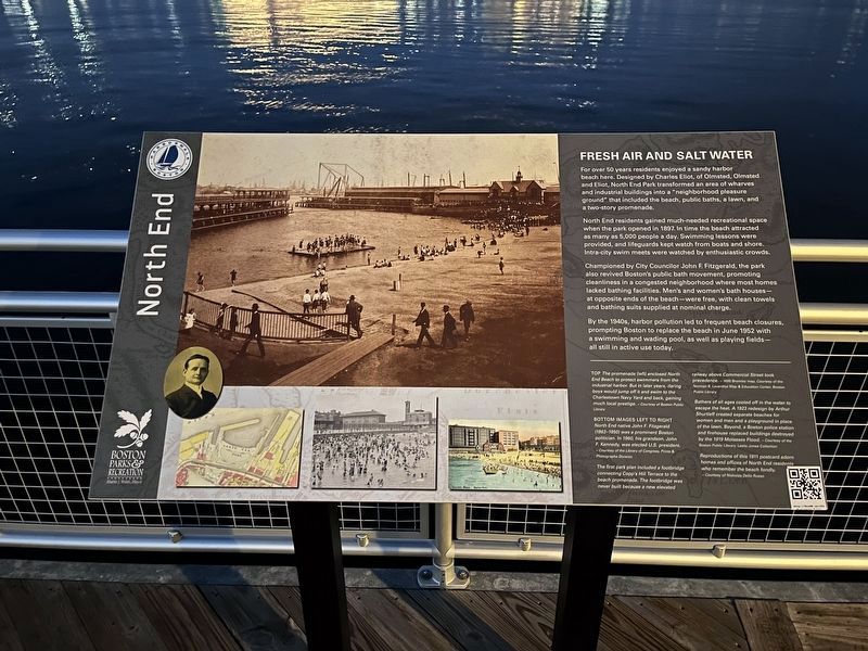
For over 50 years residents enjoyed a sandy harbor beach here. Designed by Charles Eliot, of Olmsted, Olmsted and Eliot, North End Park transformed an area of wharves and industrial buildings into a "neighborhood pleasure ground" that included the beach, public baths, a lawn, and a two-story promenade.
North End residents gained much-needed recreational space when the park opened in 1897. In time the beach attracted as many as 5,000 people a day. Swimming lessons were provided, and lifeguards kept watch from boats and shore. Intra-city swim meets were watched by enthusiastic crowds.
Championed by City Councilor John F. Fitzgerald, the park also revived Boston's public bath movement, promoting cleanliness in a congested neighborhood where most homes lacked bathing facilities. Men's and women's bath houses — at opposite ends of the beach — were free, with clean towels and bathing suits supplied at nominal charge.
By the 1940s, harbor pollution led to frequent beach closures, prompting Boston to replace the beach in June 1952 with a swimming and wading pool, as well as playing fields — all still in active use today.
[Captions:]
Top The promenade (left) enclosed North End Beach to protect swimmers from the industrial harbor. But in later years, daring boys would jump off it and swim to the Charlestown Navy Yard and back, gaining much local prestige.
Bottom images left to right North End native John F. Fitzgerald (1863-1950) was a prominent Boston politician. In 1960, his grandson, John F. Kennedy, was elected U.S. president.
The first park plan included a footbridge connecting Copp's Hill Terrace to the beach promenade. The footbridge was never built because a new elevated railway above Commercial Street took precedence.
Bathers of all ages cooled off in the water to escape the heat. A 1923 redesign by Arthur Shurtleff created separate beaches for women and men and a playground in place of the lawn. Beyond, a Boston police station and firehouse replaced buildings destroyed by the 1919 Molasses Flood.
Reproductions of this 1911 postcard adorn homes and offices of North End residents who remember the beach fondly.
Erected by Boston Parks & Recreation.
Topics and series. This historical marker is listed in these topic lists: Parks & Recreational Areas • Waterways & Vessels. In addition, it is included in the Former U.S. Presidents: #35 John F. Kennedy series list. A significant historical month for this entry is June 1952.
Location. 42° 22.146′ N, 71° 3.301′ W. Marker is in Boston, Massachusetts
Other nearby markers. At least 8 other markers are within walking distance of this marker. Precious Cargo on Board (within shouting distance of this marker); Bocce - More than a Game (within shouting distance of this marker); Boston Molasses Flood (about 300 feet away, measured in a direct line); A Climate Resilient Park (about 500 feet away); The Mathers (about 600 feet away); Seventeenth Century Copp’s Hill (about 700 feet away); African Americans at Copp’s Hill (about 700 feet away); Unusual Gravestones (about 700 feet away). Touch for a list and map of all markers in Boston.
Credits. This page was last revised on January 30, 2023. It was originally submitted on January 30, 2023, by Devry Becker Jones of Washington, District of Columbia. This page has been viewed 61 times since then and 11 times this year. Photos: 1, 2. submitted on January 30, 2023, by Devry Becker Jones of Washington, District of Columbia.
Editor’s want-list for this marker. Clear, daylight photos of the marker and its context. • Can you help?

