Charlevoix in Charlevoix County, Michigan — The American Midwest (Great Lakes)
Fishing and Lumbering - Round Lake, North Shore / Bridge Park and Bridge Street
Inscription.
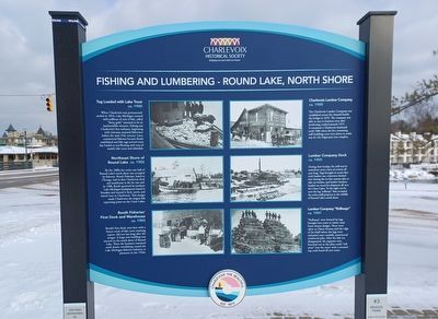
Tug Loaded with Lake Trout
ca. 1900
When Charlevoix was permanently settled in 1854, Lake Michigan teemed with millions of tons of fish, called "finny gold," assumed to be an inexhaustible resource. Fishing was Charlevoix's first industry, beginning with itinerant seasonal fishermen before the mid-19th century. Later, commercial fisheries became firmly established and fish tugs arrived every day loaded to overflowing with tons of mainly lake trout and whitefish.
Charlevoix Lumber Company
ca. 1900
The Charlevoix Lumber Company was established across the channel beside the bridge in 1876. The company was able to stay in business even after lumbering crashed around 1915. It remained a Charlevoix landmark until 1986 when the few remaining mill buildings were torn down to make way for the Edgewater Inn complex.
Northeast Shore of Round Lake
ca. 1905
By the 1880s the entire east half of Round Lake's north shore was occupied by fisheries. Booth Fisheries, based in Chicago, had its first Charlevoix dock and warehouse at the far east end. In 1908, Booth uprooted its northern Lake Michigan headquarters based in Petoskey and moved it lock, stock, and barrel over to Charlevoix. This merger made Charlevoix the largest fish exporting point on the Great Lakes.
Lumber Company Dock
ca. 1905
During their heyday, the mill and its waterfront were a hive of activity all year long. Tugs brought in scows that took lumber out, schooners docked here during the ice-free seasons also to take on lumber, and lumber hookers loaded cut wood for shipment all over the Great Lakes. To the right can be seen the log "rollways" that occupied the entire mill property to the middle of Round Lake's north shore.
Booth Fisheries' First Dock and Warehouse
ca. 1903
Booth's first dock, seen here with a frozen stock of lake trout awaiting export, did not last long after the merger. A huge new building was erected on the south shore of Round Lake. There the business remained until drastic overfishing caused the Lake Michigan fisheries industry to plummet in the 1920s.
Lumber Company "Rollways"
ca. 1907
"Rollways" were formed by logs brought into town in winter atop horse-drawn sledges. These were taken to Dixon Avenue and the edge of the bluff where the logs were unloaded onto carefully constructed reinforced piles. After the lake ice disappeared, the supports were knocked out so the piles could "roll away" into the water with a resounding crash heard all over town.
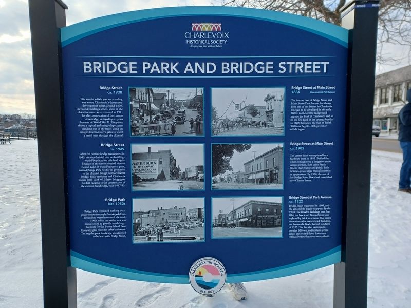
Bridge Street
ca. 1930
This area in which you are standing was where Charlevoix's downtown development began around 1870. The wood buildings at left, some of the oldest in town, were removed in 1941 for the construction of the current drawbridge, delayed by six years because of World War II. The photo shows a typical gathering of spectators standing out in the street along the bridge's lowered safety gates to watch a vessel pass through the channel.
Bridge Street at Main Street
1884 later renamed Park Avenue
The intersection of Bridge Street and Main Street/Park Avenue has always been one of the busiest in Charlevoix. It began to be developed in the early 1880s. In the center background appears the Bank of Charlevoix, said to be the first bank in the county, founded in 1883. Shown is the visit of Josiah Williams Begole, 19th governor of Michigan.
Bridge Street
ca. 1949
After the current bridge was opened in 1949, the city decided that no buildings would be placed on this land again because of the newly revealed view to Round Lake. It would become a park, named Bridge Park not for its proximity to the channel bridge, but for Robert Bridge, bank president and Charlevoix mayor
from 1938-1946. Mayor Bridge gave his full backing to the construction of the current drawbridge, built 1947-49.
Bridge Street at Main Street
ca. 1903
The corner bank was replaced by a hardware store in 1885. Behind the white awning stood a drugstore under various owners, then came Frank Woods' barbershop and public bath facilities, plus a cigar manufacturer in an upper room. By 1900, the rest of this Bridge Street block had been filled in to Clinton Street.
Bridge Park
late 1950s
Bridge Park remained nothing but a grassy empty rectangle that sloped down toward the waterfront until the mid-1990s when the entire area was transformed to provide much larger facilities for the Beaver Island Boat Company plus room for other businesses. The angular park landscape was elevated to be level with Bridge Street.
Bridge Street at Park Avenue
ca. 1922
Bridge Street was paved in 1904, and the automobile began to appear. By the 1920s, the wooden buildings that first filled the block to Clinton Street were replaced by brick structures. This entire three-store-wide corner brick building, the first on the block, burned in March of 1925. The fire also destroyed a popular 600-seat auditorium spread across the second floor. It was not replaced when the stores were rebuilt.
Erected by Charlevoix Historical Society. (Marker Number 3.)
Topics. This historical marker is listed in these topic lists: Industry & Commerce • Roads & Vehicles • Settlements & Settlers • Waterways & Vessels. A significant historical year for this entry is 1854.
Location. 45° 19.099′ N, 85° 15.511′ W. Marker is in Charlevoix, Michigan, in Charlevoix County. Marker is at the intersection of Bridge Street (U.S. 31) and Bridge Park Drive, on the left when traveling south on Bridge Street. Touch for map. Marker is in this post office area: Charlevoix MI 49720, United States of America. Touch for directions.
Other nearby markers. At least 8 other markers are within walking distance of this marker. The Lower Channel Bridges (within shouting distance of this marker); 103 Main Street (now Park Avenue) (about 300 feet away, measured in a direct line); The Harsha House Museum (about 500 feet away); The First Congregational Church (about 600 feet away); Wharfside Building and Park Acquisition (about 700 feet away); Still On Patrol (approx. 0.2 miles away); Benjamin S. Gill, EMC USN (approx. 0.2 miles away); USS Escolar (SS 294) Memorial (approx. 0.2 miles away). Touch for a list and map of all markers in Charlevoix.
Credits. This page was last revised on February 7, 2023. It was originally submitted on February 7, 2023, by Joel Seewald of Madison Heights, Michigan. This page has been viewed 121 times since then and 16 times this year. Photos: 1, 2, 3. submitted on February 7, 2023, by Joel Seewald of Madison Heights, Michigan.


