El Centro in Cartagena de Indias in Municipio de Cartagena, Bolívar, Colombia — Northwestern South America
Proclamation Square

Photographed by James Hulse, February 4, 2023
1. Proclamation Square Marker

Está localizada al frente de la Casa del Cabildo y de la fachada lateral de la Catedral de Cartagena. Ha sido testigo de las proclamas y arengas emitidas desde la Casa del Cabildo, igualmente de las grandes celebraciones religiosas que se han realizado en la Catedral desde su fundación (siglos XVI y XVII). Fue el lugar donde, el 11 de noviembre de 1811, el pueblo reunido respaldó el Acta de Independencia. Hoy se realizan en ella todo tipo de actividades culturales.
Plaza de la Proclamación
Fotografia: Harvin Lewis
English:
Erected by Distrito Turistico, Histórico y Cultural de Cartagena de Indias.
Topics. This historical marker is listed in these topic lists: Architecture • Colonial Era • Patriots & Patriotism • Religion & Religious Structures. A significant historical date for this entry is November 11, 1811.
Location. 10° 25.414′ N, 75° 33.025′ W. Marker is in Cartagena de Indias, Bolívar, in Municipio de Cartagena. It is in El Centro. It is at the intersection of Carrera 5 and Calle 34, on the right when traveling south on Carrera 5. The marker is located on the southeastern corner of the Catedral de Santa Catalina de Alejandría. Touch for map. Marker is at or near this postal address: Cra 5 34-14, Cartagena de Indias, Bolívar 130001, Colombia. Touch for directions.

Regionally, it is on the Caribbean
this page online
Other nearby markers. At least 8 other markers are within walking distance of this marker: The Cathedral Basilica Saint Catherine of Alexandria (within shouting distance of this marker); Bolivar Park (within shouting distance of this marker); Pantaleon German-Ribon Street (within shouting distance of this marker); Simón Bolívar Monument (about 90 meters away, measured in a direct line); Bank of the Republic Building (about 90 meters away); Burn! / La Quemada (about 120 meters away); House of the Inquisition Historical Museum of Cartagena (about 120 meters away); Aduana Square (about 150 meters away). Touch for a list and map of all markers in Cartagena de Indias.

Photographed by James Hulse, February 4, 2023
2. Proclamation Square Marker
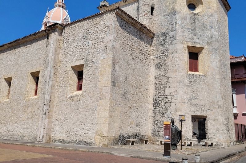
Photographed by James Hulse, February 4, 2023
3. The view of the Proclamation Square Marker
The marker is located at the back of the Cathedral.
Credits. This page was last revised on February 11, 2023. It was originally submitted on February 11, 2023, by James Hulse of Medina, Texas. This page has been viewed 428 times since then and 44 times this year. Photos: 1, 2, 3. submitted on February 11, 2023, by James Hulse of Medina, Texas.
