North Bay in Nipissing District, Ontario — Central Canada (North America)
Gateway of the North Arch
| — | North Bay Heritage Sites | — |
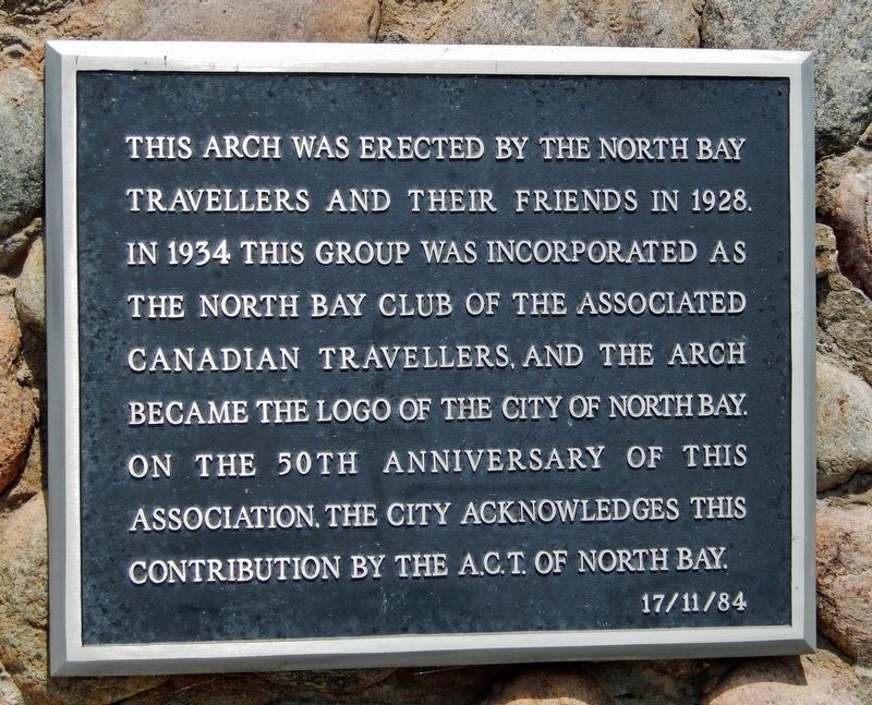
Photographed by Cosmos Mariner, May 31, 2022
1. Gateway of the North Arch Marker
This arch was erected by the North Bay Travellers and their friends in 1928. In 1934 this group was incorporated as the North Bay Club of the Associated Canadian Travellers, and the arch became the logo of the City of North Bay. On the 50th anniversary of this association, the city acknowledges this contribution by the A.C.T. of North Bay.
Erected 1984 by City of North Bay. (Marker Number 22.)
Topics. This historical marker is listed in these topic lists: Landmarks • Roads & Vehicles. A significant historical year for this entry is 1928.
Location. 46° 17.886′ N, 79° 27.43′ W. Marker is in North Bay, Ontario, in Nipissing District. It can be reached from the intersection of Memorial Drive and Colgan Avenue, on the right when traveling north. Marker is mounted at eye-level on the right [east] side of the arch, near the south end of Lee Park. Touch for map. Marker is at or near this postal address: 800 Memorial Drive, North Bay ON P1A 1T6, Canada. Touch for directions.

Regionally, this marker is in Northeastern Ontario and specifically in Northern Ontario. It is also in Central Canada. Globally,
this page online
Other nearby markers. At least 8 other markers are within walking distance of this marker: Jean Nicolet (within shouting distance of this marker); The CF100 Canuck (within shouting distance of this marker); The Bomarc Missile (about 150 meters away, measured in a direct line); Veterans Fields (about 150 meters away); Golf Street / Lee Park (approx. 0.3 kilometers away); New Ontario Brewing Co. Ltd. (approx. 0.7 kilometers away); The Ontario Northland Railway (approx. 0.8 kilometers away); Carnegie Library (approx. 1.3 kilometers away). Touch for a list and map of all markers in North Bay.
Related markers. Click here for a list of markers that are related to this marker. North Bay Heritage Sites
Also see . . .
1. Gateway of the North arch now a heritage site.
The original Gateway of the North project was initiated by the Associated Canadian Travelers,(Submitted on February 14, 2023, by Cosmos Mariner of Cape Canaveral, Florida.)or A.C.T. The Gateway Arch is recognized as a well known landmark in North Bay. The arch once spanned Kennedy Avenue (now Lakeshore Drive), near Judge Avenue. The arch served the dual purpose of welcoming travelers to our region and marking the division point between what was once the Township of West Ferris and the City of North Bay.Photographed by Cosmos Mariner, May 31, 20222. Gateway of the North Arch
Northbound Mileage(mounted on left [west] side of arch)
Kapuskasing • 324
Cochrane • 254
Iroquois Falls • 232
Timmins • 259
Matheson • 206
Kirkland Lake • 171
Swastika • 166
Englehart • 139
New Liskeard • 113
Haileybury • 108
Cobalt • 104
Temagami • 70

2. Gateway Arch.
The Gateway Arch was first constructed in 1928 and spanned Highway 11B (currently Lakeshore Drive), where it acted as a welcome to North Bay and marked the boundary between the city and West Ferris. Although the arch has undergone many alterations and taken different forms, it remains very similar to the original arch that was commissioned by the Association of Canadian Travellers (ACT). The arch was later donated to the City of North Bay by the ACT. The two pillars supporting the arch are made of large, rounded river stones that are held in place with cement mortar. Though it was originally made of wood, the archway is currently made of metal for greater durability. The term and concept of “Gateway(Submitted on February 14, 2023, by Cosmos Mariner of Cape Canaveral, Florida.)to the North” first appeared around the late nineteenth and early twentieth centuries. This term came about due to the realization that North Bay, because of its geographical location, was an inter-connecting link for both north-south and east-west traffic. Although the context for the arch has been changed throughout the years, it remains an icon of the past and an enduring symbol of North Bay’s persona and identity as the “Gateway City.”Photographed by Cosmos Mariner, May 31, 20223. Gateway of the North Arch(looking north • marker on right side, behind fence • restoration in progress at time of photo)

Credits. This page was last revised on February 14, 2023. It was originally submitted on February 11, 2023, by Cosmos Mariner of Cape Canaveral, Florida. This page has been viewed 549 times since then and 55 times this year. Photos: 1, 2, 3. submitted on February 14, 2023, by Cosmos Mariner of Cape Canaveral, Florida.
