
Augusta in Bracken County, Kentucky — The American South (East South Central)
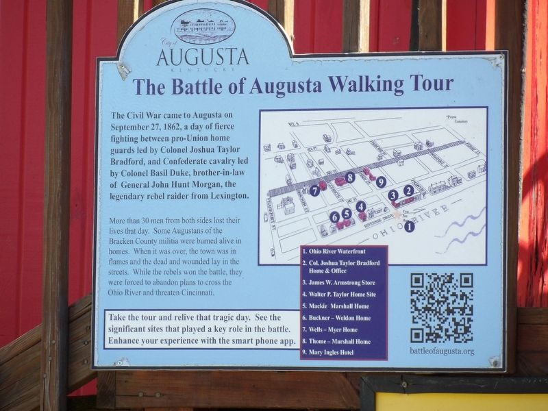
The Battle of Augusta Walking Tour
Photographed by Duane and Tracy Marsteller, April 18, 2019
1. The Battle of Augusta Walking Tour Marker
More than 30 men from both sides lost their lives that day. Some Augustans of the Bracken County militia were burned alive in homes. When it was over, the town was in flames and the dead and wounded lay in the streets. While the rebels won the battle, they were forced to abandon plans to cross the Ohio River and threaten Cincinnati.
Take the tour and relive that tragic day. See the significant sites that played a key role in the battle. Enhance your experience with the smart phone app.
1. Ohio River Waterfront
2. Col. Joshua Taylor Bradfield Home & Office
3. James W. Armstrong Store
4. Walter P. Taylor Home Site
5. Mackie Marshall Home
6. Buckner-Weldon Home
7. Wells-Myer Home
8. Thome-Marshall Home
9. Mary Ingles Hotel
Erected by City of Augusta.
Topics. This historical marker is listed in this topic
this page online
Location. 38° 46.477′ N, 84° 0.473′ W. Marker is in Augusta, Kentucky, in Bracken County. It is at the intersection of East Riverside Drive and Main Street, on the right when traveling east on East Riverside Drive. Touch for map. Marker is at or near this postal address: 100 E Riverside Dr, Augusta KY 41002, United States of America. Touch for directions.

Regionally, this marker is in Kentucky’s Outer Bluegrass. It is also in the American South, specifically in the Upper South, and in the Ohio River Valley. Globally, it is in North America, the Western Hemisphere, the Western World, and the Anglosphere. Historically, it finds itself in what was once the territory of the Mississippian Culture and also the Antebellum South.
Other nearby markers. At least 8 other markers are within walking distance of this marker: James H. Armstrong Store (within shouting distance of this marker); Dr. Joshua T. Bradford Home & Office (within shouting distance of this marker); Welcome To The City Of Augusta Kentucky (about 400 feet away, measured in a direct line); Fort Ancient Village at Augusta / Who Were Fort Ancient People?

Photographed by Duane and Tracy Marsteller, March 4, 2023
2. The Battle of Augusta Walking Tour Marker
Also see . . . Walking Tour for the Battle of Augusta. (Submitted on May 30, 2024.)
Credits. This page was last revised on May 30, 2024. It was originally submitted on March 9, 2023, by Duane and Tracy Marsteller of Murfreesboro, Tennessee. This page has been viewed 696 times since then and 56 times this year. Photos: 1, 2. submitted on March 9, 2023, by Duane and Tracy Marsteller of Murfreesboro, Tennessee.
