Near Moncure in Chatham County, North Carolina — The American South (South Atlantic)
Granville Grant
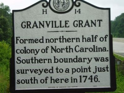
Photographed by Www.ncmarkers.com
1. Granville Grant Marker
Erected 1938 by North Carolina Archives and Highway Departments. (Marker Number H-14.)
Topics and series. This historical marker is listed in these topic lists: Colonial Era • Settlements & Settlers. In addition, it is included in the North Carolina Division of Archives and History series list. A significant historical year for this entry is 1746.
Location. 35° 37.196′ N, 79° 5.581′ W. Marker is near Moncure, North Carolina, in Chatham County. It is on U.S. 1, on the right when traveling north. The location of this marker is US 1 at the Deep River Bridge. Touch for map. Marker is in this post office area: Moncure NC 27559, United States of America. Touch for directions.

Regionally, this marker is in North Carolina’s Piedmont. It is also in the American South and specifically in the Upper South. Globally, it is in North America, the Western Hemisphere, the Western World, and the Anglosphere. Historically, it finds itself in what was once the territory of the Mississippian Culture,
this page online
Other nearby markers. At least 8 other markers are within 9 miles of this marker, measured as the crow flies: Ramsey's Mill (approx. 0.3 miles away); Avent Ferry (approx. 6.2 miles away); Coal Glen Mine Disaster (approx. 6.3 miles away); Tory Raid (approx. 8 miles away); Charles Manly (approx. 8.3 miles away); Lynching in America / Lynching in Chatham County (approx. 8.4 miles away); Law Office of Charles Manly (approx. 8.4 miles away); James I. Waddell (approx. 8½ miles away). Touch for a list and map of all markers in Moncure.
Another marker is no longer nearby. Our Confederate Heroes (was approx. 8.4 miles away but has been permanently removed).
Credits. This page was last revised on March 15, 2023. It was originally submitted on October 16, 2011, by Richard Vogt of Cary, North Carolina. This page has been viewed 776 times since then and 34 times this year. Last updated on March 14, 2023, by Michael Buckner of Durham, North Carolina. Photo 1. submitted on October 16, 2011, by Richard Vogt of Cary, North Carolina. • Bill Pfingsten was the editor who published this page.
