West Point in King William County, Virginia — The American South (Mid-Atlantic)
The Grove Hotel
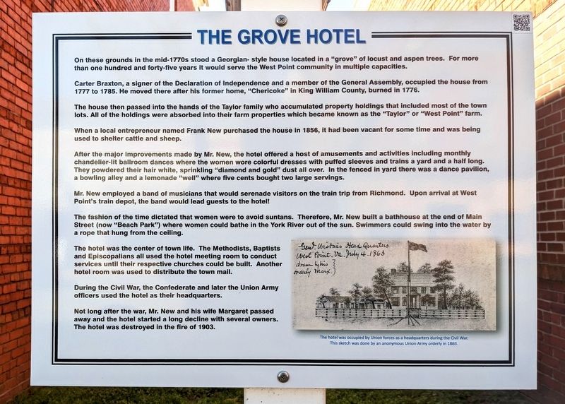
On these grounds in the mid-1770s stood a Georgian-style house located in a "grove" of locust and aspen trees. For more than one hundred and forty-five years it would serve the West Point community in multiple capacities.
Carter Braxton, a signer of the Declaration of Independence and a member of the General Assembly, occupied the house from 1777 to 1785. He moved there after his former home, "Chericoke" in King William County, burned in 1776.
The house then passed into the hands of the Taylor family who accumulated property holdings that included most of the town lots. All of the holdings were absorbed into their farm properties which became known as the "Taylor" or "West Point" farm.
When a local entrepreneur named Frank New purchased the house in 1856, it had been vacant for some time and was being used to shelter cattle and sheep.
After the major improvements made by Mr. New, the hotel offered a host of amusements and activities including monthly chandelier-lit ballroom dances where the women wore colorful dresses with puffed sleeves and trains a yard and a half long. They powdered their hair white, sprinkling "diamond and gold" dust all over. In the fenced in yard there was a dance pavilion, a bowling alley and a lemonade "well" where five cents bought two large servings.
Mr. New employed a band of musicians that would serenade visitors on the train trip from Richmond. Upon arrival at West Point's train depot, the band would lead guests to the hotel!
The fashion of the time dictated that women were to avoid suntans. Therefore, Mr. New built a bathhouse at the end of Main Street (now "Beach Park") where women could bathe in the York River out of the sun. Swimmers could swing into the water by a rope that hung from the ceiling.
The hotel was the center of town life. The Methodists, Baptists and Episcopalians all used the hotel meeting room to conduct services until their respective churches could be built. Another hotel room was used to distribute the town mail.
During the Civil War, the Confederate and later the Union Army officers used the hotel as their headquarters.
Not long after the war, Mr. New and his wife Margaret passed away and the hotel started a long decline with several owners. The hotel was destroyed in the fire of 1903.
(caption) The hotel was occupied by Union forces as a headquarters during the Civil War. This sketch was done by an anonymous Union Army orderly in 1863.
Erected by Historical Society of West Point.
Topics. This historical marker is listed in these topic lists: Entertainment • Industry & Commerce • War, US Civil.
Location. 37° 31.919′ N, 76° 47.804′ W. Marker is in West Point, Virginia, in King William County. Marker is on Main Street south of 8th Street, on the right when traveling south. Touch for map. Marker is at or near this postal address: 715 Main St, West Point VA 23181, United States of America. Touch for directions.
Other nearby markers. At least 8 other markers are within walking distance of this marker. L. E. Mumford Banking Company (a few steps from this marker); Col. John West II (approx. 0.2 miles away); Mt. Nebo Baptist Church (approx. 0.3 miles away); Lt. General Lewis "Chesty" Puller (USMC) (approx. 0.4 miles away); Lt. Gen. Lewis Burwell “Chesty” Puller (approx. 0.4 miles away); Home of Signer (approx. 0.4 miles away); The Terminal Hotel (approx. 0.4 miles away); Lieutenant General Lewis B. Puller (approx. 0.4 miles away). Touch for a list and map of all markers in West Point.
Also see . . . Historical Society of West Point. (Submitted on March 15, 2023.)
Credits. This page was last revised on March 15, 2023. It was originally submitted on March 15, 2023, by Bernard Fisher of Richmond, Virginia. This page has been viewed 113 times since then and 28 times this year. Photos: 1, 2. submitted on March 15, 2023, by Bernard Fisher of Richmond, Virginia.

