Centreville in Fairfax County, Virginia — The American South (Mid-Atlantic)
Historic Centreville Park
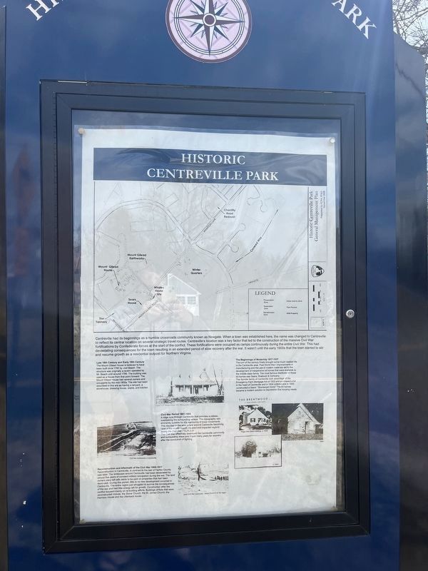
Centreville had its beginnings as a humble crossroads community known as Newgate. When a town was established here, the name was changed to Centreville to reflect its central location on several strategic travel routes. Centreville's location was a key factor that led to the construction of the massive Civil War fortifications by Confederate forces at the start of the conflict. These fortifications were occupied as camps continuously during the entire Civil War. This had devastating consequences for the town resulting in an extended period of slow recovery after the war. It wasn't until the early 1900s that the town started to stir and resume growth as a residential outpost for Northern Virginia.
Late 18th Century and Early 19th Century
The Mount Gilead House is believed to have been built circa 1785 by Joel Beach. The structure was originally a tavern operated by Mr. Beach until around 1789. The building was used as a house from that point forward. The Mount Gilead House had several owners and occupants by the mid-1800s. The site had been described in this era as having a tanyard, a storehouse, dressing house, stable, and kitchen.
Civil War Period 1861-1865
A ridge runs through Centreville that provides a plateau overlooking the surrounding valleys. This topography was eminently suitable for the monitoring of troop movements. This resulted in the area in and around Centreville becoming "one of the mostly heavily traveled and impacted regions during the Civil War." CLR 2-21
The Civil War effectively destroyed the Centreville community and surrounding areas and it took many years for recovery after the conclusion of fighting.
Reconstruction and Aftermath of the Civil War 1865-1917
Reconstruction in Centreville, in contrast to the rest of Fairfax County, was slow. The landscape around Centreville had been devastated by almost five years of constant military occupation during the war. The land owners were left with debts to be paid on properties that had been destroyed. During this period, little to no new development occurred in Centreville. The entire region just struggled to survive the consequences of the war and had little energy left for growth. Construction after the conflict focused mainly on re-building efforts. Buildings of note that were reconstructed include: the Stone Church; the St. James Church; the Harrison House and the Utterback house.
The Beginnings of Modernity 1917-1937
The turn of the century finally brought some much needed life to the Centreville area. Post World War I improvements in manufacturing and the use of modern materials led to the development of inexpensive kit
The Spindle family of Centreville took advantage of the Emergency Mortgage Act of 1933 and purchased a lot in the heart of Centreville and in 1934 ordered and in 1935 constructed a Sears " Brentwood Home" The kit homes became a modern solution to Depression Era housing needs.
Erected by Fairfax County Park Authority.
Topics. This historical marker is listed in these topic lists: Forts and Castles • Industry & Commerce • Settlements & Settlers • War, US Civil. A significant historical year for this entry is 1785.
Location. 38° 50.465′ N, 77° 25.664′ W. Marker is in Centreville, Virginia, in Fairfax County. Marker is on Mount Gilead Road, 0.1 miles north of Braddock Road, on the right when traveling north. Touch for map. Marker is at or near this postal address: 5715 Mt Gilead Rd, Centreville VA 20120, United States of America. Touch for directions.
Other nearby markers. At least 8 other markers are within walking distance of this marker. St. John's Episcopal Church (about 300 feet away, measured in a direct line); a different marker also named St. John's Episcopal Church (about 400 feet away); Harrison House (about 500 feet away); Newgate Tavern (about 500 feet away); Convicts and Slaves (about 500 feet away); Archaeology at Newgate Tavern (about 500 feet away); Minnie Minter Carter Saunders (about 500 feet away); Mount Gilead (about 600 feet away). Touch for a list and map of all markers in Centreville.
Credits. This page was last revised on March 18, 2023. It was originally submitted on March 18, 2023, by Devry Becker Jones of Washington, District of Columbia. This page has been viewed 116 times since then and 22 times this year. Photos: 1, 2. submitted on March 18, 2023, by Devry Becker Jones of Washington, District of Columbia.

