Bradenton in Manatee County, Florida — The American South (South Atlantic)
The Civil War
Reflections of Manatee
— The History of Manatee Flows from this Spring —
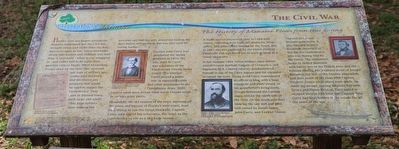
Battles were not fought around the Manatee settlement, but the Civil War brought stress and stain none-the-less. Men went away to war. Union blockades meant that women and children only had flour occasionally – when it was smuggled in – and coffee has to be made from parched corn or beans. When blockading troops came up the river they arrested any men of military age, confiscated livestock. And destroyed any property that might be used to supply the Confederacy. They sunk or burned boats, both large and small. They kept settlers from making the precious salt that not only preserved food in the days before refrigeration, but was also vital for curing leather.
Captain John Curry had purchased the Spring property in 1859. His son, John W. Curry, was a member of the Confederate Florida Home Guard. The younger Curry played a major role in supplying cattle and other provisions to the Confederate Army. 2000 cattle a week were driven from south Florida north to various army posts.
Meanwhile, the old seamen of the town, knowing all the inlets and bayous of Florida’s west coast, kept busy trying to run the Union blockade. Captain Curry sold one of his schooners, the Ariel to the Confederacy to use as a blockade runner.
It made several successful runs to Cuba with cotton, returning with lead, tin, medicine, wine, coffee, and other items needed by the South. But, in 1862 she was captured by the Union steamer Huntsville and was fitted out to work instead as a Union blockader.
In late summer 1864, Union soldiers came ashore. Joseph Francis Bartholf, Captain of Company I, 2nd Regiment, U.S. Colored Infantry, headquartered himself at one of the Curry houses and the regiment occupied the town. Young Avid Curry remembered an officer in blue, with a huge mustache and shiny sword, in his grandfather’s living room. Troops destroyed the Gamble sugar mill on the north side of the river. On the south side they blew up the saw mill and first mill owned by Josiah Gates, John Curry, and Ezekiel Glazer.
The end of the war brought men home. It also brought Judah P. Benjamin, Secretary of War for the Confederacy, who was fleeing trial by the Union. The settlement, home to killed boatmen with family ties to the Florida Keys and the Bahama Islands was a natural point of escape. Benjamin hid first at the Gamble plantation, and then south of the river with Captain Frederic Tresca while plans were made. He made his escape, leaving Sarasota Bay with Tresca and Hiram McLeod. They sailed in an open sixteen foot boat that Captain John Curry had kept hidden in the woods for all the tears of the war.
Erected by Florida Humanities Council
.
Topics. This historical marker is listed in these topic lists: Settlements & Settlers • War, US Civil • Waterways & Vessels. A significant historical year for this entry is 1859.
Location. 27° 29.773′ N, 82° 32.974′ W. Marker is in Bradenton, Florida, in Manatee County. Marker is on 4th Avenue East east of 12th Street East, on the right when traveling east. Touch for map. Marker is at or near this postal address: 1306 4th Ave E, Bradenton FL 34208, United States of America. Touch for directions.
Other nearby markers. At least 8 other markers are within walking distance of this marker. Curry Houses National Register Historic District / Refuge of Peace (here, next to this marker); Curry House Circa 1860 (a few steps from this marker); Curry Family (a few steps from this marker); Mary Amelia Curry House (a few steps from this marker); Theodosia Curry Lloyd House (within shouting distance of this marker); The Florida Cracker Trail (about 500 feet away, measured in a direct line); Old Cabbage Head (about 600 feet away); The Wiggins Store (about 600 feet away). Touch for a list and map of all markers in Bradenton.
Also see . . . Reflections of Manatee. (Submitted on March 22, 2023.)
Credits. This page was last revised on March 23, 2023. It was originally submitted on March 20, 2023, by Dave W of Co, Colorado. This page has been viewed 120 times since then and 34 times this year. Photos: 1, 2. submitted on March 20, 2023, by Dave W of Co, Colorado. • Bernard Fisher was the editor who published this page.

