Jerusalem, Israel — West Asia (the Levant in the Middle East)
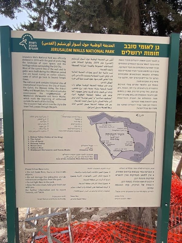
Jerusalem Walls National Park
The national park contains historical sites of International importance: the City of David, the Ophel, the Hinnom Valley, the Kidron Valley and Mount Zion. The national park also the neighborhoods of Mishkenot She'ananim and Yemin Moshe, which mark the beginning of settlement outside the walls of the Old City.
The Jerusalem Trail, which links the city to the Israel Trail, passes through the park.
Map Legend
1. Kidron Valley (Valley of the King 2. The Ophel 3. City of David 4. Hinnom Valley 5. Mount Zion 6. Sultan's Pool T 7. Mishkenot She'ananim and Yamin Moshe
Please follow these rules: Do not harm flora, fauna or inanimate objects.
Do not damage the antiquities and do not remove antiquities from the park.
Do not light fires in the park.
Keep the area clean; take your trash out with you.
For further information and to report hazards, call 3639.
Enjoy your visit!
Israel Nature and Parks Authority
Topics. This historical marker is listed in this topic list: Parks & Recreational Areas.
Location. 31° 46.208′ N, 35° 13.772′ E. Marker is in Jerusalem, Israel. Marker is on Ma'ale HaShalom Street, on the left when traveling west. Touch for map. Marker is at or near this postal address: Ma'ale HaShalom Street, Jerusalem, Israel, Israel. Touch for directions.
Other nearby markers. At least 8 other markers are within walking distance of this marker. Tribute to Poles who died on the way to their homeland in the years after WWII and after (about 120 meters away, measured in a direct line); King David's Tomb (about 150 meters away); The Dajani Cemetery on Mount Zion (about 180 meters away in Jerusalem District); a different marker also named King David's Tomb (about 180 meters away); Room of the Last Supper (about 210 meters away); Count Amedee de Piellat (1852-1925) (approx. 0.2 kilometers away in Jerusalem District); Fr. Etienne Boubet, assumptionist, (1865-1934) (approx. 0.2 kilometers away in Jerusalem District); Tomb of French Pilgrims / Caveau des Pèlerins Francais (approx. 0.2 kilometers away in Jerusalem District). Touch for a list and map of all markers in Jerusalem.
Credits. This page was last revised on May 7, 2023. It was originally submitted on March 28, 2023, by Darren Jefferson Clay of Duluth, Georgia. This page has been viewed 76 times since then and 18 times this year. Photos: 1, 2. submitted on March 28, 2023, by Darren Jefferson Clay of Duluth, Georgia. • Andrew Ruppenstein was the editor who published this page.

