Winchester, Virginia — The American South (Mid-Atlantic)
The Second Battle of Kernstown
Two Future U.S. Presidents Fought at Kernstown
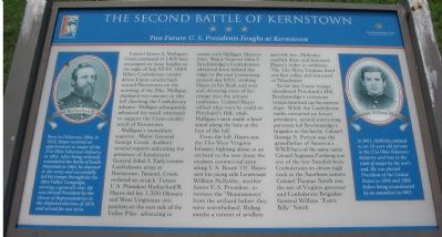
Mulligan’s immediate superior, Major General George Crook, doubted several reports indicating the presence of Lieutenant General Jubal A. Early’s entire Confederate army at Kernstown. Instead, Crook ordered an attack. Future U.S. President Rutherford B. Hayes led his 1,300 Ohioans and West Virginians into position on the east side of the Valley Pike, advancing in unison with Mulligan. Minutes later, Major General John C. Breckinridge's Confederates advanced from behind the ridge to the east (containing present-day I-81), striking Hayes in his flank and rear and throwing most of his troops into the utmost confusion. Colonel Hayes rallied what men he could on Pritchard’s Hill, while Mulligan’s men made a brief stand along the lane at the foot of the hill.
From the hill, Hayes saw the 13th West Virginia Infantry fighting alone in an orchard to the east (near the modern commercial area along U.S. Route 11). Hayes sent his young aide Lieutenant William McKinley, another future U.S. President, to retrieve the “Mountaineers” from the orchard before they were overwhelmed. Riding amidst a torrent of artillery and rifle fire, McKinley reached them and delivered Hayes’s order to withdraw. The 13th West Virginia fired one last volley and retreated to Winchester.
As the last Union troops abandoned Pritchard’s Hill, Breckinridge’s victorious troops swarmed up the eastern slope. While the Confederate ranks contained no future presidents, several interesting personas led Breckinridge’s brigades in battle. Colonel George S. Patton was the grandfather of America’s WWII hero of the same name. Colonel Augustus Forsberg was one of the few Swedish-born Confederates to obtain high rank in the Southern armies. Colonel Thomas Smith was the son of Virginia governor and Confederate Brigadier General William “Extra Billy” Smith.
(Left Sidebar, with portrait of Colonel Rutherford B. Hayes): Born in Delaware, Ohio in 1822, Hayes received an appointment as a major of the 23rd Ohio Volunteer Infantry in 1861. After being seriously wounded at the Battle of South Mountain in 1862, he returned to the army and successfully led his troops throughout the 1864 Valley Campaign, earning a general’s star. He was elected President by the House of Representatives in the disputed election of 1876 and served for one term.
(Right
Sidebar, with portrait of Lieutenant William McKinley): In 1861, McKinley enlisted as an 18-year-old private in the 23rd Ohio Volunteer Infantry and rose to the rank of major by the war’s end. He was elected President of the United States in 1896 and 1900 before being assassinated by an anarchist in 1901.
Erected by Shenandoah Valley Battlefields National Historic District.
Topics and series. This historical marker is listed in this topic list: War, US Civil. In addition, it is included in the Former U.S. Presidents: #19 Rutherford B. Hayes, and the Former U.S. Presidents: #25 William McKinley series lists. A significant historical date for this entry is July 23, 1848.
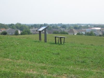
Location. This marker has been replaced by another marker nearby. It was located near 39° 8.725′ N, 78° 11.703′ W. Marker was in Winchester, Virginia. Marker could be reached from Battle Park Drive, on the right when traveling west. Located in the Pritchard-Grim Farm, Kernstown Battlefield, on Pritchard Hill. Touch for map. Marker was at or near this postal address: 610 Battle Park Drive, Winchester VA 22604, United States of America. Touch for directions.
Other nearby markers. At least 8 other markers are within walking distance of this location. Second Battle of Winchester (about 500 feet away, measured in a direct line); a different marker also named The Second Battle of Kernstown (about 500 feet away); The First Battle of Kernstown
(about 600 feet away); The Pritchard House (approx. 0.2 miles away); a different marker also named The First Battle of Kernstown (approx. 0.2 miles away); a different marker also named The Second Battle of Kernstown (approx. 0.2 miles away); Kernstown Battlefield (approx. 0.2 miles away); a different marker also named Second Battle of Kernstown (approx. 0.2 miles away). Touch for a list and map of all markers in Winchester.
Related marker. Click here for another marker that is related to this marker. This marker has been replaced by the linked marker.
Also see . . .
1. Kernstown Battlefield Association. (Submitted on August 29, 2007, by Craig Swain of Leesburg, Virginia.)
2. Second Battle of Kernstown. From a National Parks Service survey of the Civil War battles in the Shenandoah Valley. (Submitted on August 29, 2007, by Craig Swain of Leesburg, Virginia.)
Credits. This page was last revised on November 2, 2020. It was originally submitted on August 29, 2007. This page has been viewed 2,126 times since then and 27 times this year. Last updated on August 14, 2020, by Bradley Owen of Morgantown, West Virginia. Photos: 1, 2. submitted on August 29, 2007, by Craig Swain of Leesburg, Virginia. 3. submitted on November 26, 2010, by Bill Coughlin of Woodland Park, New Jersey. 4. submitted on August 29, 2007, by Craig Swain of Leesburg, Virginia. • J. Makali Bruton was the editor who published this page.


