Edgewater in Anne Arundel County, Maryland — The American Northeast (Mid-Atlantic)
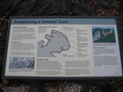
Establishing a Colonial Town
Photographed by F. Robby, November 7, 2007
1. Establishing a Colonial Town Marker
Scattered Settlements
Early Chesapeake Bay colonists did not settle in the concentrated villages typical of their home in England. Instead, they lived on large plots of waterfront land that isolated them from their neighbors.
Cheap and abundant property along the Bay and its rivers, provided tobacco farmers with easy access to water for transportation of their crop. These dispersed settlements made it difficult for the English governors to monitor trade and collect taxes on goods sent from the colonies.
A Town Plan
The Maryland colonial government attempted to control trade by passing several Town Acts which established official ports of entry where Taxes could be collected. The 1683 Town Act that created London Town specified 100 one-acre lots and nearly a dozen streets on land provided by William Burgess.
Though no map of the town survives today, a recreation of the original town plan is being pieced together using historical documents and archaeology.
London Town and Its People
This map shows the roads of London Town and the locations of important buildings and businesses. The present day park is outlined
this page online
Tavern A tavern was operated on Scott Street by Edward and Elinor Rumney from the 1690s to 1720s and later by Stephen West.
Ferries Edward Rumney operated a ferry from the foot of Scott Street starting in 1715.
David Macklefish operated the first ferry from this lot starting in the 1680s.
Courthouse The 25 x 25 Anne Arundel County courthouse - the cage, whipping post, pillory and stone used for punishing prisoners, stood in this vicinity from 1684 to 1695.
Slave Quarter/Carpenter Shop African slaves occupied this lot in the 1730s. Later the house became a carpenter shop, used by William Brown.
Storehouse Merchant Samuel Peele ran a storehouse here from 1715 to 1733.
Warehouse A brick warehouse owned by James Dick stood along this shore in the 1760s.
Ropewalk Stephen West, Jr. and James Dick opened a ropewalk here in 1747.
An Urban Center
Merchants, sea captains, planters, indentured servants, and slaves quickly transformed London Town into a bustling port of houses, ferries, store houses, taverns, warehouses, and workshops. Nearly 50 London Town lots were occupied by the 1740s. The town became one
Photographed by F. Robby, July 23, 2009
2. Establishing a Colonial Town Marker
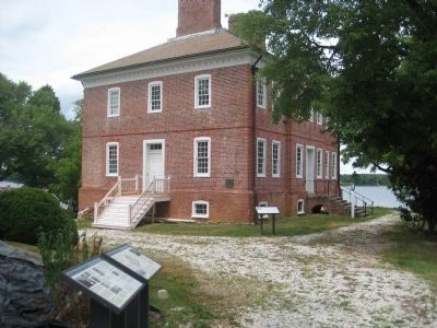
This marker is to second one from the left. The brick William Brown House is in the background.
Each fall, the town's population ebbed and flowed with the arrival of tobacco fleets awaiting delivery of the tobacco crop from outlying plantations.
The active seaport suffered a blow in 1747 when the Maryland legislature did not select London Town as an official tobacco inspection station. The Tobacco Inspection Acts required that all tobacco grown in Maryland be shipped from designated stations.
The tobacco trade went elsewhere and the town slowly slid into decline. Travelers continued to use the ferry crossing, but the once vital urban center faded from the landscape with only a few houses left standing in the 20th century.
History Underfoot
The ravine behind you was Scott Street, London Town's busiest street and a colonial highway. Scott Street was home to many thriving shops and taverns which once stood where you are standing now.
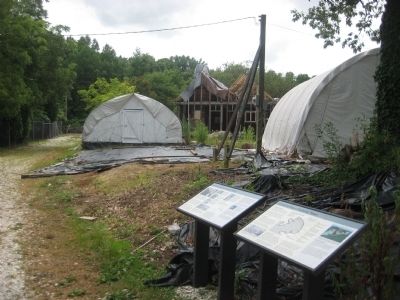
Edward Rumney, a boat building by trade, operated both a tavern and a ferry. Remains of the tavern are located in the tent in front of you. Stephen West, Sr. took over the Rumney tavern in 1724. Later
Photographed by F. Robby, July 23, 2009
3. Rumney Tavern Location
The marker says the tent on the right in this picture is the location of the Rumney Tavern, currently an active archaeological dig site.
[Captions:]
Colonial Tobacco Wharf: Detail from Joshua Fry and Peter Jefferson, A Map of the most inhabited part of Virginia containing the whole Province of Maryland, 1751.
Scott Street: A digital reconstruction of Scott Street showing (from left to right) William Brown's carpenter shop, an unidentified building, the Rumney-West Tavern and the William Brown House.
Topics. This historical marker is listed in these topic lists: Colonial Era • Industry & Commerce • Settlements & Settlers. A significant historical year for this entry is 1683.
Location. This marker has been replaced by another marker nearby. It was located near 38° 56.471′ N, 76° 32.384′ W. Marker was in Edgewater, Maryland, in Anne Arundel County. It could be reached from Londontown Road 1.3 miles north of Mayo Road (Route 253). Marker is on the grounds of London Town Park, at the end of Londowntown Road, near the brick house. Touch for map. Marker was in this post office area: Edgewater MD 21037, United States of America. Touch for directions.

Regionally, this marker was in Central Maryland. It was also in the American Mid-Atlantic, in the Chesapeake Bay Region, and on the Eastern Seaboard. Globally, it was in the North Atlantic Region, North America, the Western Hemisphere, the Western World, and the Anglosphere. Historically, it found itself in what was once one of the original Thirteen Colonies and also the Antebellum South.
Other nearby markers. At least 8 other markers are within walking distance of this location: William Brown House (here, next to this marker); The Almshouse (a few steps from this marker); Scott Street (a few steps from this marker); The Carpenter's Shop (within shouting distance of this marker); Slavery at London Town (within shouting distance of this marker); The South River (within shouting distance of this marker); London Town Ferry (within shouting distance of this marker); Tobacco Barn (within shouting distance of this marker). Touch for a list and map of all markers in Edgewater.
Other markers no longer nearby. Archaeology at London Town (was here, next to this marker but has been replaced with another marker now near it); a different marker also named William Brown House (was a few steps from this marker but has been replaced with another marker now near it); Dr. Hill's Medicinal Plants (was within shouting distance of this marker but has been replaced with another marker now near it); The Lord Mayor's Tenement (was within shouting distance of this marker but has been replaced with another marker now near it); The Ferry at London Town (was within shouting distance of this marker but has been replaced with another marker now near it).
Credits. This page was last revised on August 1, 2026. It was originally submitted on September 2, 2009, by F. Robby of Baltimore, Maryland. This page has been viewed 1,714 times since then and 68 times this year. Photos: 1, 2, 3. submitted on September 2, 2009, by F. Robby of Baltimore, Maryland.
