Edgewater in Anne Arundel County, Maryland — The American Northeast (Mid-Atlantic)
The Lord Mayor's Tenement
Photographed by F. Robby, November 7, 2007
1. The Lord Mayor's Tenement Marker
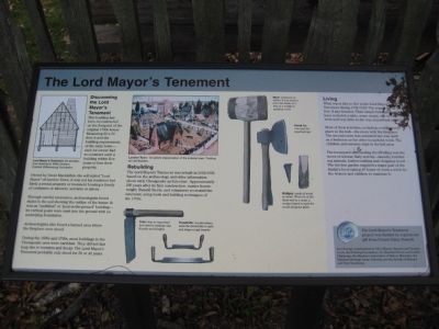
Discovering the Lord Mayor's Tenement
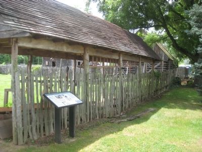
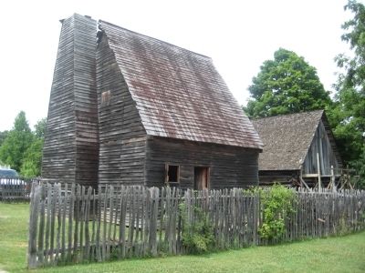
This building has been reconstructed on the footprint of the original 1700s house. Measuring 20 x 20 feet, it met the building requirements of the early town - each lot owner had to construct such a building within five years or lose their property.
Owned by David Macklefish, the self-styled "Lord Mayor" of London Town, it was not his residence but likely a rental property or tenement housing a family or craftsmen or laborers, servants or slaves.
Through careful excavation, archaeologists found stains in the soil showing the outline of the house. It was an "earthfast" or "post-in-the-ground" building - its vertical posts were sunk into the ground with no underlying foundation.
Archaeologists also found a burned area where the fireplace once stood.
During the 1600s and 1700s, most buildings in the Chesapeake area were earthfast. They did not last long due to termites and decay. The Lord Mayor's Tenement probably only stood for 30 or 40 years.
Rebuilding
The Lord Mayor's Tenement was rebuilt in 2002-2003, based on the archaeology and other information about early Chesapeake
this page online
Living
What was it like to live in the Lord Mayor's Tenement during 1700-1720? The tenant family had few, if any luxuries. Their simple belonging might have included a table, some chairs, one or two beds and very little in the way of personal objects.
Most of their activities, including cooking took place in the hall - the room with the fireplace. The second room was unheated but was used as a bedroom or for other household work. The children and servants slept in the loft area.
The houseyard surrounding the dwelling was the scene of intense daily activity - laundry, butchering animals, leather-crafting and chopping wood. The kitchen garden supplies a major part of the family's food; taking 40 hours of work a week by the women and children to maintain it.
The Lord Mayor's Tenement project was funded by a generous gift from Donna Valley Russell.
And through contributions by Alice Murray, Bernard and Victoria Lerch, the Frohring
Photographed by F. Robby, July 23, 2009
2. The Lord Mayor's Tenement Marker
[Captions:]
Lord Mayor's Tenement: An architectural drawing by Willie Graham, Colonial Williamsburg Foundation.
London Town: An artist's interpretation of the colonial town. Painting by Lee Boynton.
Froe: was an important tool used in making clapboards and shingles.
Drawknife: woodworkers used the drawknife to split and shape rough boards.
Maul: a hammer or mallet. It was used to drive the blade of a froe or a wedge in splitting wood.
Broad Ax: was used for squaring logs.
Wedges: made of wood or metal. When hit at the thick end by a maul, a wedge helped to split the wood along the grain.
Topics. This historical marker is listed in these topic lists: Colonial Era • Settlements & Settlers.
Location. This marker has been replaced by another marker nearby. It was located near 38° 56.472′ N, 76° 32.41′ W. Marker was in Edgewater, Maryland, in Anne Arundel County. It could be reached from
Photographed by F. Robby, July 23, 2009
3. The Lord Mayor's Tenement

Regionally, this marker was in Central Maryland. It was also in the American Mid-Atlantic, in the Chesapeake Bay Region, and on the Eastern Seaboard. Globally, it was in the North Atlantic Region, North America, the Western Hemisphere, the Western World, and the Anglosphere. Historically, it found itself in what was once one of the original Thirteen Colonies and also the Antebellum South.
Other nearby markers. At least 8 other markers are within walking distance of this location: Tobacco Barn (within shouting distance of this marker); The Tenement (within shouting distance of this marker); William Brown House (within shouting distance of this marker); The Almshouse (within shouting distance of this marker); The Carpenter's Shop (within shouting distance of this marker); Welcome to London Town (within shouting distance of this marker); Scott Street (within shouting distance of this marker); London Town Ferry (within shouting distance of this marker). Touch for a list and map of all markers in Edgewater.
Other markers no longer nearby. Dr. Hill's Medicinal Plants (was within shouting distance of this marker but has been replaced with another marker now near it); Historic London Town and Gardens (was within shouting distance of this marker but has been replaced with another marker now near it); Archaeology at London Town (was within shouting distance of this marker but has been replaced with another marker now near it); Establishing a Colonial Town (was within shouting distance of this marker but has been replaced with another marker now near it); a different marker also named William Brown House (was within shouting distance of this marker but has been replaced with another marker now near it).
Credits. This page was last revised on August 1, 2026. It was originally submitted on September 3, 2009, by F. Robby of Baltimore, Maryland. This page has been viewed 1,462 times since then and 54 times this year. Photos: 1, 2, 3. submitted on September 3, 2009, by F. Robby of Baltimore, Maryland.
