East Village in Calgary in Calgary Metropolitan Region, Alberta — Canada’s Prairie Region (North America)
Keeping Memory Alive: The Rock

Photographed by Cosmos Mariner, July 1, 2022
1. Keeping Memory Alive: The Rock Marker
and no one remembered where it began?
In 1875, the North West Mounted Police (NWMP) established Fort Calgary at the confluence of the Bow and Elbow Rivers, laying the foundation for the city of Calgary. In 1914, the federal government transferred the land to the Grand Trunk Pacific Railway. For the next 61 years, the birthplace of the city was hidden under a tight industrial site.
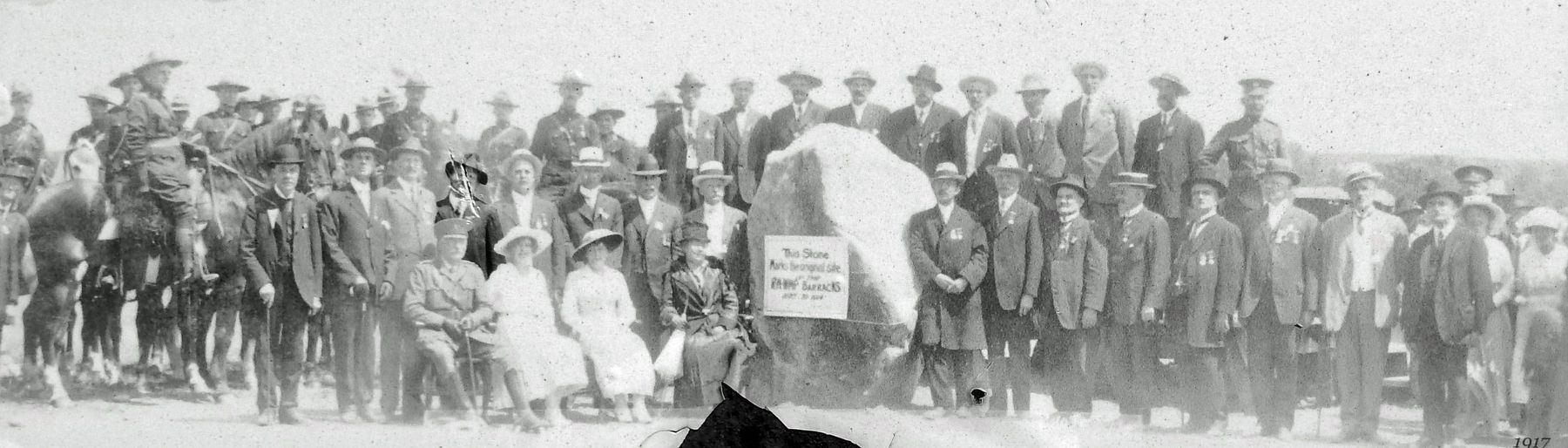
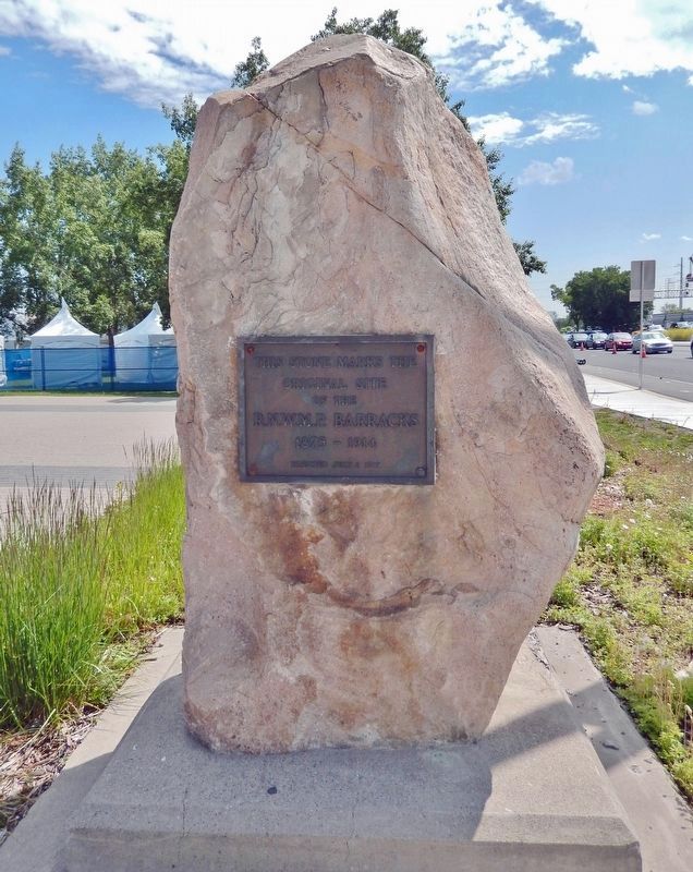
In 1917, on the 42nd anniversary of their arrival, the NWMP Veterans and the Colonel Macleod Chapter of the Imperial Order of the Daughters of the British Empire placed a sandstone boulder and a plaque to commemorate the location of the original Fort Calgary. “The rock” remained the only visible reminder of the city’s origins until the 1970s, when the site was reclaimed for the people of Calgary.
Family History
From 2008 to 2013, the Chairman of the Board of the Fort Calgary Preservation Society was Jack Marshall, grandson of Sgt. JJ Marshall. Jack's passion and commitment to Fort Calgary were instrumental in the preservation and advancement of Fort Calgary during the planning of East Village.
Topics.
this page online
Location. 51° 2.648′ N, 114° 2.881′ W. Marker is in Calgary, Alberta, in Calgary Metropolitan Region. It is in East Village. It is at the intersection of 9 Avenue Southeast and 6 Street Southeast, on the right when traveling west on 9 Avenue Southeast. Marker and rock monument are located near the southwest corner of the Fort Calgary National Historic Site grounds. Touch for map. Marker is at or near this postal address: 750 9 Avenue Southeast, Calgary AB T2G 5E1, Canada. Touch for directions.

Regionally, this marker is in the Calgary Area. It is also in the Prairies. Globally, it is in North America, the Western Hemisphere, the Western World, and the Anglosphere. Historically, it finds itself in what was once a British colony and also Rupert’s Land.
Other nearby markers. At least 8 other markers are within walking distance of this marker: Connections (approx. 0.2 kilometers away); Calgarians Rediscover Fort Calgary (approx. 0.2 kilometers away); Wars, Depression and Oil
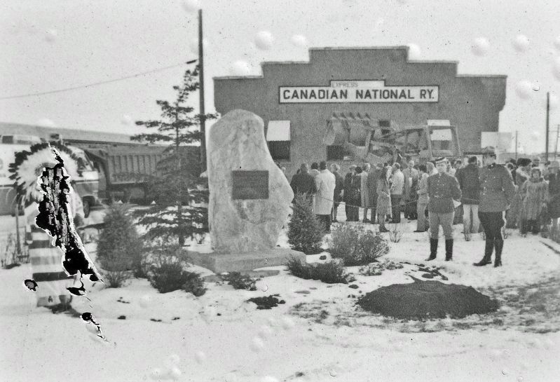
Glenbow Archives M-8377-1-2
2. Marker detail: Fort Calgary, Nov. 27, 1974
The rock at the sod turning for Fort Calgary, November 27, 1974. Chief David Crowchild (Tsuu T’ina) on left.
Related markers. Click here for a list of markers that are related to this marker. Fort Calgary National Historic Site
Also see . . . Calgary History.
In the fall of 1875, the site became a post of the North-West Mounted Police. The NWMP detachment was assigned to protect the western plains from US whisky traders, and to protect the fur trade. The I. G. Baker Company of Fort Benton, Montana, was contracted to construct a suitable fort. At Christmas dinner NWMP Inspector Éphrem-A. Brisebois christened the unnamed Fort "Fort Brisebois", a decision which caught the ire of his superiors Colonel James Macleod and Major Acheson Irvine. Major Irvine cancelled the order by Brisebois and suggested the name "Calgary" put forward by Colonel Macleod. In the spring of(Submitted on April 30, 2023, by Cosmos Mariner of Cape Canaveral, Florida.)1876 Fort Calgary was officially established.Glenbow Archives NC-15-53. Marker detail: Unveiling of the rock, July 2, 1917.NWMP Veteran Sgt. JJ Marshall is standing fourth from the left, second row. The rock was first placed at 8th Avenue and 6th Street SE.
Photographed by Cosmos Mariner, July 1, 2022
4. R.N.W.M.P. Barracks Monument - "The Rock"
Photographed by Cosmos Mariner, July 1, 2022
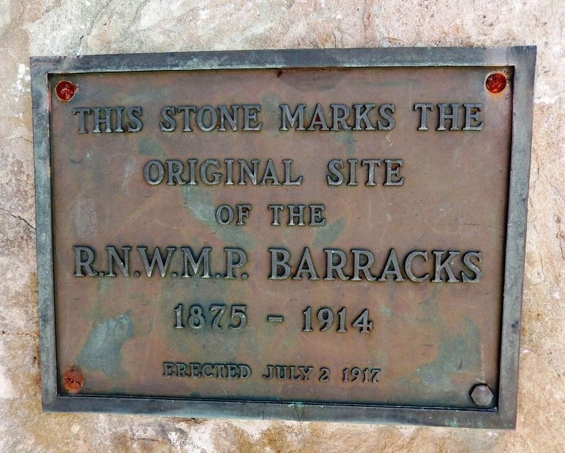
5. R.N.W.M.P. Barracks Monument Plaque
Original Site
of the
R.N.W.M.P. Barracks
1875-1914
Erected July 2 1917

Photographed by Cosmos Mariner, July 1, 2022
6. Keeping Memory Alive: The Rock Marker
Credits. This page was last revised on May 4, 2023. It was originally submitted on April 28, 2023, by Cosmos Mariner of Cape Canaveral, Florida. This page has been viewed 569 times since then and 52 times this year. Photos: 1, 2, 3, 4, 5, 6. submitted on April 30, 2023, by Cosmos Mariner of Cape Canaveral, Florida.
