Bristol in Bristol County, Rhode Island — The American Northeast (New England)
Historical Bristol
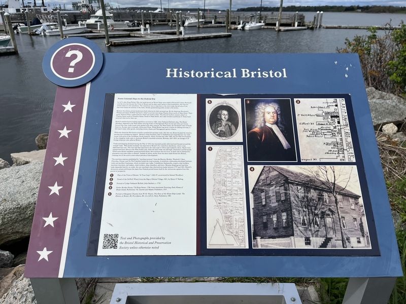
From Colonial Days to the Federal Era
— ❔ —
In 1675, after King Philip's War, the lands known as Mount Hope were ceded to Plymouth Colony. Plymouth sold the area that became the Town of Bristol and its deep water harbor to four proprietors, who laid out streets relative to the waterfront. The waterfront was so important to the town's plan that all nine of the east-west streets ran directly to the water, thereby guaranteeing public access to the harbor.
Between the streets, private landowners built wharves for their personal use. By the American Revolution, William and James DeWolf had built a wharf on private land along Thames Street north of State Street. Their uncle, Simeon Potter, constructed his wharf just north of that. The Church brothers owned a wharf on Thames Street north of Franklin Street. South of State Street, the Usher brothers and Rouse T. Potter built personal wharves for their use.
Bristol's earliest known trading expedition occurred in 1686, when Nathaniel Byfield's ship, The Bristol Merchant, departed to the West Indies carrying stocks of Narragansett Pacer horses and other provisions. Around this time, trade routes were opened with other colonies, the West Indies, the Northeast coast of South America, Europe, and, eventually, Africa and China. While Bristol was never a center for fishing activities, it did export many other goods, including onions, cheese and Narragansett-grown tobacco.
While the American Revolution severely curtailed all maritime trade, after the war, Bristol bucked the trend to develop into a prosperous seaport. Bristol's rising merchant class re-established and expanded pre-war trade routes with ports in the Caribbean, South America, Africa, Europe and, after 1804, the Far East Involvement in the triangular trade came to dominate Bristol's maritime economy. Between 1801-1825, an average of 50 foreign ships per year called at Bristol.
Trade and shipping declined during the War of 1812, but resumed quickly afterward and focused around triangular trade. West Indies molasses was important to Bristol's five waterfront distilleries, where it was fashioned into rum. The rum was then exported to the west coast of Africa and traded for slaves. Slaves were transported from Africa to the West Indies, and, while the slave trade was still legal, Charleston and Savannah. While some Bristol residents owned personal slaves, slave auctions did not occur, as there was no demand for plantation-style slave labor in Bristol. Instead of slaves, money from the slave trade flowed into Bristol, creating one of the town's most robust periods of development.
The maritime empires established by "merchant princes" from the Bourne, Borden, Wardwell, Usher, :Churches, Diman,
Topics. This historical marker is listed in these topic lists: African Americans • Colonial Era • Industry & Commerce • Settlements & Settlers • Waterways & Vessels. A significant historical year for this entry is 1975.
Location. 41° 40.163′ N, 71° 16.712′ W. Marker is in Bristol, Rhode Island, in Bristol County. Marker can be reached from Thames Street north of John Street, on the left when traveling north. Touch for map. Marker is at or near this postal address: 201 Thames St, Bristol RI 02809, United States of America. Touch for directions.
Other nearby markers. At least 8 other markers are within walking distance of this marker. Spc Michael Andrade Memorial Boardwalk (here, next to this marker); a different marker also named Historical Bristol (within shouting distance of this marker); Historical Hurricane Flooding (within shouting distance of this marker); Historic Distillery Site (about 400 feet away, measured in a direct line); James DeWolf (about 400 feet away); Firefighters' Memorial Park (about 500 feet away); World War I Memorial / American Legion Memorial Square (about 600 feet away); The Easterbrooks-Paull Block (about 600 feet away). Touch for a list and map of all markers in Bristol.
Additional keywords. human trafficking
Credits. This page was last revised on May 9, 2023. It was originally submitted on May 9, 2023, by Devry Becker Jones of Washington, District of Columbia. This page has been viewed 52 times since then and 13 times this year. Photos: 1, 2. submitted on May 9, 2023, by Devry Becker Jones of Washington, District of Columbia.

