Bristol in Bristol County, Rhode Island — The American Northeast (New England)
Historical Bristol
Early Trade and Industry
— ❔ —
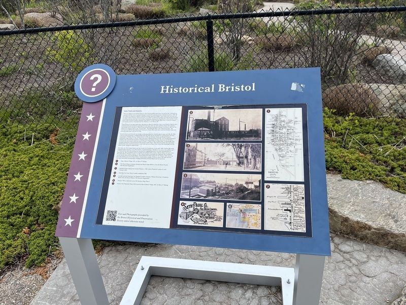
With the collapse of the DeWolf empire in 1825, Bristol's golden years came to an abrupt halt. Although the maritime economy would eventually rebound, it would never reach the plateau it had known prior to 1825. By the 1830s, new pressures on Bristol's waterfront brought significant change. Newer ships with iron hulls were too deep to dock at Bristol's wharves and piers. In an effort to address this problem, the wharves were extended by adding retaining walls filled with boulders. Nonetheless, shipping fell off greatly. For a short period of time, Bristol tried its hand and whaling, amassing a small fleet of 19 small whaling vessels. But, it could not compete with whaling centers in Nantucket and New Bedford, or even Warren, RI.
The invention of the steam engine had a big impact on Bristol's waterfront. One by one, Bristol's wharves were sold, and steam-powered factory buildings were built upon them. In 1836, the Bristol Steam Mill Company was founded on the west side of Thames Street between State and Bradford Streets. It burned in 1843 and was rebuilt as the Namquit Mill, or the "Uptown Mill". The Pokanoket Mill, or the "Downtown Mill", was constructed in 1839 between Church and Constitution Streets. Both mills were owned by the same owners and produced cotton cloth until the Civil War.
Bristol's wharves and factories were diverse, producing products as varied as oakum, sugar, and rifles. By 1840, a factory producing oakum, a substance made from rope fiber and tar and useful for caulking ships, had been constructed on Franklin Street at Thames Street. In 1848, the Dimond, Norris, and Barnes Company established a sugar refinery on Norris' wharf, just north of Bradford Street. By 1851, the Thompson Stanton & Company ship yard had been founded on Thames Street at the bottom of Oliver Street and the Fall River ironworks had constructed a wharf just north of Rouse T. Potter's Wharf at State Street. A wheelwright shop occupied a small part of the waterfront at the bottom of John Street. These factories pushed other businesses eastward from their waterfront locations to side streets and up to Hope Street, where they intermixed with the earlier, strictly residential neighborhood.
Over time, the mills changed hands, and went in and out of production. In the early 1850s, Ambrose Burnside, a Bristol resident and later a Civil War General, proposed building a rifle factory on a site at the southern end of Thames Street. After the building was consumed by a neighborhood fire in the early morning hours of December 25, 1853, he opted to move to a location off of Hope Street, south of Burton Street, now part of Herreschoff Marine Museum complex. In 1904, Charles Rockwell purchased the
Topics. This historical marker is listed in these topic lists: Animals • Industry & Commerce • Roads & Vehicles • Waterways & Vessels. A significant historical year for this entry is 1825.
Location. 41° 40.29′ N, 71° 16.781′ W. Marker is in Bristol, Rhode Island, in Bristol County. Marker can be reached from the intersection of Thames Street and Bradford Street, on the right when traveling south. Touch for map. Marker is at or near this postal address: 345 Thames St, Bristol RI 02809, United States of America. Touch for directions.
Other nearby markers. At least 8 other markers are within walking distance of this marker. A different marker also named Historical Bristol (a few steps from this marker); Historic Distillery Site (about 400 feet away, measured in a direct line); a different marker also named Historical Bristol (about 500 feet away); James DeWolf (about 500 feet away); Columbus Quincentennial Memorial (about 500 feet away); Historical Hurricane Flooding (about 600 feet away); a different marker also named Historical Bristol (about 700 feet away); Memorial Square (about 700 feet away). Touch for a list and map of all markers in Bristol.
Credits. This page was last revised on May 9, 2023. It was originally submitted on May 9, 2023, by Devry Becker Jones of Washington, District of Columbia. This page has been viewed 81 times since then and 42 times this year. Photos: 1, 2. submitted on May 9, 2023, by Devry Becker Jones of Washington, District of Columbia.

