Warren in Bristol County, Rhode Island — The American Northeast (New England)
The Oyster Industry
Warren Historic Site
— N 41° 73' 10", W -71° 28' 66" —
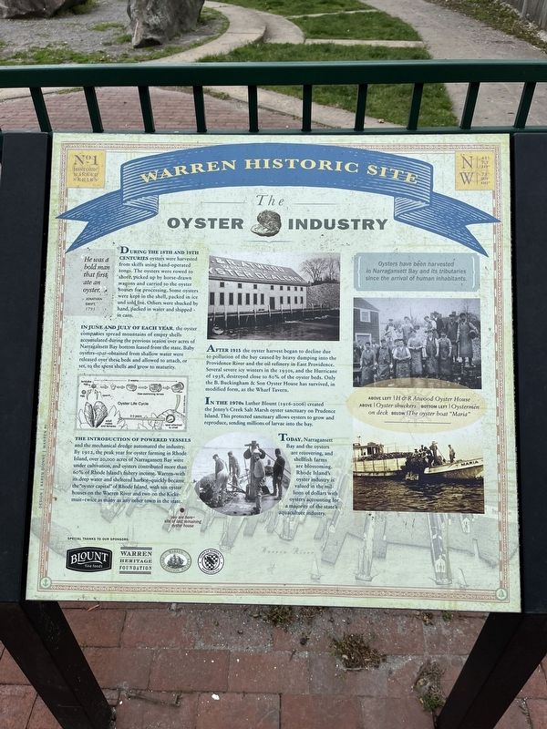
"He was a bold man that first ate an oyster."
- Jonathan Swift, 1793
During the 18th and 19th centuries oysters were harvested from skiffs using hand-operated tongs. The oysters were rowed to shore, picked up by horse-drawn wagons and carried to the oyster houses for processing. Some oysters were kept in the shell, packed in ice and sold live. Others were shucked by hand, packed in water and shipped in cans.
In June and July of each year, the oyster companies spread mountains of empty shells accumulated during the previous season over acres of Narragansett Bay bottom leased from the state. Baby oysters-spat-obtained from shallow water were released over these beds and allowed to attach, or set, to the spent shells and grow to maturity.
The introduction of powered vessels and the mechanical dredge automated the industry. By 1912, the peak year for oyster farming in Rhode Island, over 20,000 acres of Narragansett Bay were under cultivation, and oysters contributed more than 60% of Rhode Island's fishery income. Warren-with its deep water and sheltered harbor-quickly became the "oyster capital" of Rhode Island, with ten oyster houses on the Warren River and two on the Kickemuit-twice as many as any other town in the state.
After 1915 the oyster harvest began to decline due to pollution of the bay caused by heavy dumping into the Providence River and the oil refinery in East Providence. Several severe icy winters in the 1930s, and the Hurricane of 1938, destroyed close to 80% of the oyster beds. Only the B. Buckingham & Son Oyster House has survived, in modified form, as the Wharf Tavern.
In the 1970s Luther Blount (1916-2006) created the Jenny's Creek Salt Marsh oyster sanctuary on Prudence Island. This protected sanctuary allows oysters to grow and reproduce, sending millions of larvae into the bay.
Today, Narragansett Bay and the oysters are recovering, and shellfish farms are blossoming. Rhode Island's oyster industry is valued in the millions of dollars with oysters accounting for a majority of the state's aquaculture industry.
[Caption:]
Oysters have been harvested in Narragansett Bay and its tributaries since the arrival of human inhabitants.
Erected by Blount Fine Foods; Warren Heritage Foundation; Warren Preservation Society; Town of Warren, Rhode Island. (Marker Number 1.)
Topics. This historical marker is listed in these topic lists: Agriculture • Animals • Industry & Commerce • Waterways & Vessels. A significant historical year for this entry is 1793.
Location.
Other nearby markers. At least 8 other markers are within walking distance of this marker. Massasoit Park Sacred Circle Monument (here, next to this marker); The Middle Passage (about 500 feet away, measured in a direct line); The First Methodist Church (about 600 feet away); Veterans Memorial (about 600 feet away); Warren Honor Roll (about 600 feet away); The Baptist Church in Warren (about 700 feet away); Baptist Church in Warren, R.I. (about 700 feet away); The Warren Armory (approx. 0.2 miles away). Touch for a list and map of all markers in Warren.
Credits. This page was last revised on May 10, 2023. It was originally submitted on May 10, 2023, by Devry Becker Jones of Washington, District of Columbia. This page has been viewed 226 times since then and 55 times this year. Photos: 1, 2. submitted on May 10, 2023, by Devry Becker Jones of Washington, District of Columbia.

