Downtown Providence in Providence County, Rhode Island — The American Northeast (New England)
Chinatown on Empire
Westminster Street
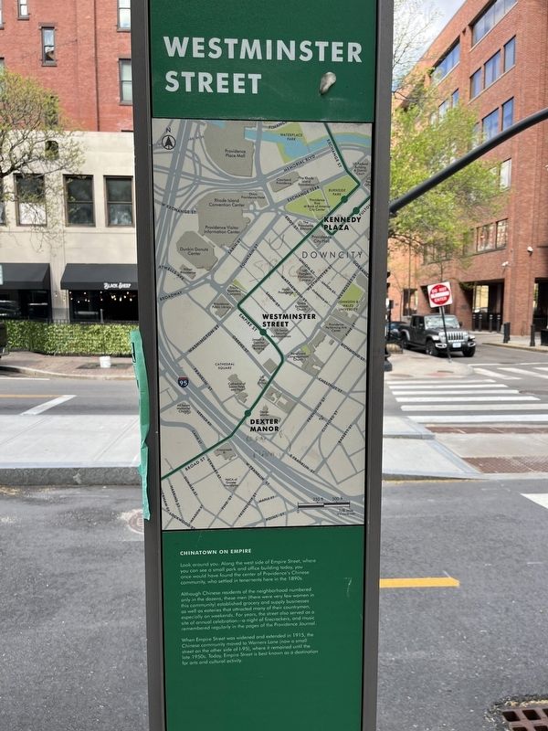
Look around you. Along the west side of Empire Street, where you can see a small park and office building today, you would have found the center of Providence's Chinese community, who settled in tenements here in the 1890s.
Although Chinese residents of the neighborhood numbered only in the dozens, these men (there were very few women in this community), established grocery and supply businesses as well as eateries that attracted many of their countrymen, especially on weekends. For years, the street also served as a site of annual celebration-a night of firecrackers, and music remembered regularly in the pages of the Providence Journal.
When Empire Street was widened and extended in 1915, the Chinese community moved to Warners Lane (now a small street on the other side of I-95), where it remained until the late 1950s. Today, Empire Street is best known as a destination for arts and cultural activity.
Topics. This historical marker is listed in these topic lists: Asian Americans • Immigration • Industry & Commerce • Settlements & Settlers. A significant historical year for this entry is 1915.
Location. 41° 49.264′ N, 71° 24.929′ W.
this page online

Regionally, this marker is on Narragansett Bay. It is also in the American Northeast, in New England, and on the Eastern Seaboard. Globally, it is in the North Atlantic Region, North America, the Western Hemisphere, the Western World, and the Anglosphere. Historically, it finds itself in what was once one of the original Thirteen Colonies.
Other nearby markers. At least 8 other markers are within walking distance of this marker: First Universalist Church (about 500 feet away, measured in a direct line); Styles (about 500 feet away); Beneficent Congregational Church (about 500 feet away); Thomas A. Doyle (about 600 feet away); First Professional Theater (about 600 feet away); Annye (about 600 feet away); Repentance for Slavery (about 700 feet away); Dyer Heirs Building (about
Credits. This page was last revised on June 5, 2024. It was originally submitted on May 10, 2023, by Devry Becker Jones of Washington, District of Columbia. This page has been viewed 378 times since then and 40 times this year. Photos: 1, 2, 3. submitted on May 10, 2023, by Devry Becker Jones of Washington, District of Columbia.
