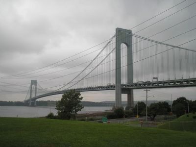
Fort Wadsworth on Staten Island in Richmond County, New York — The American Northeast (Mid-Atlantic)
Verrazano – Narrows Bridge
“We found a pleasant place below steep little hills. And from among those hills a mighty deep-mouthed river ran into the sea.” Giovanni da Verrazano, Italian explorer, 1524
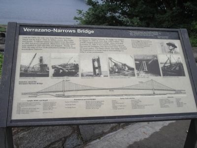
Until the 1960s, the only way from Brooklyn to Staten Island was by water – first by Indian canoes, then boats and ferries. A railroad tunnel was started from Brooklyn in 1923, but never completed. Plans for a vehicular tunnel were studied in 1929 and 1942, but dropped. Finally, in 1946, the state of New York authorized a bridge to be built across the these Narrows.
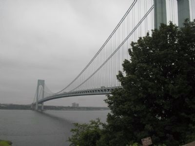
Designed by Othmar Ammann, the bridge was started on August 13, 1959, by more than 1,000 workers. The “world’s longest suspension bridge” when dedicated November 21, 1964, it was named for Italian explorer Giovanni da Verrazano, who discovered these Narrows 440 years earlier. For Staten Island, this bridge marked the beginning of a change from a rural landscape to today’s urban environment.
Erected by National Park Service, U.S. Department of the Interior.
Topics. This historical marker is listed in these topic lists: Bridges & Viaducts • Waterways & Vessels. A significant historical date for this entry is November 21, 1918.
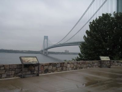
Location. 40° 36.282′ N, 74° 3.308′ W. Marker is on Staten Island, New York, in Richmond County. It is in Fort Wadsworth. Marker is on Hudson Road, on the right when traveling north. Marker is located in the Fort Wadsworth Unit of Gateway National Recreation Area. Touch for map. Marker is in this post office area: Staten Island NY 10305, United States of America. Touch for directions.
Other nearby markers. At least 8 other markers are within walking distance of this marker. Battery Weed (a few steps from this marker); Fort Tompkins (a few steps from this marker); Defending New York Harbor (a few steps from this marker); Fort Wadsworth (within shouting distance of this marker); Battery Duane (within shouting distance of this marker); a different marker also named Battery Weed (about 300 feet away, measured in a direct line); Torpedo Building (about 300 feet away); South Cliff (about 300 feet away). Touch for a list and map of all markers in Staten Island.
More about this marker. Several photographs appear on the marker. One is of bridge designer Othmar Hermann Ammann who also designed nearby Bayonne Bridge, as well as the George Washington, Delaware Memorial, and Bronx-Whitestone Bridges among others. Other photos depict various stages of the bridge’s construction, including Foundations laid in 1959, Tower pedestals built in 1960, Towers erected in 1961, Cables strung to Anchorages in 1962, Decks attached in 1963 and Roadway pavement laid in 1964.
The bottom of the marker contains a
diagram of the Verrazano-Narrows Bridge, indicating the Towers, Pedestals, Anchorage, Decks and Cables. Below this are some statistics about the bridge. These include:
Length, Width, and Height
Length (including approach ramps): . 13,700 feet (4,176 m)
Length from anchorage to anchorage: . 6,690 feet (2,039 m)
Main Span (between towers): . . . . . . . 4,260 feet (1,298 m)
Width: . . . . . . . . . . . . . . . . . . . . . . . . . . . . . 103 feet (31 m)
Height of Towers (above high tide): . 690 feet high (210 m)
Height above water (summer): . . . . . . . . . . 228 feet (70 m)
Height above water (winter, due to bridge contraction): . . . . . . . . . . . . . 240 feet (74 m)
Foundations and Anchorages
Depth of Foundations: . . . . . 105 feet (32 m) in Staten Island; 170 feet (52 m) in Brooklyn
Anchorage Depth: . . . . . . 76 feet (23 m) in Staten Island; 52 feet (16 m) in Brooklyn
Anchorage Bases: . . . . . . . . 230 feet (70 m) wide and 345 feet (105 m) long
Dates, Cost, and Use
Started: . . . . . . . . . . . . . . . . . . August 13, 1959
Dedicated: . . . . . . . . . . . . . . . . November 21, 1964
Lower Deck Opened: . . . . . . . . June 28, 1969
Number of Traffic Lanes: . . . . . 6 on the upper level; 6 on the lower level
Capacity: . . . . . . . . . . . . . . . . . 48 million cars per year
Average Annual Use: . . . . . . . . 33 million cars per year
Materials
Diameter of Cable . . . . . . . . 35½ inches
Length of One Cable: . . . . . . 7,305 feet
Number of Wires per Cable: . . . . 36,108
Total Length of Cable Wire: . . . 143,000 miles
Concrete: . . . . . . . . . . 600,000 cubic yards
Structural Steel: . . . . . . . . . . 120,000 tons
Reinforcing Steel: . . . . . . . . . . 24,000 tons
Credits. This page was last revised on January 18, 2024. It was originally submitted on August 14, 2009, by Bill Coughlin of Woodland Park, New Jersey. This page has been viewed 1,955 times since then and 41 times this year. Last updated on September 9, 2009, by Jay Shuffield of New York, New York. Photos: 1, 2, 3, 4, 5. submitted on August 14, 2009, by Bill Coughlin of Woodland Park, New Jersey. • J. J. Prats was the editor who published this page.
