Downtown Providence in Providence County, Rhode Island — The American Northeast (New England)
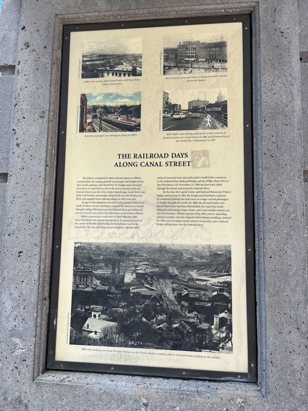
The Railroad Days Along Canal Street
Providence completed its third railroad station in 1898 to accommodate the surging growth in passenger and freight service that would continue until World War II. Freight yards stretched from here at Canal Street as far to the west as the eye could see, beyond what is now the Civic Center Interchange. Canal Street was lined with butcher and produce shops built over the Moshassuck River and supplied from railroad sidings on their west side.
As part of the expansion, elevated tracks crossed Canal Street south of where you are standing to connect the station to a tunnel through College Hill and across the Seekonk River, providing rail service to points east and to East Bay towns as far south as Bristol.
Before construction could start in April 1906, the 1840 stucco finished stone arsenal was moved to its present location at the corner of Benefit and Meeting Streets to make way for the east portal. The one mile long tunnel resulted in 200,000 cubic yards of excavated rock and earth used to build both a causeway to the Seekonk River Railroad Bridge and the Wilkes-Barre Pier in East Providence. On November 15, 1908 the first rain rolled through the tunnel and across the Seekonk River.
By the time the Capital Center and Railroad Relocation Project began construction in 1982, the freight yards had been replaced by commuter parking lots and trains no longer carried passengers or freight through the tunnel. By 1988, the elevated tracks over North Main Street had been demolished, the main line tracks relocated north along Gaspee Street, and a new smaller station was open for business. All that was left of the 19th century sprawling railroad complex were the original Union Station buildings restored for official use, an empty tunnel sealed at its portals, and a railroad bridge rusting away over the Seekonk River.
[Captions:]
1890's view of shop-lined Canal Street with State House under construction.
East Bay passenger cars waiting at siding in 1920's.
Horse-drawn carts and trains in foreground later become Memorial Square.
Mid-1960's view looking south prior to the removal of elevated tracks over Canal Street in 1982 and dismantling of the World War I Monument in 1987.
1909 view looking west from Prospect Terrace at the Union Station complex and its elevated tracks leading to the tunnel.
Topics. This historical marker is listed in these topic lists: Bridges & Viaducts • Industry & Commerce • Railroads & Streetcars • Roads & Vehicles • Waterways & Vessels. A significant historical month for this entry is April 1906.
Location. 41° 49.677′ N, 71° 24.634′
Other nearby markers. At least 8 other markers are within walking distance of this marker. Lady Carrington and The Blackstone Canal (here, next to this marker); Aquene. Eniskeetompowaug. (about 300 feet away, measured in a direct line); Steeple Street (about 300 feet away); The Moshassuck River (about 300 feet away); Steeple Street Complex (about 300 feet away); The Woonasquatucket River (about 400 feet away); a different marker also named Steeple Street (about 400 feet away); The Prophet of Religious Freedom (about 400 feet away). Touch for a list and map of all markers in Providence.
Credits. This page was last revised on May 12, 2023. It was originally submitted on May 12, 2023, by Devry Becker Jones of Washington, District of Columbia. This page has been viewed 47 times since then and 13 times this year. Photos: 1, 2. submitted on May 12, 2023, by Devry Becker Jones of Washington, District of Columbia.

